An official website of the United States government
Here's how you know
Official websites use .gov A
.gov website belongs to an official government
organization in the United States.
Secure .gov websites use HTTPS A
lock (
) or https:// means you've safely connected to
the .gov website. Share sensitive information only on official,
secure websites.
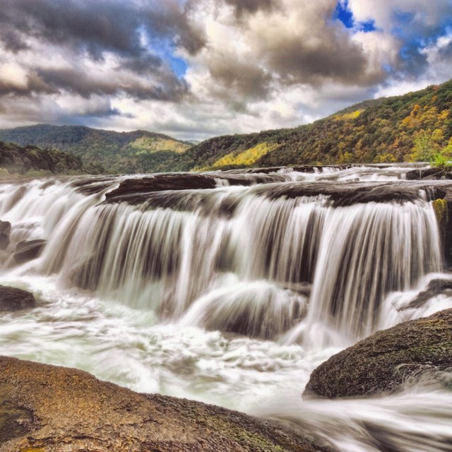
Sandstone Falls is a popular destination at New River Gorge National Park and Preserve.
NPS / Dave Bieri
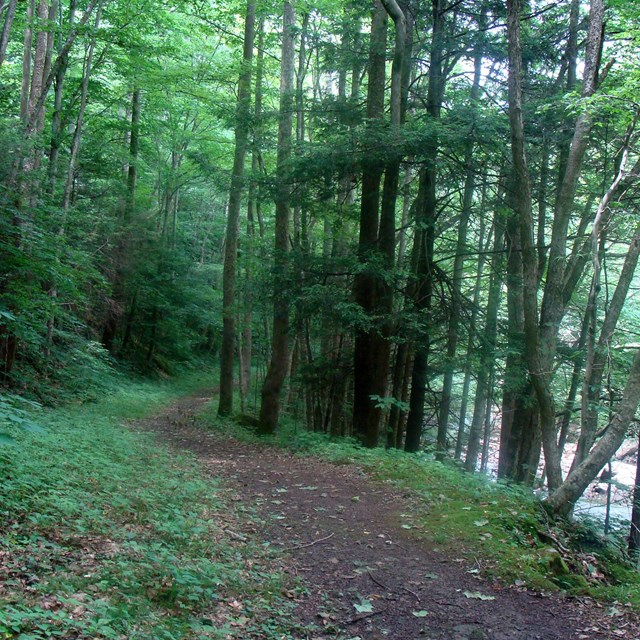
Waterfalls are a common site in national parks. While there are only a few true waterfalls on the New River, there is no lack of waterfalls in the park. Many tributaries in the New River watershed flow into the gorge and cascade over rocks to create waterfalls. Visitors to the park may see some of the larger waterfalls through scenic drives and hiking trails.
New River Gorge Waterfall Tour
The New River Gorge Waterfall Tour follows the path of eight waterfalls starting north of the park near the town of Gauley Bridge and ending at the famous Sandstone Falls. Four of the falls are accessible from the road and four require hiking on trails. Trails may contain uneven terrain, steep slopes, and distances of up to two miles round trip to reach the falls. The total hiking distance to complete this tour is about 4.5 miles. Visitors should consider both driving distances as well as hiking distances when determining which falls to visit in one day. It is possible to complete the tour in one day, but it is not recommended.
Kanawha Falls span the entire width of the Kanawha River. The Kanawha River is formed by the confluence of the New and Gauley Rivers near the town of Gauley Bridge. Approximately one mile downstream from the confluence, a sandstone ledge across the river forms the falls. At its highest point, Kanawha Falls drops fifteen feet. A low dam above the falls diverts water into a hydropower facility. The falls are enjoyable to see at any water level.
Directions
Kanawha Falls is located outside the park.
From Canyon Rim Visitor Center: Take US-19 north 4.8 miles to the US-60 exit. Turn right to follow US-60 west towards Gauley Bridge for 17 miles passing through the town of Ansted and past Hawks Nest State Park. At the town of Gauley Bridge, continue another 0.75 miles to reach a dirt parking area on the left. The falls are visible from the road with no hiking required. Picnic tables are located nearby.
From Charleston, WV: Take US-60, the Midland Trail, east. From I-64, take exit 96 towards Belle. Continue following the Kanawha River through multiple small towns for 31 miles. After passing the falls, a dirt parking lot will be on the right. Picnic tables are located nearby.
Stop 2 - Cathedral Falls near the town of Gauley Bridge
NPS / Dave Bieri
2. Cathedral Falls
Near the town of Gauley Bridge, Cane Creek drops 60 feet over a rocky ledge of shale and sandstone to form one of the highest waterfalls in West Virginia. Cathedral Falls is easily accessed and viewed from the road. A paved path to a bridge offers good views of the falls. A short dirt trail leads to a closer look. The short trail is not accessible and may be slippery. Use caution when walking closer to the base of the falls.
Directions
Cathedral Falls is located outside the park.
From Kanawha Falls: Continue west on Highway 60 through the town of Gauley Bridge towards Ansted. In 2.7 miles there will be a small parking lot on the left marked for Cathedral Falls. Follow the short trail from the parking lot to reach a closer view of the falls.
From Canyon Rim Visitor Center: Take US-19 north. Exit to follow Highway 60 west through Ansted towards the town of Gauley Bridge. In 14.3 miles, there will be a small parking lot on the right marked for Cathedral Falls. Follow the short trail from the parking lot to reach a closer view of the falls.
Stop 3 - Kaymoor Mine Falls on Fayette Station Road at Wolf Creek
NPS / Dave Bieri
3. Kaymoor Mine Falls at Wolf Creek
This beautiful waterfall is actually drainage from Kaymoor Mine that flows into Wolf Creek. The falls are located on the Kaymoor Trail near Fayette Station Road. Since this trail is on the side of the gorge, visitors are encouraged to be careful and keep a good distance from any steep dropoffs on the trail. During the autumn and winter seasons, the falls may be visible from the road. Hiking is required to reach this falls; Wolf Creek Falls is not accessible.
Directions
The falls are located on the Kaymoor Trail near the Wolf Creek Trailhead on Fayette Station Road.
Travel Advisory: Fayette Station Road is a narrow one-way road with sharp curves and low clearance. Vehicles over 12 feet of height cannot drive on Fayette Station Road; this road is not suitable for large vehicles over 25 feet in length or trailers.
From Cathedral Falls: Follow US-60 W past Hawk's Nest State Park and the town of Ansted. Take the ramp to US-19 S and continue for 4.6 miles. Turn left onto Lansing Edmond Road and continue for 0.4 miles. At the brown sign, turn right onto Fayette Station Road then veer left to stay on Fayette Station Road. Continue onto the one way road for 4.3 miles, crossing the Tunney Hunsaker Bridge. Parallel parking is available on the right side of the road after the sharp curve past the trailhead.
From Canyon Rim Visitor Center: Follow US-19 north 0.3 miles to the very first right. Turn right onto Lansing Edmond Road and continue for 0.4 miles. At the brown sign, turn right onto Fayette Station Road then veer left to stay on Fayette Station Road. Continue onto the one way road for 4.3 miles, crossing the Tunney Hunsaker Bridge. Parallel parking is available on the right side of the road after the sharp curve past the trailhead.
To Hike to the Falls: On the Kaymoor Trail, hike 0.1 miles across the bridge and up the hill. The falls are located on the right side of the trail.
Stop 4 - Butcher Branch Falls near the Kaymoor Top Trailhead
Butcher Branch Falls is created from a small creek flowing down tiered sandstone in multiple cascades. This falls is rainfall dependent and may not be flowing in drier weather. Hiking is required to reach this falls; Butcher Branch Falls is not accessible.
Directions:
Butcher Branch Falls is located on the Butcher Branch Trail which starts from the Kaymoor Top Trailhead.
From Wolf Creek Falls: Return to Fayette Station Road and continue on the one-way road until it intersects with US-19. Turn right onto US-19 then turn left onto WV-16 at the traffic signal. Continue 0.7 miles through the town of Fayetteville. Turn left onto Gatewood Rd. Follow Gatewood Rd 1.9 miles and take a left onto Kaymoor Rd following signs for Kaymoor Top. Continue for 0.6 miles until the road comes to a T. Take a left to reach the trailhead parking lot.
From Canyon Rim Visitor Center: From the parking lot, head back to US-19 and take a left to head south. Continue across the bridge and take a left onto WV-16. Continue 0.7 miles through the town of Fayetteville. Turn left onto Gatewood Rd. Follow Gatewood Rd 1.9 miles and take a left onto Kaymoor Rd following signs for Kaymoor Top. Continue for 0.6 miles until the road comes to a T and take a left to reach the trailhead parking lot.
To Hike to the Falls: The path to the falls has steep, rocky switchbacks that may be slick when wet. Good shoes are recommended and hiking poles may be useful. From the trailhead, hike 0.3 miles on the Butcher Branch Trail. At the Climbing Access sign, follow the access trail along the sandstone cliff for 0.15 miles.
Stop 5 - Dunloup Falls near the historic town of Thurmond
Dunloup Creek, a tributary of the New River, winds through the park following active railroad tracks until it reaches the New River at the historic town of Thurmond. Along the way, the creek drops 20 feet off a shelf of sandstone to form Dunloup Falls. Lucky visitors may be able to spot a coal train riding the rails just above the falls.
Directions:
Dunloup Falls is located along the road to the historic railroad town of Thurmond.
Travel Advisory: Thurmond Road is winding and narrow at times. Large vehicles over 25 feet in length and trailers are not recommended.
From Butcher Branch Falls: Return back to US-19 through the town of Fayetteville. Take a left to follow US-19 south 10.8 miles past the town of Oak Hill. Turn left at the signal following sings for Glen Jean and the Thurmond Historic District. Immediately take another left and head north on WV-61 for 0.4 miles. Take a right towards Thurmond and follow Thurmond Road for 4.3 miles. The falls are located at an unmarked pullout with a large rock.
From Thurmond Depot: Return to the Thurmond Road by crossing the New River on the one lane bridge. Continue for 2.2 miles past the Rend Trailhead. The falls are located at an unmarked pullout with a large rock.
Stop 6 - Glade Creek Falls near Glade Creek Campground
Louise McLaughlin
6. Glade Creek Falls
Glade Creek has several small falls, cascades, and pools that are local swimming holes. The largest of these falls flows down tiered sandstone steps spanning the width of the creek. Hiking is required to reach this falls; Glade Creek Falls is not accessible.
Directions
Glade Creek Falls is located on the Glade Creek Trail which is accessed from two trailheads. It is strongly recommended to use the campground trailhead.
Travel Advisory: The road to the upper Glade Creek Trailhead is steep, narrow, winding, and unpaved dirt. It is not suitable for most vehicles except those with high clearance and 4WD. The hike from this trailhead to the falls is 9.4 miles roundtrip.
From Dunloup Falls: Return to WV-61 by following the Thurmond Road through Glen Jean. Take a left at the intersection with WV-61. Continue on WV-16 S / WV-61 S for 3.1 miles. Turn left onto WV-61 S near Mount Hope. Follow for 4.4 miles, then turn left onto WV-41 N. In 3.9 miles, there will be a bridge crossing the New River near Prince. Before this bridge, take a slight right onto Glade Creek Rd crossing over the railroad tracks. Follow Glade Creek Rd to the end, about 5.6 miles. The trailhead will be on your right.
From Sandstone Visitor Center: Take a left out of the visitor center parking lot. Turn left onto the onramp for I-64 W towards Beckley. Follow I-64 W for 14.4 miles to exit 124. Continue onto E Beckley Bypass / Joe L Smith Dr for 3.3 miles then turn right onto WV-41 N / Stanaford Rd. After 4.5 miles, turn right to continue on WV-41 N. In 3.9 miles, there will be a bridge crossing the New River near Prince. Before this bridge, take a slight right onto Glade Creek Rd crossing over the railroad tracks. Follow Glade Creek Rd to the end, about 5.6 miles. The trailhead will be on your right.
To Hike to the Falls: From the trailhead parking lot, hike along Glade Creek for 1 mile. The trail has slight elevation gain with brief steeper portions. Some areas may be muddy. Good hiking shoes are recommended.
Stop 7 - Big Branch Falls near Brooks Falls Parking Lot
NPS / Dave Bieri
7 - Big Branch Falls
Big Branch Creek is a feeder creek for the New River near the town of Hinton. It has many small cascades and falls which are visible along the Big Branch Trail. The largest of these plunges nearly 30 feet down tiered sandstone and is located just a short hike from the Big Branch Trailhead. Hiking is required to reach this falls; Big Branch Falls is not accessible.
Directions
Big Branch Falls is located on the Big Branch Trail across from the Brooks Fall parking lot.
From Glade Creek Campground Trailhead: Return to WV-41 by following Glade Creek Rd for 5.6 miles. Cross the railroad tracks and take a slight left onto WV-41 S. Continue for 3.9 miles then turn left to continue on WV-41 S for 4.5 miles. Turn left onto E Beckley Bypass and follow 3.3 miles to I-64 E. Follow signs for I-64 E and merge onto the interstate. Follow for 13.8 miles to exit 139 for Sandstone.
Take a left onto WV-20 S and follow for 10.3 miles to the town of Hinton. Continue through the town of Hinton. At the traffic signal in town, turn right onto WV-20 S / Temple Street. Cross the bridge and take a right onto WV-26 / New River Road. The trailhead will be on the left in 3.9 miles across from the Brooks Falls parking lot.
From Sandstone Visitor Center: Take a left out of the visitor center parking lot. Follow WV-20 S for 10.3 miles to the town of Hinton. Continue through the town of Hinton. At the traffic signal in town, turn right onto WV-20 S / Temple Street. Cross the bridge and take a right onto WV-26 / New River Road. The trailhead will be on the left in 3.9 miles across from the Brooks Falls parking lot.
To Hike to the Falls: From the trailhead, hike clockwise 0.7 miles to reach the falls. Beyond the falls, the trail will become more strenuous for the remainder of the loop. Good hiking shoes are recommended. Visitors may wish to return the way they came to avoid the steeper portions of the trail.
The most iconic waterfall in the park is Sandstone Falls. Spanning 1,500 feet across, it is the largest waterfall on the New River. Several small islands divide the falls into different parts that drop 10 to 25 feet. Although the falls require some walking to view it, the boardwalk is short and accessible.
Safety Advisory: The waters around Sandstone Falls are very swift and dangerous. Remain on the boardwalk or trails when visiting the falls. Anyone near or in the water should always wear a life jacket.
Directions
Sandstone Falls is not located at the Sandstone Visitor Center. It is an approximately 45 minute drive from the visitor center to the falls.
Travel Advisory: The final portion of New River Road to Sandstone Falls is narrow with no yellow line and limited passing space. Large vehicles over 25 feet in length such as RVs are not recommended.
From Big Branch Falls: Take a left onto New River Road and continue north. The parking lot will be on the right in 4.2 miles.
From Sandstone Visitor Center: Take a left out of the visitor center parking lot. Follow WV-20 S for 10.3 miles to the town of Hinton. Continue through the town of Hinton. At the traffic signal in town, turn right onto WV-20 S / Temple Street. Cross the bridge and take a right onto WV-26 / New River Road. The parking lot will be on the right in 8.3 miles.