
NPS Photo
Recent research at Mount Rainier National Park has measured the rate at which the park's glacial riverbeds fill with rock, a process called "aggradation." In most places, the rate is around 3 feet per decade (based on 1997- 2010 data)- not much, until you multiply this number by the more than 120 years that people have maintained permanent residences in places like Longmire. In addition, local topography and variations among Mount Rainier's glaciers mean that in some places the rivers aggrade more quickly.
In a wilderness environment, none of this would matter much. As the riverbed aggrades, the river would simply choose another course, perhaps on the other side of the valley. Today, however, there are roads and campgrounds and buildings on the other side of the valley- structures which do not change in elevation, even as the riverbed rises. To protect the park's facilities, dikes and levees have been built over the years to keep the rivers in convenient channels. Over time, the levees have to be built higher and higher to keep them there. Today, locations throughout the park are in danger of being flooded by glacial rivers. Tahoma Creek, along the Westside Road, and the Carbon River have changed course aggressively over the years. The White River now runs 14 feet above adjacent Highway 410 for two miles. Parts of Longmire are 29 feet below the current elevation of the Nisqually River. The Nisqually River is now nearly level with the park road in several places, including, infamously, the former Sunshine Point Campground. 
NPS Photo GlaciersThe reason Mount Rainier's rivers aggrade instead of erode (like the Colorado River erodes the Grand Canyon) is because of Mount Rainier's glaciers, which supply more rocks than the river can carry away. Mount Rainier is encircled by 25 named glaciers with a combined surface area of more than 30 square miles, the largest glacial system on a single mountain in the United States outside of Alaska. The glaciers form as snow accumulates high on the mountain, where temperatures are too cold even in the summer for all of the snow to melt before winter sets in again. Over the years, the accumulated snow packs down under its own weight, becoming denser and denser, until it becomes ice. In many places, the slopes of this great volcano are steep enough that these massive ice fields begin to flow downhill under the force of gravity. They slide across the ground at their base, tearing and grinding rocks out of the mountain as they move, and they twist and deform under their own weight. Avalanches and erosion deposit more rocks on the surface of the glacier, and eventually, the glacier becomes a thick, frozen mixture of ice and rock.
As the glacier flows down the mountainside at- well- a glacier's pace, about 7 inches per day on average, it eventually reaches an elevation where temperatures are warm enough for it to melt. At this point, the glacier becomes a river, and a source of drinking water, irrigation, and hydroelectric power for natural and human communities downstream. Meanwhile, snow continues to fall near the top of the mountain, replenishing the glacier. When the glacier melts, of course, all of the rock embedded in it melts out of the ice and into the riverbed. The river gradually tumbles the rock downstream, carrying it toward the ocean. The river is constantly rearranging the rock in its bed: piling it up here, washing it away there, then piling it up in a new location and changing course around it, always seeking the easiest path through the debris. This is why glacial riverbeds are wide and rocky, with the river itself braided into constantly-changing channels and sub-channels somewhere down the middle. This on-going process of rocks left behind by glaciers accumulating in rivers is known as aggradation. 
NPS Photo Climate ChangeThe process of aggradation seems to be accelerating. One likely reason is that Mount Rainier's glaciers are melting faster than they are reforming- a sympton of the trend toward warmer temperatures locally over the past century. Glaciers like the Nisqually, which loomed over the park road less than a hundred years ago, have now melted almost out of sight around a bend in the canyon. As the glaciers melt, they release into the the riverbed the huge volumes of rock formerly locked in the ice. Massive piles of rock called moraines, normally trapped between the glacier and the walls of the canyon, also begin to erode into the river. The volume of rock available for the rivers to carry increases and a major flood can cause several decades worth of normal aggradation to occur overnight. The riverbed where the Tacoma Creek flows under the Nisqually Road rose more than four feet during the November 2006 flood, leaving the bottom of the road bridge just five feet above the river. Many scientists believe that the melting of Mount Rainier's glaciers fits a pattern of melting glaciers and other weather phenomena worldwide- a pattern known as "climate change". Most scientists now believe that pollutants released into the air by humans, especially carbon dioxide, have significantly contributed to climate change. 
NPS Photo Looking AheadWhatever the cause, the implications are clear: as Mount Rainier's rivers continue to aggrade, it will become harder and harder to keep them from flooding adjacent roads and facilities. The park will rely more and more on larger and stronger dikes, levees, engineered log jams, and other flood control structures to separate the rivers from the roads. In the long term, park managers will have to consider how much effort is warranted to protect vulnerable facilities. Some roads may be closed permanently, or only repaired well enough to be passable until the next flood. Some structures may be relocated to places less prone to flooding, or perhaps removed from the park entirely. These management questions have become critical at places like the former Sunshine Point Campground, Westside Road, and the Carbon River Road. Planning efforts will carefully consider the likelihood that these places will flood again, maybe in the near future. This may pose significant changes in how we access and develop certain areas of the park, and may require the repurposing of roads and other facilities into infrastructure more appropriate for the floodplains on which they're built. In the long term, park managers will have to find ways of living alongside the powerful forces of nature that continue to reshape this landscape. Transcript
What is a flood? A flood is just too much water in the wrong place. The bigger question is why? Why does too much water end up in the wrong place? The factors that determine whether or not a place will flood are the same no matter where you are. Knowing the components of a flood can also help predict how often and how big or damaging those floods will be when they do occur.
The Carbon River area in the northwest corner of Mount Rainier National Park is notoriously prone to flooding. A flood occurs when there is too much water flowing in a particular place. So what is it about the Carbon River that causes it to flood so frequently? Different places can handle different amounts of water and the Carbon River area deals with a lot. On average, the area gets over 80 inches of precipitation a year. When moisture-laden air from the Pacific ocean collides with the massive slopes of Mount Rainier the result is lots of rain, or at higher elevations, snow. As a result of the frequent rain, the Carbon River area is home to a dense temperate rain forest. Old growth trees, mosses, ferns, and numerous other plants thrive on the high amounts of rainfall. Some of the moisture falls as snow and becomes trapped as part of the Carbon Glacier. Excess water collects in numerous creeks and streams in the area all eventually flowing into the powerful Carbon River. Even under normal conditions, the Carbon River can handle a lot of water. However, even places with a large capacity for water like the Carbon River area have a limit. During the November 2006 flood, the largest flood in the park's recorded history, it rained 18 inches in three days. The Carbon River area normally handles only 17 inches of rain in the entire month of November. Many factors affect whether or not a place like Carbon River can adapt to extreme amounts of rainfall like what fell during November of 2006. The Carbon River is a large river capable of transporting a lot of water. Lush forests divert some rainfall, while glaciers store even more water as ice. However frequent rain can also saturate soils and water log even the densest forest. Changing climate is affecting weather patterns, creating larger storms with more intense rainfall than in the past. A process called aggradation is also restricting the ability of the Carbon River to carry water. Aggradation is the opposite of erosion. Mount Rainier's glaciers create so much rocky material and sediment as they grind down the mountain that the rivers can't move it all. Plus, as climate change melts glaciers faster than ever, even more rocky material enters the river. When the river channels fill up, the river is forced in new directions creating braiding of the river channels. Even under normal circumstances aggradation can cause rivers to dramatically alter course. During flood events, the process of aggradation is accelerated, amplifying the effects of too much water in the system. Often rivers end up flowing through surrounding forests as well as any human construction in the way. Floods are a natural and often necessary part of a healthy environment. Sediments deposited by flood waters provide much needed nutrients for new vegetation. The powerful force of the water scours river beds of debris and creates new habitat for fish and aquatic insects. Floods are also very damaging, particularly to human roads and structures. Unfortunately the Carbon River Road was built along the edge of the Carbon River. When aggradation fills up the river channels the easiest path for the water is often the road itself. This conflict with human use has played out repeatedly throughout the roads history. As long as the conditions that cause flooding persist, then floods will continue to happen in the Carbon River area. Glaciers are shrinking due to climate change, releasing more water and rocky material into the river system. The process of aggradation is accelerating. Rain will continue to fall. Human use however is within our control. By better understanding the anatomy of floods, Mount Rainier National Park plans for the future so that a balance can be struck that allows for the natural processes of the river as well as for human use.
Visit our keyboard shortcuts docs for details
What is a flood? Why do floods occur at Mount Rainier National Park, and how are floods changing the landscape? The video "Anatomy of a Flood" breaks down the answers to these questions using the Carbon River as a prime example. 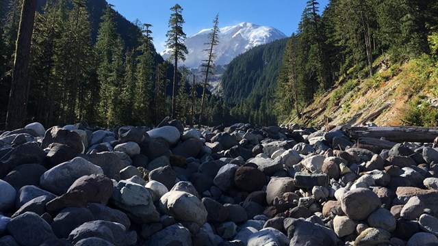
Geohazards
Mount Rainier is an active volcano. Learn more about debris flows and other geologic hazards of this unusual environment. 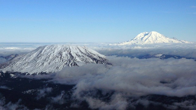
Volcanoes
Mount Rainier is a active volcano. Lava flows and eruptions have shaped the landscape in the past, and evidence can still be seen today. 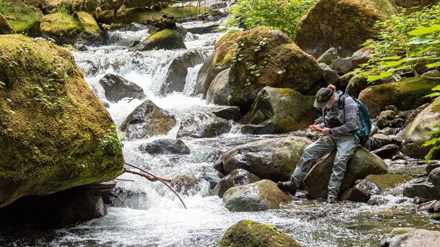
Climate Change Science: Water
Park scientists are studying the effects of climate change, including river temperatures, fish, amphibians, and other water-related areas. |
Last updated: March 24, 2025