Overview
Established in 1972, Fort Bowie National Historic Site protects and interprets the remains of a key territorial military fort and the Butterfield trans-regional stage route, and commemorates the bitter conflict between the Chiricahua Apache and the U.S. military. As with many other cultural sites, the location of these important historic resources is directly related to scarce and important natural resources: a strategically important pass through the rugged mountains of the Arizona–Sonora borderlands, and reliable perennial springs. Issues of natural resource concern at the park include conversion of grasslands to shrublands, the introduction and spread of invasive exotic plants, changing regional land use, and smuggling and illegal migration.
The Sonoran Desert Network monitors air quality, climate, groundwater, invasive exotic plants, landbirds, springs, seeps, and tinajas, and vegetation and soils at Fort Bowie National Historic Site. The results of this work can be found in a variety of publications and other information. The network also maintains species lists for the park.
Park Setting and Key Resources
Size: 404 hectares
Elevation range: 1,417–1,600 meters
Biogeography and physiography
Fort Bowie National Historic Site lies in the Apache Highlands ecoregion. The Apache Highlands comprise the western section of the Chihuahuan Desert and northern limits of the Madrean ecoregions. They are characterized by mountain "sky islands" separated by grassland and desert scrub "seas."
Its location at a biogeographic transition point between the Sonoran and Chihuahuan deserts on the east and west, and the Rocky Mountains and Sierra Madre to the north and south, is reflected in the diverse flora and fauna monitored by the network. The park is part of the Madrean evergreen woodland biome. Average annual precipitation is 9.69 inches (246 mm).
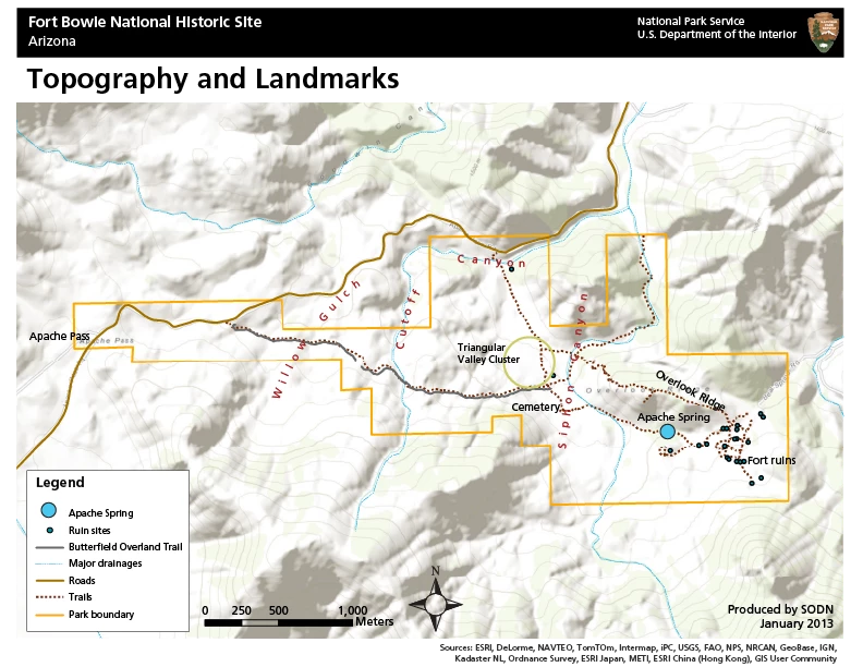
Fort Bowie National Historic Site is located in Apache Pass, which divides the Chiricahua and Dos Cabezas Mountains. These rugged mountain ranges are typical of the basin and range topography of the intermountain west, with the north–south-aligned ranges separating the San Simon and Sulphur Springs valleys. The park contains three steep-gradient, ephemeral riparian systems: Siphon Canyon, Cutoff Canyon, and Willow Gulch.

Local geology and soils
Fort Bowie National Historic Site is centered on the Apache Pass fault, an overthrust block of Permian and Cretaceous limestone atop Precambrian granite. As a result, there is great geologic variation within this relatively small park, with exposed granite outcroppings in the western area and highly stratified and folded calcareous layers in the eastern portions of the unit. A geologic inventory of the park provides more detail. This variance in parent material contributes to eight major soil types, a surprising number for such a small area.
Vegetation
Fort Bowie National Historic Site has high plant diversity for its size, with almost 600 documented species, subspecies, and varieties. The park's vegetation is largely savanna and desert grassland and shrubland types, with dense woodland and forest strips confined to the narrow ephemeral drainages. Wooded shrublands and chaparral vegetation are common on northerly facing, rocky slopes. Many communities consist of chaparral and woodland species, such as juniper, mountain mahogany, scrub oak, pine, and succulents. Low elevations in the park and surrounding areas support more typical desert species, such as creosotebush (Larrea tridentata). Historic grazing and fire suppression have impacted the vegetation of the site, with non-native grass invasion and mesquite expansion into grama (Bouteloua spp.) grasslands. A vegetation mapping report provides more detail.
Climate and hydrology
The climate at Fort Bowie National Historic Site is typical of the Apache Highlands ecoregion: highly variable, bimodal precipitation with a considerable range in daily and seasonal air temperature, and relatively high potential evapotranspiration rates. Approximately half of the annual precipitation falls during summer thunderstorms, where maximum air temperatures can exceed 104°F and lead to violent (and often localized) rainstorms. The bulk of the remaining annual precipitation falls in relatively gentle events of broad extent, occasionally as snow.
Weather and climate data for Fort Bowie National Historic Site and all other Sonoran Desert Network parks can be found at The Climate Analyzer, an interactive website that allows users to create custom graphs and tables from historical and current weather-station data. A weather and climate inventory was created for the Sonoran Desert Network in 2007. A more recent brief shows the magnitude and direction of ongoing changes in climate at Fort Bowie National Historic Site.
Apache Spring and the two Mine Tunnel Springs are groundwater emanating to the surface due to the Apache Pass fault. Other surface-hydrology characteristics are largely the product of local climate patterns and the configuration of the on-site and surrounding watersheds. The rolling terrain, dissected by steep drainages, tends to funnel runoff through Siphon and Cutoff canyons and Willow Gulch, with relatively little on-site water storage within the soil. Locally intense storms can therefore result in tremendous runoff and even mass soil movement events.

Apache Spring
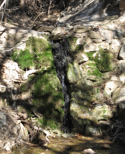
Apache Spring was a key water source for the Apache people (and pre-Apache civilization), and the reason why this location was chosen for Fort Bowie. Its rare and steady supply of fresh water and location near a common travel route made it a highly desirable and disputed site. The spring, which arises from the Apache Pass fault, has been partially diverted to provide water to a neighboring cattle ranch. The remaining flow trickles through the riparian area along the bottom of Siphon Canyon, and disappears into the sandy substrate. No photographs are known to exist that would show us what the spring area looked like in a more natural state, but diversion, water development, and cattle grazing have had an obvious impact on the spring. Nonetheless, the spring remains a central feature of the natural landscape at Fort Bowie.
Human habitation
Prehistoric human use of the area of Fort Bowie National Historic Site appears to have begun around 200 B.C., based on preliminary evidence of the remains of a village that appears to be associated with the Mogollon culture. Protohistoric use is evident in the region, but it was the Chiricahua Apache who dominated this site during the 17–19th centuries AD. The Apache Pass area was the focus of cultural and spiritual activities, with such famous Apache leaders as Cochise, Naiche, and Geronimo spending significant periods in the area with their family-based bands. Apache Pass was also the scene of the infamous "Bascom Affair" that ignited the 11-year conflict between the Chiricahua Apache (led by Cochise) and the U.S. Army, leading to the Battle of Apache Pass and the establishment of Fort Bowie.
The military garrison rapidly outgrew the initial fort, established near Apache Spring in 1862. In 1869, the much-larger second fort was constructed on the plateau above the first fort. The forts served as the foundation for military operations in the region, the headquarters of the Chiricahua Indian Agency during part of the short-lived Chiricahua Reservation (1872–1876), and as a key hub of regional communications and transportation. At the height of operations in 1886, the fort supported more than 300 soldiers and civilians. With the forced removal of the Chiricahua Apache to reservations in Florida and the extension of the Southern Pacific Railroad across the northern reach of the Dos Cabezas Mountains, the need for the fort diminished, and the site was decommissioned in 1894.

Key Issues
Cultural landscape considerations
Natural resources (a strategic pass, perennial water, and productive semi-desert grassland) played a central role in the historical activities that the park commemorates and protects. Managing park vegetation as a cultural landscape is a primary management objective.
Mesquite encroachment and shrubland conversion
Woody plant encroachment into temperate and tropical desert grassland and savanna community types has been widely reported. Invasive shrubs and trees are typically native species that have increased in abundance due to shifting environmental conditions, such as grazing, altered fire regimes, or shifting climate regimes.
In the American Southwest, mesquite plays a pivotal role in shrub encroachment into grasslands and savannas, often converting these systems into dense shrublands and thorn woodlands. As a result, mesquite control has become a major management focus in the region for economic and ecological reasons.
Invasive exotic plants
Biological invasions have increased at unprecedented rates in the past few hundred years. In the American Southwest, historic and current land-management practices, such as livestock grazing and fire suppression, are thought to have made arid lands more susceptible to invasion and subsequent loss of native species and decreased biodiversity. In general, southwestern semi-desert grasslands, savannas, and riparian community types are at greatest risk of invasion due to modified disturbance regimes involving herbivory and fire.
During an exotic plant survey from 1999 to 2001, 26 non-native, introduced plant species were recorded at Fort Bowie, 12 of which were grasses. Most of the other species were annual forbs, along with notable perennials horehound (Marrubium vulgare), tamarisk (Tamarix spp.), Boer's lovegrass (Eragrostis curvula), Lehmann lovegrass (Eragrostis lehmanniana), and Bermuda grass (Cynodon dactylon). In 2002–2003, a vascular-plant inventory added one more species to the non-native list: wand mullein (Verbascum virgatum). Several of these non-natives were introduced to the park as a direct result of human activities, such as past settlement, grazing, farming, excavation, and construction activities.
Changing regional land use and illegal migration
While ranching continues to be an important driver of human activity in southeastern Arizona, there has been a recent increase in demand for exurban housing and services for retirees and telecommuters attracted to the region's scenic landscapes and mild. This trend is expected to continue.
In recent years, national parks near the U.S./Mexico border have experienced dramatic increases in illegal immigrant traffic and associated law-enforcement activities. Within Fort Bowie National Historic Site, most of this traffic is on foot. Impacts include the accumulation of trash, such as backpacks, water bottles, and clothing. In the region, impacts tend to be more severe, with the establishment of well-used trails and campsites, as well as off-road vehicle travel.
Quick Reads
Source: NPS DataStore Saved Search 4929. To search for additional information, visit the NPS DataStore.
Source: NPS DataStore Saved Search 4930. To search for additional information, visit the NPS DataStore.
Last updated: November 1, 2022
