

Theodore Roosevelt Island
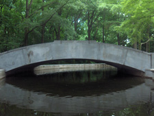
Theodore Roosevelt Island is located in the Potomac River within the geographic boundaries of the District of Columbia. The channel between the island and the Virginia shore is commonly referred to as the Little River, and the smaller island located immediately southwest of Roosevelt Island is known as Little Island. Together the two islands comprise an 88.5-acre naturalistic landscape unique among its heavily urbanized environs. While the island serves as a monument to the 26th President, it maintains a significant history, part of which bears witness to the struggles and successes of African Americans.
African Americans in Service to Their Country
Upon the decree of President Abraham Lincoln's emancipation of all slaves residing in Washington, D.C. on 16 April 1862, the number of fugitive slaves, commonly called contrabands, escaping to the District increased dramatically. Lincoln followed with the Emancipation Proclamation in January 1863, which, in addition to freeing slaves held in Confederate territory, also made possible Black enlistment in the Union Army. Thousands more slaves escaped and moved north. As the war progressed, the area comprising Washington, D.C., and Alexandria, Virginia, became the principal supply center for the entire eastern theater, and the military, government contractors, and private businesses all utilized this influx of freedmen to meet the demands of the war effort.
During the spring of 1863, two white Army chaplains, J.D. Turner and W.G. Raymond, began lobbying the President to raise a regiment from the District's swelling African American population. Lincoln approved their request and in the first week of May 1863 the two men began recruiting for the 1st District of Columbia Colored Volunteers. Scores of contrabands enlisted, and the chaplains also recruited soldiers from hospitals, prisons, and temporary refugee camps. These new recruits made their first public appearance less than two weeks later, marching through the streets of Washington on the afternoon of 15 May. Theodore Roosevelt Island (then known as Mason's Island) became the location for the 1st District of Columbia Colored Volunteers' training grounds and residence.
Although Washington was the seat of the Federal government, it was also a southern city with many residents sympathetic to the Confederate cause, and overtly hostile to the massive influx of African Americans. In this climate, racially motivated violence was not uncommon. In an effort to avoid such an altercation, the first two companies of volunteers were quickly relocated to Mason's Island (Roosevelt Island) on 19 May.
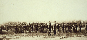
This removal was so secret that white recruiting officers were barred from visiting the island under penalty of arrest, and President Lincoln himself did not know where the colored soldiers were encamped. Despite this secrecy, a gang discovered their location and attacked in early June, severely wounding several soldiers before a detachment of Massachusetts troops arrived to protect them. The violence was probably spurred at least in part by War Department General Order No. 143, which, through the establishment of the Bureau of Colored Troops on 22 May 1863, allowed African Americans to serve in the Union Army as regular soldiers rather than volunteers. By 30 June, ten companies had been formed, all stationed on the island. On this day, the 1st District of Columbia Colored Troops was officially re-designated the 1st United States Colored Troops, the first African American regiment formally mustered into Federal service.
Theodore Roosevelt Island is managed by the National Park Service as part of the George Washington Memorial Parkway for the enjoyment of the American people. The Historic American Landscapes Survey (HALS) documented the island in 2007 with photographs, measured drawings and a written narrative.

