Kīpahulu Moku

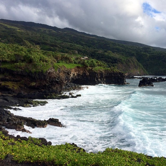
Kīpahulu was once composed of thriving settlements along the coast, and the place of great battles between the chiefs of Maui and the chiefs of Hawaiʻi island, who often controlled East Maui. Kīpahulu has had many layers of occupation since it was first settled by Polynesian voyagers. Throughout all of the changes, Kīpahulu has remained an important moku in East Maui. From mauka to makai Kīpahulu is fertile with good land for growing kalo as well as plentiful other fruits and vegatables, fresh water streams, and plentiful marine resources.
 
Five layers of human settlement in Kipahulu
Timeline showing eras of human occupation and land use in what is now the Kīpahulu District of Haleakalā National Park.

NPS Graphic

 
archeologist
Archeologist records a site in the Kīpahulu District.

NPS Photo

Archeological Sites in Kīpahulu:
Coastal surveys indicate at least 300 archeological features in Kīpahulu. Radiocarbon dating indicates that Kīpahulu was settled sometime between A.D. 1161-1384. The first archeological surveys in the district conducted for the National Park Service was done by Lloyd J. Soehren of the Bishop Museum in 1963. The goal was to re-locate sites identified in the 1930s by W.M. Wakter who surverys on behalf of the Bishop Museum. Soehren stated that,

“Most house sites, agricultural terraces and ditches [etc] were demolished by the operations of a sugar plantation. The majority of those which survive today [… ] are probably contemporaneous with the plantation, which closed about 1923” (Soehren 1963:22). Soehren further stated that,“The dense, frequently impenetrable brush which covers most of the abandoned land of Kipahulu and the gulches of eastern Kaupo undoubtedly conceal other structures.”

The Kīpahulu coastal settlements consisted of unirrigated rain-fed gardens that supported traditional Hawaiian staple vegetables of kalo (taro) and ʻuala (sweet potato), among numerous other crops. The area has an abundance of marine resources, and fishers used various hooks and lines to capture primarily benthic and pelagic fishes. The marine technology associated with this method of fishing included a variety of rotating and jabbing fishhooks, along with trolling lures and points.

 
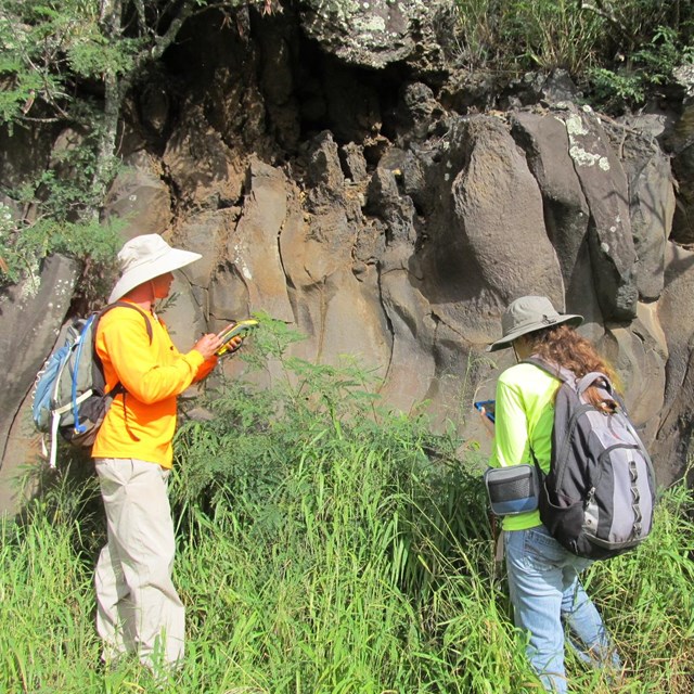
Along the Kūloa Point and Pīpīwai Trails you can see evidence of the Kīpahulu coastal village as well as evidence of each layer of human occupation:
  1. Pā hale: the foundation of living quarters that would have been part of a larger kauhale (house complex). Evidence of walls show this kauhale extended mauka into the forest. The small square house site right off the Kūloa Point Trail is that of a hale noa, or a sleeping house.
  2. Rock walls: Viewing is most evident behind the reconstructed Hale Hālāwai and along Kūloa Point. These walls represent all eras of Kīpahulu occupation: pre-Contact, the Mahele, sugar plantation times, ranching, and the National Park Service. Often walls were reused throughout multiple time periods. Rocks walls are common throughout the Hawaiian islands and are used for many things: animal enclosures; lo‘i kalo (irrigated taro) terraces; house complexes; features of heiau (Hawaiian temples); and ahupuaʻa (or land divisions) markers. Rock walls in Hawaiʻi are made by skillful and strong experts, carefully stacking rocks—no mortar is used.
  3. Koʻa (Fishing shrine): Kīpahulu has plentiful marine resources and is home to the god Laka, who is worshipped by canoe makers. One of the most famous canoe makers of old times, was Lulana from Kīpahulu. Fishing shrines are ahu (carefully placed rock stacks) that are built to mark a fertile fishing area. Appropriate offerings, often the first catch, were left to ensure a good harvest.
  4. Kanekauila heiau: Heiau (temples) were built to honor different dieities or chiefs and each served a specifici purpose in the lives of the people who resided in that ahupuaʻa. Kanekauilia heiau aligns to Moʻokini heiau on Hawaiʻi island. It is thought to be a navigational guide across Alenuihāhā Channel. Kanekauila is partially on NPS managed lands, and partially on lands managed by the State of Hawaiʻi and the Catholic Church.
 
kipahulu moku map
Map of Kīpahulu Moku

"Sites of Maui" by Elspeth P. Sterling, published in Honolulu in 1998 by Bishop Museum Press.

Additional sites in Kīpahulu:

Further inland in the forested region and along NPS trails are plentiful loʻi kalo (irrigated taro terraces), animal enclosures or garden walls, and house sites. Combined, these sites help Haleakalā National Park to understand how populous Kīpahulu was before it was impacted by Western contact, development and disease. La Perouse, who did not land in Kīpahulu but sailed past in 1786, stated in the first written description of Kīpahulu,

“I coasted along its shore at a distance of a league (2.5 miles)...we beheld water falling in cascades...the inhabitants, which are so numerous that a space of 3-4 leagues may be taken for a single village. The huts are on the coast so that the habitable part of the island is less than half a league.”
 
Kalo growing
Kalo terraces at the Kapahu Living Farm

NPS Photo

Restoring loʻi kalo:

The Kīpahulu ʻOhana has done the laborious and important work of restoring ancient loʻi kalo at Kapahu Living Farm, in the Kīpahulu District. As part of their work restoring the moku of Kīpahulu, they cultivate kalo for the wider Kīpahulu and Hāna community and educate the community on traditional subsistence practices from mauka to makai. Former Superintendent Don Reeser was instrumental in forming the cooperative agreement between the park and the Kīpahulu ʻOhana.
 

Last updated: November 30, 2022

Park footer

Contact Info

Mailing Address:

Haleakalā National Park
PO Box 369

Makawao, HI 96768

Phone:

808 572-4400

Contact Us

Tools