
Joshua Jones photo Start at the Sugarlands Visitor center where you can pick up a free park map and newspaper, watch the free 20-minute park film or walk through the museum.
Park rangers are available to answer your questions. The bookstore carries a wide array of books, maps, guides, and other items to make your trip to the park memorable.
Waterfalls
Visiting a waterfall is one of the park’s most popular activities. Due to that popularity, parking at the trailheads can be limited during peak visitation during the summer and on weekends.

NPS Photo Cataract Falls
The walk to Cataract Falls begins at Sugarlands Visitor Center, so it is a great start to get those legs working once you get out of the car.
Located just behind Sugarlands Visitor Center, This 0.7-mile forested trail takes you to the 40-foot Cataract Falls. Exiting the visitor center, take a right and go past the public restrooms and follow the side walk to the Fighting Creek Nature Trail on the left.
Walking along this trail, you will pass tree identification markers that highlight the various types of trees of the area. You will cross a creek on a footbridge bedside a large and uniquely shaped sycamore tree. After the bridge, the trail goes right to the waterfall.
If you wish to walk farther, return to the footbridge that you crossed, but continue straight past it to the nature trail, a 1-mile long loop that goes to the John Ownby cabin and returns you back to the footbridge. A walk on the loop trail will add an additional 30 minutes to your trip.
•Hiking time: 30 minutes to 1 hour
•Suggested combinations: Laurel Falls, Tour Roaring Fork Motor Nature Trail, picnic at Chimney tops
Grotto Falls
The 25-foot waterfall is located on the Trillium Gap Trail, which is just off the Roaring Fork Motor Nature Trail. The cave like sandstone formation of the rock gives the waterfalls its name. The trail to the waterfalls is a popular one to see a diversity of plant and animal life. Hemlocks, tulip poplars, and flowering dogwoods line the trail. Enjoy the opportunity to be able to walk behind the waterfall.
•Driving time from Sugarlands: 10 minutes
•Hiking time: 2 hours
•Suggested combinations: Roaring Fork Motor Nature Trail
Hen Wallow Falls
Located in the Cosby area of the park, this 95-foot waterfall lies just off the Gabes Mountain Trail. It is a 4.4-mile roundtrip to the waterfall walking through a forest canopy of hemlock and rhododendron. The forest in the area was not heavily logged in the pre-park day, so an impressive old-growth forest lies beyond the waterfall.
•Driving time from Sugarlands: 45 minutes
•Hiking time: 3-4 hours
•Suggested combinations: Roaring Fork Motor Nature Trail, Cosby Picnic area
Auto Touring
With over 270 miles of road in the National park that can take you to panoramic views and some of the most diverse forest systems in the world, take the opportunity to venture outside the car and enjoy a stroll to some newly found experience.

Bob Carr photo Roaring Fork Motor Nature Trail
This nature trail offers visitors an opportunity to travel back in time to an era of tub mills, homesteads and corncribs.
Understand this self-sustaining life surrounded by a natural world of waterfalls and the streams that fed them.
Find the relationship between the homesteader and the land by visiting the home sites around the motor trail. Listen to the sound of the rivers and feel the coolness of the falls at “Place of a Thousand Drips”, or take a hike to Grotto Falls.
•Driving time from Sugarlands: 30 minutes
•Touring time: 1 hour, allow additional time to visit the home sites
•Suggested combinations: Grotto falls, touring the historic homes add 1 additional hour
Kuwohi
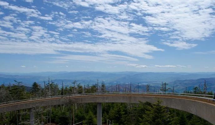
Kristina Plass photo The scenic drive up the mountains to Newfound Gap and Kuwohi offers multiple pullouts to enjoy the views of the mountainsides. As you drive from low elevations to high, you will be travelling through diverse forest ecosystems that duplicate taking a drive from Georgia to Maine.
Kuwohi is the highest point in Tennessee. An observation tower will give you 360˚ degree views of the valleys and ridges of the Great Smoky Mountains. The paved trail is a short, but steep. Benches along the way offer a chance to rest and catch your breath.
• Driving time from Sugarlands: 45 minutes
• Hiking time: 1 hour
• Suggested combinations: Chimneys Picnic area, Newfound Gap
Cades Cove

Kristina Plass photo One of the most visited places in the Great Smokies Mountains National Park is the 11 mile, one-way loop around Cades Cove.
The area encompasses the abundance of both the natural and cultural resources of the national park.
Over 16 original historic structures still stand today representing the time in which some of the first European settlers worked and lived.
Short trails from the road give access to these home sites. The natural surrounding is a common place to see a diversity of wildlife including deer, turkeys and bears.
• Driving time from Sugarlands: 1 hour
• Touring time: 2-4 hours
• Suggested combinations: Laurel Falls, Metcalf Bottoms picnic area, touring the historic homes add 1 additional hour
Hiking
In addition to the multiple waterfalls hikes you can take in Great Smoky Mountains National Park, here are some other options to get out and explore the park.
Kristina Plass photo
Chimney Tops Trail
One the more popular hikes in the park due to its distance and mountain views, this trail takes you through one of the most diverse forest ecosystems in the world and a top some of the oldest rock of the area. There is over a 1400-foot gain in 2 miles to reach the top of the metamorphic slate that is, “Chimney Tops”. With multiple stream and bridge crosses, it is the last 35 feet of polished slate that is most concerning for those who want to get a better view. Extremely hazardous in inclement weather, the additional climb to the summit, we encourage extreme caution.
• Difficulty: Moderate to Strenuous
• Driving time from Sugarlands: 25 minutes • Hiking time: 3 hours
• Suggested combinations: Chimney Tops picnic area, Newfound Gap, Clingmans Dome
Charlies Bunion
Located on the backbone of the Appalachian Mountains, this destination offers some of the most scenic mountain views along the Appalachian Trail. A continuous trail that runs from Georgia to Maine, to reach Charlies Bunion is a roundtrip 8-mile trek along some of the higher elevations in the park. Most people access the trailhead from the Newfound Gap parking area where in just minutes you will escape the crowds, immersed in a natural landscape.
• Difficulty: Strenuous
• Driving time from Sugarlands: 40 minutes
• Hiking time: 5 hours
• Suggested combinations: Chimney Tops picnic area, Newfound Gap, Clingmans Dome
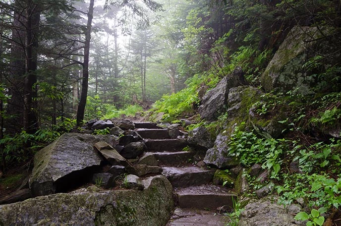
Alum Cave
One of the most diverse trails in the park, the hike to the Alum Cave Bluffs is an opportunity to walk through old growth forests, cross cool mountain streams, and bear witness to the unique geological formations of Great Smoky Mountains National Park. Some of these features, Arch Rock is just 1.4 miles from the trailhead and allows you to walk through the rock outcropping. Continue on to the Alum Cave Bluffs and be rewarded by some of the best views in the smokies. The roundtrip distance to the bluffs and back is 5 miles. For those with a longer day and stronger endurance, you can continue on the trail to summit Mt. LeConte to make the roundtrip at a ten-mile trek.
• Difficulty Moderate to Strenuous
• Driving time from Sugarlands: 40 minutes
• Hiking time: 4 hours
• Suggested combinations: Chimney Tops picnic area, Newfound Gap, Clingmans Dome
In today’s world of grab and go dining, the traditional picnic is still a great way to be able to enjoy the pleasant experience of the sounds of a river or the shade of the trees.
Chimney Picnic Area
Located off Newfound Gap Road between the Sugarlands Visitor Center and Clingmans Dome, this picnic resides in a Cove Hardwood Forest. At about 4500 feet, this type of forest has the most diversity of trees in the park. Examples of these wonderful trees are seen on the Cove Hardwood Nature Trail, a self-guiding nature trail that is just a ¾-mile loop. During the spring, this trail is one of the recognized trails to view wildflowers in the park.
• Driving time from Sugarlands: 15 minutes
• Hiking time: 45 minutes
• Suggested combinations: Newfound Gap, Clingmans Dome

Kent Cave photo Located half way between Sugarlands Visitor Center and Cades Cove, Metcalf Bottoms is a picnic area that resides along the Little River.
The picnic area is open year round and a great place to take the entire family for a mid-day lunch.
After lunch, a great option is to hike the 1.2 miles to the Little Greenbrier School and Walker Sisters cabin.
Walking the trail will give you better understanding of what life was like for the people of these mountains.
• Driving time from Sugarlands:
• Hiking time: 2 hours • Suggested combinations: Laurel Falls
Cosby Picnic Area
Considered an out-of-the-way area of the National Park, Cosby has numerous opportunities to take advantage one of the more insulated places of Great Smoky Mountains National Park. The picnic area is a spacious area that is rarely full and there are multiple activities to go out after lunch and burn off those calories. At the top of the picnic area across from the campground ranger station, a trail leads to the to the Cosby Nature trail. A short loop around Cosby Creek, the trail is nice stroll through a gentle forest.
• Driving time from Sugarlands: 45 minutes
• Hiking time: 35 minutes
• Suggested combinations: Roaring Fork Motor Nature Trail, Hen Wallow Waterfall
|
Last updated: March 11, 2025