
Bob Carr photo.
Details about taking this hike: Trail: Appalachain Trail Driving to the Trailhead: Drive on Newfound Gap Road to Newfound Gap parking lot which is 13.2 miles from Sugarlands Visitor Center or 16 miles from Oconaluftee Visitor Center. The trailhead is to the left of the overlook, at the end of the parking lot near the restrooms. Hiking Distance: 4.0 miles one way to Charlies Bunion Trail Conditions:Elevation change of 1,600 feet; this is a firm-packed trail that traverses some exposed cliffs. Notes: The Appalachian Trail heads out in two directions from Newfound Gap - one way towards Clingmans Dome and one way towards Charlies Bunion. The trail aslo continues beyond Charlies Bunion and goes all the way to Mt. Katahdin in Maine. Pets are not allowed on this trail. The only two trails in the park that allow pets are the Gatlinburg Trail near the Sugarlands Visitor Center and the Oconaluftee River Trail near the Oconaluftee Visitor Center. Learn more about pet restrictions in the park. 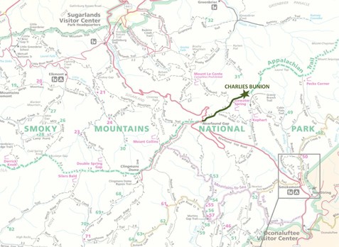
|
Last updated: August 3, 2015