An official website of the United States government
Here's how you know
Official websites use .gov A
.gov website belongs to an official government
organization in the United States.
Secure .gov websites use HTTPS A
lock (
) or https:// means you've safely connected to
the .gov website. Share sensitive information only on official,
secure websites.
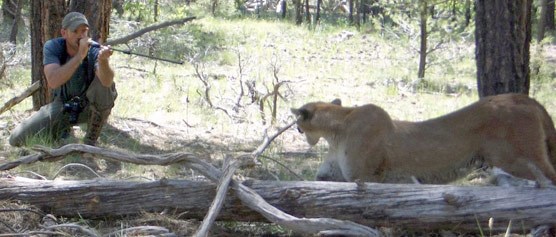
The mountain lion research conducted by Eric York prior to his tragic death in November 2007 has significantly added to our knowledge of this keystone predator in Grand Canyon National Park. Thanks to his efforts, we now know the size, shape and location of numerous mountain lion home ranges within the park. We know where mountain lions continually cross dangerous paved roads within the park. We know at what time of day and in which seasons the greatest number of road crossings takes place. We know the mortality rate and the causes of death in our lion population. We know what their prey base is and we know where they cache their kills. All of this information, collected through the hard work and devotion of Eric York, is used by park management to ensure the continued survival of mountain lions within the park. This article presents a summary of how this information was acquired and of the results of some of Eric’s work.
Radiotelemetry Lion Study In 2003, National Park Service biologists at Grand Canyon National Park initiated a radiotelemetry study of mountain lions in and around GCNP. Methods included using both very high frequency radio signals and global positioning satellite technology to acquire accurate location information from collared mountain lions. Investigation of GPS locations allows biologists to gather information about lion behavior, including predation habits, reproductive activity, habitat selection, intraspecific interactions and interactions with other carnivores.
Eric York’s consummate skill and experience in tracking and trapping mountain lions elevated a small pre-existing study involving track counts and scent posts to a more detailed and in-depth study of mountain lion behavior in the rugged environment of Grand Canyon.
Objectives of the study included:
1. Determining behavior patterns of mountain lions that utilize human-populated areas. 2. Documenting mountain lion prey composition and predation rates. 3. Determining impacts of features such as highways, human developments and artificial water sources on mountain lion behavior. 4. Analyzing effects of human activities on the mountain lion population.
Mountain lions were captured with Aldrich-type foot snares using standard methods and equipment for trapping lions. A total of 127 traps were set along game trails, ridge lines, canyon walls and other common lion travel routes. At any one time, up to 25 traps were set from 1- to 50-day periods, year-round, depending on personnel availability and weather conditions. Traps were checked twice daily — visually in the morning near sunrise, and again in the afternoon either visually or by capture activated transmitter on the trap. Traps were closed during periods of extreme weather.
Captured mountain lions were immobilized with a mixture of tranquilizer chemicals, delivered via blow dart. Immobilized lions were fitted with GPS/VHF radio collars and were weighed, and morphological measurements were taken. Blood was collected for genetic analysis. All capture methods and drugs used were approved by National Park Service veterinarians. Collars were programmed to acquire 8 to 12 locations per day 6 days a week and 24 locations on Saturdays. Each download of data, which occurred approximately every 60 days, consisted of 500 to 1,000 GPS locations.
Home Ranges Nine individual mountain lions were captured between late 2003 and August 2006. Four (two male, two female) adult resident lions were tracked for more than 11 months to determine home range size and location in the GCNP study area. Another male’s (P01) home range was calculated after dispersing out of GCNP south to the Coconino National Forest just north of Flagstaff.
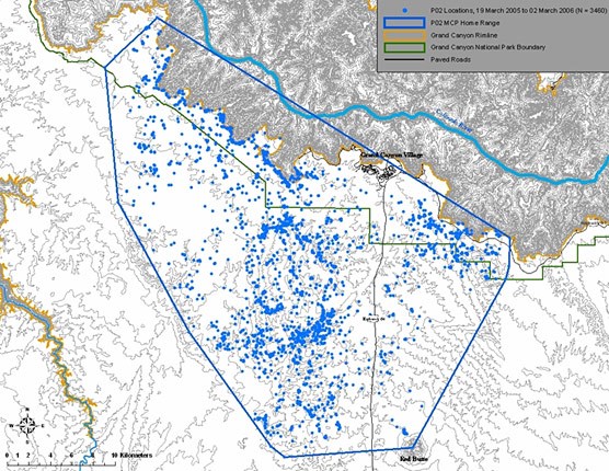
The illustration below shows the home range of P02, a female that was legally hunted and taken outside the park in March 2006. As expected, males had larger home ranges than females and traveled extensively through several female ranges. Home range size varied from 322 to 480 square kilometers (124 to 185 square miles) for males, and 198 to 445 square kilometers (76 to 172 square miles) for females. Although most of the radio-collared cats had GPS locations less than one kilometer (0.6 mile) from the developed areas of Grand Canyon Village, no mountain lions were located directly in the developed areas. There were no lion/human interactions with collared lions during the study. The only human interactions with the mountain lions were at the time of the lions’ deaths, either by vehicle collision or hunting.
Locations of P02 and her known range on Grand Canyon's South Rim.
nps map
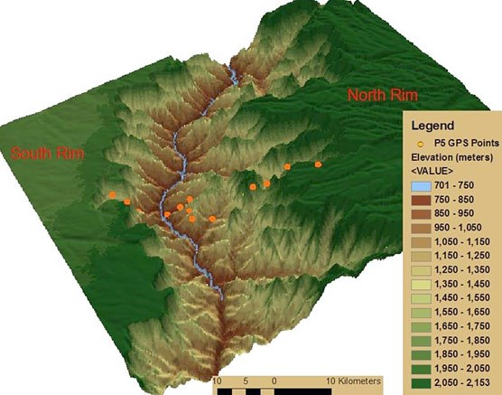
Dispersal The extreme vertical structure of the Grand Canyon represents a formidable barrier to large mammal movement. In addition to the limited access into the canyon, the Colorado River represents a constant obstacle for crossing the canyon. Resident adult mountain lions on the South Rim of the canyon use the rim as a distinct territory boundary. Research found very little use of the canyon by lions, except areas just below the rim that were often used for short periods of resting during the day. The ledgy Kaibab and Toroweap formations provide ample resting sites for lions.
Only one mountain lion (P05), a young female, traveled into and across the canyon.(see illustration above) This lion dropped off the South Rim, swam the Colorado River and climbed to the North Rim in the space of eight hours. The other dispersing lion (P01), a young male, traveled along the rim before dispersing approximately 70 kilometers (40 miles) south to the San Francisco Peaks area, just north of Flagstaff.
Mountain lion P05 was tracked as she crossed the canyon.
NPS Illustration.
Survival To determine mountain lion mortality causes and rates, radio collars are equipped with a mortality sensor. The sensor is activated by six hours of immobility, typically much longer than a mountain lion would rest. Once the sensor is activated, the VHF signal of the radio collars quickens to alert a biologist of the mortality (or the detachment of the collar). Annual survival rates of collared lions were calculated using the computer program Micromort . Eight collared mountain lions were tracked for 8 to 408 days. Of these, four animals have died. All deaths have been human-caused. Two lions (P01 and P02) were killed by hunters outside of GCNP, and two (P06 and P08) were killed by cars inside the park. Survival rates for males and females were 0.65 and 0.56, respectively. In other words, an individual lion had a 65 percent or 56 percent chance of survival for the length of the study, depending on the lion’s gender.
Of the eight radio-collared mountain lions tracked, seven crossed the major paved roads in the park. Home ranges of three adult lions (males P02 and P04, and female P06) encompassed sections of Arizona Highway 64 south of and into the park, including Desert View Drive. The three transient younger mountain lions also crossed Desert View Drive. The sites where P06 and P08 were killed by cars are located less than 1,000 feet apart on Desert View Drive, near mile marker 250. Prior to this study a lion was also killed in March 2003 in this same area by a bus contracted by the National Park Service.
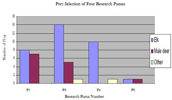
Mountain Lion Prey Use To locate prey killed by mountain lions, lion GPS locations were mapped using a geographic information system. Mountain lion location clusters (many GPS points over a small area) were identified visually. Clusters, usually less than 300 square meters (3,200 square feet), consisting of multiple points over a long period (more than six hours) were investigated in the field. Prey items (bones, hair, rumen) found at mountain lion GPS clusters were identified and aged.
Of the kill sites examined, elk (most less than one year old) were the most common prey. Deer were the second most common. Other prey species included coyotes and bobcats.
Future Work This summary encompasses work conducted by Eric York from 2003 until August 2006. During 2007, Eric continued to trap and radio-track mountain lions. During one brief period in the summer, Eric was tracking 10 mountain lions with functioning collars. The data collected during this period are currently being analyzed by GCNP’s Division of Science and Resource Management wildlife staff, and additional reports will be forthcoming. Three cats with functioning GPS collars still roam Grand Canyon’s South Rim, and their location information is stored in their GPS collars. In spring 2008, this data was downloaded and added to Grand Canyon’s growing database of mountain lion behavior and ecology.
Currently, a moratorium has been placed on capturing mountain lions in GCNP. It is hoped that after the National Park Service develops safeguards to ensure the safety and health of wildlife researchers in the park, Eric’s work can be continued.