|
Visit our keyboard shortcuts docs for details
Have you ever wondered how the Grand Canyon was formed and why it is found here in Northern Arizona? To understand the formation of the canyon, there is a simple way to remember how it was shaped over time. All you have to remember are the letters D U D E or dude. The letters stand for: Deposition, Uplift, Down cutting and Erosion. A distinct and ordered combination of geologic events.The story begins almost two billion years ago with the formation of the igneous and metamorphic rocks of the inner gorge. Above these old rocks lie layer upon layer of sedimentary rock, each telling a unique part of the environmental history of the Grand Canyon region. Then, between 70 and 30 million years ago, through the action of plate tectonics, the whole region was uplifted, resulting in the high and relatively flat Colorado Plateau. Finally, beginning just 5-6 million years ago, the Colorado River began to carve its way downward. Further erosion by tributary streams led to the canyon’s widening. Still today these forces of nature are at work slowly deepening and widening the Grand Canyon. 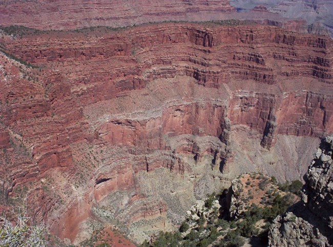
Rock depositionThe story of how Grand Canyon came to be begins with the formation of the layers and layers of rock that the canyon winds through. The story begins about 2 billion years ago when igneous and metamorphic rocks were formed. Then, layer upon layer of sedimentary rocks were laid on top of these basement rocks. To look at rock layers, geologists use a diagram called a stratigraphic column. It shows the rock layers with the oldest on the bottom, and the youngest on the top. That means that the bottom layer was formed first, and every subsequent layer was formed later, with the youngest rocks on the top. In geology, this is referred to as the principle of superposition, meaning rocks on the top are generally younger than rocks below them. Another important principle is the principle of original horizontality. This means that all the rock layers were laid horizontally. If rock layers appear tilted, that is due to some geologic event that occurred after the rocks were originally deposited. 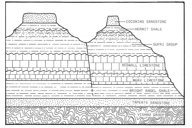

Colorado Plateau upliftThe Kaibab Limestone, the uppermost layer of rock at Grand Canyon, was formed at the bottom of the ocean. Yet today, at the top of the Colorado Plateau, the Kaibab Limestone is found at elevations up to 9,000 feet. How did these sea floor rocks attain such high elevations? Uplift of the Colorado Plateau was a key step in the eventual formation of Grand Canyon. The action of plate tectonics lifted the rocks high and flat, creating a plateau through which the Colorado River could cut down. The way in which the uplift of the Colorado Plateau occurred is puzzling. With uplift, geologists generally expect to see deformation of rocks. The rocks that comprise the Rocky Mountains, for example, were dramatically crunched and deformed during their uplift. On the Colorado Plateau, the rocks weren’t altered significantly; they were instead lifted high and flat. Just how and why uplift occurred this way is under investigation. While scientists don’t know exactly how the uplift of the Colorado Plateau occurred, a few hypotheses have been proposed. The two currently favored hypotheses call for something called shallow-angle subduction or continued uplift through isostacy. Scientists have observed that the angle of subduction directly affects the landscape on the South American continent. Where normal angle subduction is occurring, active volcanoes form. Where shallow-angle subduction is occurring, there are no volcanoes. Instead, blocks of crust are uplifted along reverse faults.
The Rocky Mountains and the Colorado Plateau are thought to have similarly uplifted along reverse faults in North America. The story of uplift certainly begins with plate tectonics and very likely a mountain building episode called the Laramide Orogeny. The Laramide Orogeny began about 70 million years ago during the Mesozoic Era, and lasted until about 40 million years ago in the Cenozoic Era. During that time, some scientists hypothesize that the subduction of the Farallon Plate on the western edge of North America changed. Instead of subducting at the usual steep angle, the Farallon Plate probably subducted at a shallower angle and a faster rate. Shallow-angle subduction allowed for deformation to move further inward from the plate margin – about 625 miles. The intense East-West compression of the two plates brought about the uplift of the Rocky Mountains as well as the Colorado Plateau. For a modern day example of shallow-angle subduction we look to the western edge of South America. There, the Nazca Plate has split. One part of the plate is subducting at a normal angle, while another subducts at a shallow angle. Whether or not the Colorado Plateau reached an overall high elevation at the end of the Laramide Orogeny isn’t certain. Some scientists believe that uplift of the Colorado Plateau continued into the middle to late Cenozoic. If this is indeed true, continued uplift can be explained in part by isostatic rebound.
To understand isostatic rebound it may be helpful to do a little experiment. Have a friend hold your arms tightly against your side while you push back as hard as you possibly can. Hold this posture for about 30 seconds and then stop pushing. Ask your friend to let go. What happened to your arms once the pressure was released? Did they feel light-weight, as if they wanted to lift away from your sides? Earth’s crust responds similarly. When significant amounts of material are removed by erosion, the crust rises up. This rising of the crust after the release of pressure is called isostatic rebound. What is a Valley? What is a Canyon?A valley is a landform characterized by a low-lying area of land surrounded by high areas, such as mountains or hills. Valleys can be a wide variety of shapes and sizes. They are either erosional features, carved by water or glacial ice, or structural features, caused by rifting. A canyon is a type of erosional valley with extremely steep sides, frequently forming vertical or nearly vertical cliff faces.The term “gorge” is often used interchangeably with “canyon” and generally implies a smaller, particularly narrow feature. Grand Canyon is perhaps the best example of a water-carved canyon. Water has tremendous erosive power, particularly when carrying large amounts of sediment and rock, like the Colorado River does when flooding.
Other conditions are also necessary for carving a canyon like Grand Canyon, which you can explore further in the Downcutting and Erosion section of this web site. Unless these other conditions are met, rivers carve valleys. Glaciers can change large areas of land by abrasion, a scraping action, and plucking, a lifting action. Abrasion occurs when sediment and rock are frozen to the bottom and sides of the glacier. As the glacier moves, the rocks and sediment grind and scrape the rock surfaces over which the ice flows.
The rock surfaces are gradually worn down much like wood is worn down by sandpaper. The glacier scours the landscape and leaves behind large gouges, small striations, or even a finely polished surface. Glaciers can also pluck or lift large chunks of rock. These rocks are then frozen into the glacier and also abrade the rock over which the glacier travels. Mountain glaciers create U-shaped valleys by plucking and scouring. To learn more about glaciers, check out the glacier knowledge center in Views of the National Parks. Glaciers never existed in or near Grand Canyon, however they have existed and may still exist today in other National Parks. Many examples of U-shaped glacial valleys can be seen in the National Parks, such as Yosemite National Park in California. A rift valley is created when two plates of Earth's crust pull apart. Plates pull apart along divergent plate boundaries. The Mid-Atlantic Ridge, which is located in the center of the Atlantic Ocean, forms a very large rift valley on the ocean floor. This rift valley is forming as Africa and South America spread apart from each other.
Not all rift valleys are located underwater. Rifting can also happen on land, forming rift valleys such as The Great Rift Valley in Africa or the Rio Grande Rift here in North America. The Rio Grande Rift runs south to north from the state of Chihuahua, Mexico, to Leadville, Colorado. It began forming between 30 to 35 million years ago and continues to widen very slowly today. Rifts like the Rio Grande form basins, or valleys, that slowly fill with sediments. In Albuquerque, New Mexico, which is situated in the Rio Grande Rift, these basin sediments have reached a thickness of three miles. 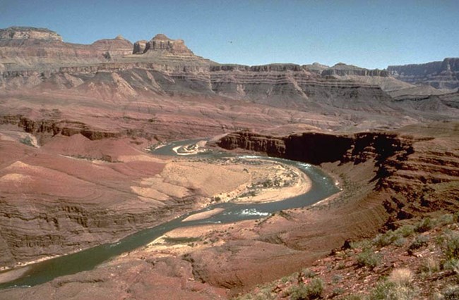
How did the Colorado River carve such a big canyon?The Colorado River has been carving away rock for the past five to six million years. Remember, the oldest rocks in Grand Canyon are 1.8 billion years old. The canyon is much younger than the rocks through which it winds. Even the youngest rock layer, the Kaibab Formation, is 270 million years old, many years older than the canyon itself. Geologists call the process of canyon formation downcutting. Downcutting occurs as a river carves out a canyon or valley, cutting down into the earth and eroding away rock. Downcutting happens during flooding. When large amounts of water are moved through a river channel, large rocks and boulders are carried too. These rocks act like chisels, chipping off pieces of the riverbed as they bounce along. Several factors increase the amount of downcutting that happens in Grand Canyon: the Colorado River has a steep slope, a large volume, and flows through an arid climate. Gradient is a measure of slope. The higher the gradient, the steeper the slope. If you go sledding, a steeper slope means a faster ride down the hill. For riverbeds, a high, or steep, gradient means a faster current.
A river with a faster current has the power to carry larger rocks and boulders. While a steep gradient is not an uncommon characteristic of rivers, it is certainly an important one, adding to a river’s power. On its 277 mile (446 km) journey through Grand Canyon, the Colorado River descends about 2,000 feet (610 m) in elevation. For a river this is a steep slope, which gives the river a tremendous amount of speed and the ability to transport big rocks during floods. That is, there is a lot of water flowing in the Colorado River. A river with a large volume can carry a lot of sediment.
Compared with the volume of rivers like the Mississippi or the Nile, the volume of the Colorado is pretty small. But, during floods, its volume increases significantly. The Colorado River through Grand Canyon averages 300 feet (91 m) across and about 40 feet (12 m) deep. The average flow is between 12,000 and 15,000 cubic feet per second (cfs). During a flood, the increased volume of water can flow at a rate of 300,000 cubic feet per second (cfs). Imagine 300,000 basketballs, each about the size of a cubic foot, barreling past you each second! Some geologists suggest that when glaciers were melting in the Rocky Mountains at the close of the last ice age, there might have been as much as one million cfs moving through the Colorado River’s channel. Mechanical weathering happens relatively quickly in arid regions. In more humid regions, plants cover the land and help slow erosion. In arid climates, there is often very little soil, leaving bedrock exposed.
The exposed rocks are more easily eroded by precipitation, daily fluctuations in surface temperature, and ice-wedging during winter months. Rivers flowing through arid landscapes can carve through rock more easily because the rock is exposed and weathered. 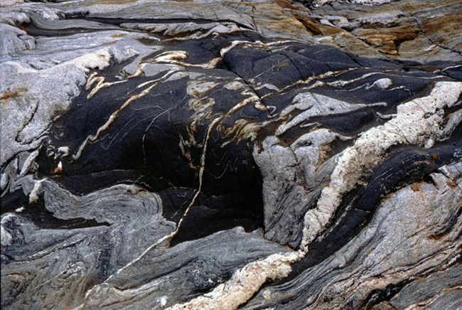
A dynamic placeWeathering and erosion are ongoing processes. If we were to visit Grand Canyon in another couple million years, how might it look? For one, it would be wider; we may not even be able to see across it anymore. Much of Grand Canyon’s width has been gained through the erosive action of water flowing down into the Colorado River via tributaries. As long as water from snow melt and rain continues to flow in these side drainages, erosion will continue. In a few million years, Grand Canyon also may be a bit deeper, though the canyon isn’t getting deeper nearly as fast as it is getting wider. The rocks through which the river is currently downcutting are hard, crystalline igneous and metamorphic rocks, which are much stronger than the sedimentary rocks resting above them. More importantly, the river’s gradient has decreased, such that it has less power to battle with the hard rocks. Finally, the river’s elevation near Phantom Ranch, a popular hiking destination in the canyon, is just 2,400 feet above sea level. Because sea level (0 ft.) is the ultimate base level for all rivers and streams, upon reaching sea level, the Colorado River will be done downcutting. Currently controlled by Glen Canyon Dam, the Colorado River through Grand Canyon no longer experiences dramatic changes in water volume throughout the year.
Prior to the construction of Glen Canyon Dam, the volume of flow of the Colorado River would decrease to as low as 500 – 1000 cfs in late summer. Then, in late spring when snows in the Rocky Mountains were melting, the river would swell to 100,000 cfs or more. In the past, downcutting occurred during these spring floods because the flood waters could carry tremendous amounts of sediment and had the power to sweep huge rocks downstream. The highest recorded pre-dam flow was about 300,000 cfs in 1884. The highest recorded post-dam flow of just 92,400 cfs was in 1983. Much of Northern Arizona is dotted with cinder cones, lava domes and stratovolcanoes. The San Francisco Volcanic Field, which contains at least 600 cinder cones, covers 1,800 square miles. Standing at about the center of this vast volcanic field are the prominent San Francisco Peaks of Flagstaff, Arizona, remnants of a geologically young stratovolcano.
Cinder cones are also found near the western end of Grand Canyon, between Toroweap Valley and Hurricane fault. Beginning about 630,000 years ago, lava cascaded over the canyon’s North Rim from volcanoes such as Vulcan's Throne, damming the river at least 13 times. One such lava dam was over 2,000 feet high, reaching several hundred feet higher than Glen Canyon Dam does today. Because these dams were not particularly strong, they were probably very short lived. One thing we can be sure of is that the lava dams were removed by the erosive action of the Colorado River. Once water pooled enough to pour over the top of the dams, a phenomenon called “spillover” or “overtopping,” the river was able to quickly erode through the obstacle. Evidence of huge outburst floods has been well documented in western Grand Canyon. Finally, about 400,000 years ago, volcanic eruptions came to an end, and the river was temporarily blocked for the last time. Numerous normal faults cut across Grand Canyon. Normal faults form in response to extensional tectonics or in other words when a region is being slowly pulled apart, eventually resulting in a landscape such as Nevada’s basin and range.
The most active faults in northwestern Arizona are the Hurricane and Toroweap faults, which cut across Grand Canyon near river miles 179 and 191. Significant offset can be observed along these faults, which have moved vertically between 520 and 720 feet in the past 2 million years. Ruptured rock layers are also common in this stretch, offering evidence for the occurrence of major earthquakes. Learning more about these faults is exciting because they help scientists determine just how fast the Colorado River is downcutting. 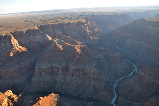
How old is Grand Canyon and the Colorado River?Landscapes are more difficult to date than rock formations. Still, by looking at relationships between rock formations, scientists are able to determine ages of landscapes with some precision. Scientists have used this type of relative dating technique to narrow the age of the Colorado River and Grand Canyon. Scientists know that the Colorado River carved Grand Canyon. The river is thus slightly older than the canyon, though the two are certainly close in age. Scientists have studied rock deposits along course of the present day Colorado River. By looking at the type of sediments the deposits contain, scientists determine whether or not the rocks were deposited by the river. Rocks deposited by the river are younger than the river, as the river needed to be around to deposit them. Rocks not deposited by the river are older than the river because the river was not yet there to drop them. When possible the scientists then date these rock deposits. The age of the river falls between the rocks determined to be older than the river and those determined to be younger. Through this method, scientists have estimated an age for the river, and thus the canyon through which it flows, of 5-6 million years. The Hualapai Limestone was deposited in a warm, shallow freshwater lake just west of the Grand Wash Cliffs. It does not contain any river sediments, therefore, the Colorado River was not flowing yet when the Hualapai Limestone was deposited.
The estimated age of the Hualapai Limestone is 6 million years. It was obtained from the Fortification Basalt, a lava flow that is interbedded with the sediments. Because the Hualapai Limestone is older than the river, the river can’t be more than 6 million years old. Directly below the Sandy Point Basalt rests a Colorado River gravel deposit. The river was therefore present and flowing before the basalt was deposited.
The Sandy Point Basalt is 4.4 million years old, which means that the river is at least that old. The quartz-rich sands and silts of the Bouse Formation are found in just three basins along the modern Colorado River. Scientists believe that these sediments came from the Colorado River, though their precise depositional environment is debated. Some believe the Bouse Formation was deposited in an estuary, while others claim that deposition took place in a series of freshwater lakes fed by the Colorado.
The water in both of these possible environments would have been from the Colorado River. Therefore, the river was already flowing about 5 million years ago. The Imperial Formation is composed of both marine and deltaic sediments, meaning that it was deposited at the mouth of a river on a delta that was sometimes covered by the sea. Colorado River sediments are found in this formation.
In particular, the Imperial Formation contains microfossils from rock layers on the Colorado Plateau. The Colorado River, then, must have been carrying eroded rock materials from the Plateau to its mouth by 5 million years ago. The opening of the Colorado River’s outlet, the Gulf of California, was a significant event in the story of Grand Canyon. It was this event that allowed for the establishment of the modern, through-flowing Colorado River. Connecting the Colorado River of the Colorado Plateau with an outlet to the sea lowered the base level by about 5,000 feet (1,524 m). The base level is the lowest level to which a river can erode its bed. The ultimate base level is sea level (0 ft.).
The introduction of this lower base level created the conditions necessary for incision through the Colorado Plateau to occur. 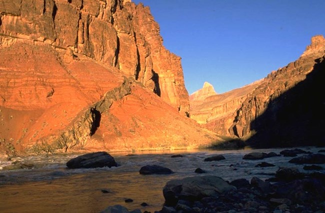
How did the Colorado River and the canyon come to be?It is fairly easy to explain the formation of Grand Canyon through downcutting, weathering, and erosion. It is more difficult to explain just how the Colorado River came to be in its current location. We can think of the development of the Colorado River as a history book with many chapters. The most recent chapter is familiar, because it is the chapter that is visible today. But, there are a number of chapters missing. The plotlines of some of those missing chapters are heavily debated. There are a few chapters in the story that the majority of geologists agree upon. For one, evidence collected thus far suggests that the upper and lower reaches of the Colorado River are different ages. The lower section in California, Nevada, and Arizona is younger than the upper portion in Utah and Colorado. The age of the younger portion of the river is estimated to be between 5 and 6 million years based on the various constraints listed in the Ages section. The older portion, or “ancestral Colorado River,” is at least 7 million years old and may even be 10 million years old, based on the presence of river gravels found near Grand Junction, Colorado. When the upper and lower portions combined, an event called drainage integration, the Colorado River became what it is today. In other words, the river that we know today as the Colorado River, was actually once either two different rivers that have been joined together or a much shorter river that was later lengthened. Another widely accepted chapter in the Colorado River’s history book is that the landscape of the Colorado Plateau and surrounding areas looked very different at the time that the Colorado River developed. We know younger rocks once rested on top of the Kaibab Limestone because of land forms such as Red Butte south of Grand Canyon, which is composed of some of these younger rock layers. The majority of these rock layers, however, have been eroded away. We can only guess what the landscape might have looked like, but it is likely that this unknown topography influenced the present course of the river. Today, the Kaibab Plateau, a high point through which the river gingerly slices, poses a problem for geologists. Water certainly doesn’t flow up hill, so geologists hypothesize that at the time the river started cutting through it, the Kaibab Plateau must not have been an obstacle. It may have been smaller 10 to 30 million years ago, or perhaps it was buried beneath layers of flat-lying Mesozoic rocks, only to be revealed after the river had already established its course. While keeping these few accepted chapters in the Colorado River’s history book in mind, geologists have proposed a number of different hypotheses to explain how the river became a through-flowing river with an outlet at the Gulf of California. As we learn more, some hypotheses may be confirmed or proven false. Regardless, it is safe to say that geologists won’t ever know all of the answers! There is still much to be learned about the Colorado River and Grand Canyon. As more research is completed, we will continue to learn. In attempting to address the age differences between the upper and lower reaches of the Colorado River, Edwin McKee(1967) suggested that the Colorado River in Grand Canyon formed when two different rivers met.
His research group suggested that the ancestral Colorado River followed its present day course until reaching the Kaibab Plateau, where it flowed on out to the Gulf of Mexico down the channel of today’s Little Colorado River. The young Colorado River would have slowly worked its way back from the Gulf of California by headward erosion, to eventually capture the ancestral Colorado River and form the river as we know it today. In order for this theory to work, the ancestral Colorado River would have needed to flow eastward over the continental divide. There is however no evidence in the Little Colorado River drainage system to support the idea of an eastward flowing river. The young Colorado River would have slowly worked its way back from the Gulf of California by headward erosion, to eventually capture the ancestral Colorado River and form the river as we know it today. In order for this theory to work, the ancestral Colorado River would have needed to flow eastward over the continental divide. There is however no evidence in the Little Colorado River drainage system to support the idea of an eastward flowing river. Geologist Ivo Lucchitta and others believe that the ancestral Colorado River crossed the Kaibab Plateau as it does today and then veered off to the northwest alongside a ridge.
In order for this to work, the Kaibab Plateau couldn’t look quite like it does today- perhaps it was still buried by Mesozoic rocks or it may not have even existed yet. Like McKee before him, Ivo Lucchitta then suggests that the young Colorado River captured the ancestral portion by headward erosion to create the modern through-flowing river. Unfortunately, no sedimentary deposits have been found to support this theory. A few geologists have hypothesized that the ancestral Colorado River was temporarily dammed behind the Kaibab Plateau and other high points.
Just as water pools and collects behind Glen Canyon Dam to form Lake Powell today, the water from the ancestral Colorado River would have pooled and collected behind multiple high points, forming a chain of ancient lakes, one of which has been dubbed Lake Bidahochi. Sediments believed to have been deposited by these ancient lakes have been found in Arizona. According to the hypothesis, the lakes would have remained until a) the young Colorado River cut through the Kaibab Plateau and other high points by way of headward erosion, creating an outlet to the sea, or b) the lake overflowed the plateaus, rapidly carving the canyon, and connected with the young Colorado River on the other side. Carol Hill of the University of New Mexico recently proposed that the “ancestral” Colorado River integrated with the young Colorado through the collapse of a groundwater-karst system. This is a very new idea and it is still being developed.
Hill proposes that precipitation falling on the Colorado Plateau drained into the Redwall aquifer karst through features such as sinkholes, cracks and joints. The water in the Redwall aquifer then flowed through the Kaibab Uplift to connect with the headward-eroding young Colorado River in western Grand Canyon. Hill proposes that collapse and incision of the canyon then followed along this already weakened subterranean route. Related Information:
|
Last updated: October 1, 2024
