|
Visit our keyboard shortcuts docs for details
Leave No Trace Center for Outdoor Ethics spent some time at Horseshoe Bend for a 2019 hotspot. Learn from Ranger Edmonia how you can apply their seven principles to your next visit to this amazing place. 
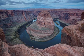
NPS / Brent&Dawn Davis HikingThe hike to the overlook is 1.5 miles (2.4 km) round-trip over a hardened path. The trail is accessible under the regulations of the Architectural Barriers Act. There are two shade structures along the length of the trail, but not at the overlook. Pets on leash are permitted on the trail. There are railings at the edge of the overlook's viewing platform, but not along the trail. Much of the rim remains exposed to the 1000-foot drop, so watch your footing and keep track of your children and pets. The desert can be a harsh and unforgiving environment, especially if you are not accustomed to it.Drink plenty of water, even when you are not thirsty, your body can lose large amounts of water without you realizing it. Be aware of balancing fluid and electrolyte levels. Minimize direct exposure to the sun. Sunburn reduces your body's ability to dissipate heat. Know the signs of heat exhaustion and heat stroke. Slow down: reduce, eliminate or reschedule strenuous activities until the coolest time of the day. Children, seniors and anyone with health problems should stay in the coolest available place. Watch your pets: ground temperatures in the sun are higher than air temperatures. Our buddies close to the ground need protection from the heat too. DO NOT leave pets in your vehicle alone for any amount of time. As with any hike, be prepared with plenty of water, sturdy footwear, sunscreen, and other basic hiking essentials. There is no water available along the trail. There is very little shade along the Horseshoe Bend Trail. Avoid hiking during the hottest part of the day. Where Am I?Horseshoe Bend has been featured as a landmark for Glen Canyon National Recreation Area, Grand Canyon National Park, the Cities of Page AZ, Kanab UT, St George UT, and the Navajo Nation. Boundary lines are very close in some places. Horseshoe Bend itself, and that part of the Colorado River, are a part of Glen Canyon National Recreation Area. About nine miles downstream is where Grand Canyon National Park begins. US Highway 89, the land north of the trail to the Horseshoe Bend overlook, and the parking area for the trailhead are in the City of Page. The land south of the parking area and the trail and overlook are on the Navajo Nation. This mixture of jurisdictions provides a unique opportunity in the management of this magnificent trail and overlook. An Entrenched MeanderBelow the rim, the Colorado River makes a wide sweep around a sandstone escarpment. On its long downward journey to the sea, the river meandered, sometimes making wide bends, but always seeking the path of least resistance. Around 5 million years ago, the Colorado Plateau uplifted and the meandering rivers that crossed the ancient landscape were trapped in their beds. Over time, the rivers cut through the uplifted layers of sandstone. Here at Horseshoe Bend, the Colorado River created a roughly 1,000 ft (305 m) deep, 270º horseshoe-shaped bend in Glen Canyon. Parking FeesHorseshoe Bend itself is in Glen Canyon National Recreation Area, but the parking lot is on city land. The City of Page requires visitors to pay for parking at the Horseshoe Bend trailhead. America the Beautiful/National Park Service passes do not apply for the parking lot. Contact the City of Page for questions about the parking at Horseshoe Bend at their website. 
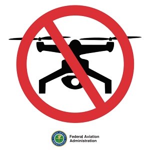
FAA graphic No Drone ZoneLaunching, landing, or operating an unmanned aircraft from or on lands and waters administered by the National Park Service within the boundaries of Glen Canyon National Recreation Area and Rainbow Bridge Monument is prohibited except as approved in writing by the superintendent. TITLE 36 CODE OF FEDERAL REGULATIONS Read more about unmanned aircraft in the national parks. Where should I go next? |
An official website of the United States government
Here's how you know
Official websites use .gov
A
.gov website belongs to an official government
organization in the United States.
Secure .gov websites use HTTPS
A
lock (
) or https:// means you've safely connected to
the .gov website. Share sensitive information only on official,
secure websites.
