|
You are viewing ARCHIVED content published online before January 20, 2025.
Please note that this content is NOT UPDATED, and links may not work. For current information,
visit https://www.nps.gov/aboutus/news/index.htm.
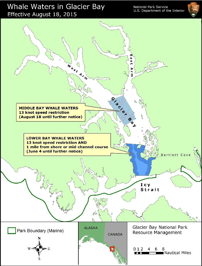
Contact: Albert Faria, Chief Ranger, 907-697-2230 Contact: Chris Gabriele, Whale Biologist, 907-697-2664 Glacier Bay National Park and Preserve Acting Superintendent Albert Faria announced today two changes to whale waters that will go into effect at 5 AM Tuesday August 18. First, a vessel speed limit of 13 knots through the water will be implemented in the middle of Glacier Bay to protect numerous humpback whales that have been feeding in this area. Second, the whale waters that have been in place around Berg Bay since July 28 will be lifted. Whale waters in lower Glacier Bay remain unchanged. As shown on the attached map, whale waters are currently designated in the following areas. Middle Glacier Bay - 13 knot speed restriction only: This area is defined by the following boundaries:
Lower Glacier Bay - 13 knot speed and course restriction: This area includes the waters between the mouth of Glacier Bay and a line drawn between the northern tip of Strawberry Island and the northern tip of Lars Island. This boundary is shown on NOAA nautical charts of Glacier Bay. The whales in the middle of Glacier Bay appear to be feeding on a deep layer of prey and are moving erratically and diving for long periods of time. Over the past week, there have been several incidents in which whales surfaced unexpectedly in close proximity to transiting vessels. Park managers note that there are shifting concentrations of humpback whales elsewhere in Glacier Bay, including Whidbey Passage, at the mouth of the West Arm and in the vicinity of Gloomy Knob, a common wildlife watching area. Boaters are advised to proceed cautiously in all areas where whales may be present because whales may surface in unexpected locations, posing a hazard to both the vessel and the whale. Vessels are prohibited from operating within ¼ nautical mile of a humpback whale in Park waters, including those Park waters outside Glacier Bay proper. Any vessel inadvertently positioned within ¼ nautical mile of a humpback whale must immediately slow the vessel to 10 knots or less. Speed and course restrictions in whale waters are intended to reduce the disruption of feeding humpback whales and to lower the risk of whale/vessel collisions, as authorized by Title 36 of the Code of Federal Regulations, Subpart N, 13.1174. Boaters are advised to verify whale waters designations prior to entering Glacier Bay by telephoning (907) 697-2627 or by contacting KWM20 Bartlett Cove on marine VHF radio. For a printer-friendly PDF version of this news release, please click here. |
Last updated: December 1, 2017