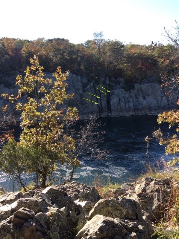
NPS - Nanette Nyce Near the head of Mather Gorge, just south of Rocky Islands is a striking series of dark, vertical lines visible on both sides of the Potomac River. Slightly offset on either side of the river, they serve to illustrate the variety of forces that created the surrounding rock formations. If you're in the C&O Canal National Historical Park, these dikes are best seen from .2 miles past the head of Billy Goat A trail. Tectonic pressures within the earth’s crust leave it full of cracks, or fractures. The cracks in the rock surrounding Great Falls may have been caused during the collision that formed the Appalachians about 480 million years ago. The lamprophyre is an igneous rock that traveled upward as molten rock into these cracks, cooled, then was subjected to intense amounts of heat and pressure. These intrusions of the lamprophyre into the cracked stone are called “dikes” and are estimated to have occured about 360 million years ago.
Erosion, heat, and pressure are major players in developing the geology of a region and continue their effects today. Consider where you live - are there streams, rivers, oceans? Then your landscape is being shaped by water erosion. New sedimentary rock is being created as sediments are eroded, moved, and layered by the water. Heat plays a role in earth's crust, especially in areas where a magma chamber is closer to the surface, such a near a volcano. Where two plates collide in subduction zones or slip past one another in fault lines, great pressure will alter the properties of the rock. Being buried deeply in the earth's crust also creates greater pressure on rock as the weight of the upper rock presses upon the lower. These forces work in cycles to constantly transform the earth. |
Last updated: September 6, 2023
