BackgroundLearn about rocks, geology, and geography at the C&O Canal before using your own observations of rocks to become a geologist.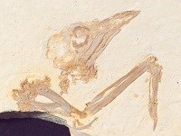
NPS Photo / Fossil Butte National Monument, Lincoln County, Wyoming Why are rocks important?Rocks contain clues about what Earth was like in the past! Scientists that study rocks are called geologists. Geologists use geoscience to study and learn about our planet and events that happened long ago by studying the rocks all around us. This research helps with natural resource management. To learn more about geoscience and other different types of geoscientists, visit our Junior Geoscientist page. 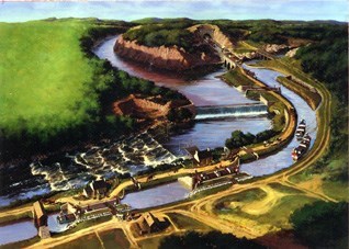
NPS Drawing Geography along the C&O Canal:From the very beginning of the Chesapeake and Ohio Canal, geography would prove to be a challenge. On July 4, 1828, United States President John Quincy Adams worked up a sweat as he attempted to “break ground” during a ceremony to start construction of the C&O Canal. Time after time his shovel hit rock just below the ground’s surface. President Adams didn’t give up though, and after several attempts he finally scooped the first shovel of dirt – the crowd watching cheered! And then, the real work began. The ominous ground-breaking ceremony foreshadowed the challenge awaiting canal workers, as they worked to build a canal for hundreds of miles in rocky terrain along the Potomac River and into the mountains. Inhabitant (In-hab-i-tant): A person or animal that lives in a particular area or place. Conglomerate (Con-glom-er-ate): Geology-Rock made from a mixture or fragments of several sources. Fragment (Frag-ment): a broken piece of something, in this case broken rock.
The C&O Canal’s Rock Collection: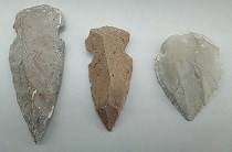
NPS Photo / Kelly Savannah Spear Points (Arrowheads)The first inhabitants of the upper Potomac River were hunters and gatherers and they would make their spears from volcanic stone called rhyolite, which can be found on certain slopes of the Blue Ridge and Catoctin Mountains. Spear points were most likely made between 7800 and 6000 BC and would often have a split or “bifurcated” base (Bedell, J., Fiedel, S., & Shellenhamer, J., 2011).1 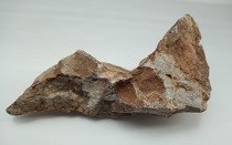
NPS Photo / Kelly Savannah Siltstone (Leesburg Member)This is a limestone conglomerate (mixture) composed of limestone and other rock fragments from previously existing rock formations cemented together by calcium carbonate (Ex. what chalk is made from). The reddish color is due to the iron content in the silt. Fragments of this rock are sub-angular in shape and vary in size. The name Balls Bluff, originated from being quarried on both sides of the Potomac River Valley near Washington, D.C. Interesting fact: It is also known as Potomac marble by builders due it’s multi-colored appearance, although it is not marble and the columns of the United States Capitol are made of this stone (USGS, 1999).6 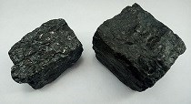
NPS Photo / Kelly Savannah CoalKnown as "the rock that burns clean," high quality coal is formed from decaying plant matter. Bituminous coal can be found near the canal’s terminus at Cumberland, Maryland. This was a valuable resource for factories, warming homes, and transportation, based on its relatively clean burning in the 19th and 20th centuries. To learn more visit Cumberland Coal. 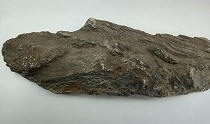
NPS Photo / Kelly Savannah LimestoneConococheague Limestone is an impure limestone containing layers of silt and dolomite (a solid form of organic materials). Unlike most limestone, it is hard and resistant to erosion. It has been used as a building stone in the Williamsport, Maryland area, and in the construction of the C&O Canal aqueduct over Conococheague Creek; to which it was named. 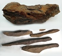
Top Image: NPS Photo / Kelly Savannah; Bottom Image: NPS Photo / Nanette Nyce. ShaleMahantango is a sedimentary rock that is predominantly made of shale and although it is solid, it is known to fracture. This type of shale commonly contains fossils of small marine invertebrates, known as brachiopods. Most brachiopods like mollusks or clams use their pedicle (fleshy arm or limb), to move up and down within mud. It has been hypothesized that these small creatures dug through the mud before it hardened resulting in the fossils that we see today. During C&O Canal excavations, the rock would break into long, slender, and uneven shards as shown in the picture to the left. This made excavations (digging) in an abandoned valley of Mill Run at Oldtown easier for construction because there are bluffs of shale along the Potomac River that prevented construction of a canal and towpath (Southworth et al., 2008).4 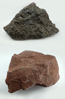
NPS Photo / Kelly Savannah Red SandstoneThis fine-coarse grained sandstone contains tiny flakes of mica and may locally contain small pebbles. Named for exposures near Poolesville, Maryland this sandstone is called Manassas Sandstone by geologists and is also referred to as, Seneca Red Sandstone for the iron oxide that gives the stone’s its rust red color and that it has also been found near the mouth of Seneca Creek, in Seneca, Montgomery County, Maryland. (Lee, K.Y., and Froelich, A.J., 1989). 2 The colors of the stone range from a gray, deep purplish brown to red as it is weathered. This stone was a favorite building stone and was transported to Washington for several building sites along the canal such as lock keepers’ houses, the Seneca Creek Aqueduct and even the Smithsonian Castle on the National Mall in Washington, D.C. 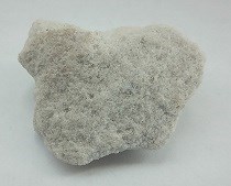
NPS Photo / Kelly Savannah White SandstoneThis pure white quartz sandstone is soft and can easily crumble when exposed to weathering. This is because the cement that holds the quartz grains together is predominately calcium carbonate (Ex. what chalk is made from). Oriskany Sandstone was not widely used in the construction of the canal based on its tendency for weathering. However, its natural gas bearing formation made it widely popular as a source of silica for manufacturing the finest of crystal glass products. 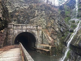
NPS Photo / Ranger Hollie Lynch Construction versus NatureConstruction of the canal was a tough and hard task for the canal workers. The rough terrain and mountain took a lot of time, money, and energy. In fact, the original plan was to build the canal all the way to the Ohio River in Pennsylvania so that boats could travel to the West. However, by the time, the canal company reached Cumberland, Maryland, and the experience of the Paw Paw tunnel (Digging a 3,118-foot tunnel through the hard, loose shale), the decision to continue through the Allegheny Mountains to Pittsburgh, Ohio, was no longer an option. Even though the company never made it to Ohio, they kept the name, which is why the canal was named C for the Chesapeake Bay and O for the Ohio River! (See image of proposed map route below). Visit Canal Construction for more information. 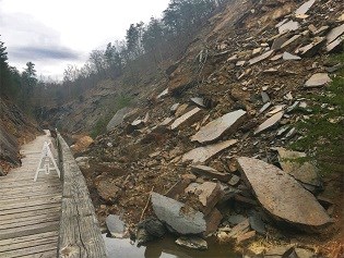
NPS Photo / Ranger Hollie Lynch Rockfalls at the Paw Paw TunnelIn 2016, there was a major rockslide that occurred at the north portal (downstream entrance to the tunnel) of the Paw Paw Tunnel; Refer to the image to the right. Rockslides (rockfalls) are natural geological processes that take place when rock breaks and moves freely from a cliff face downward at fast speeds. There are many causes for rockfalls such as, earthquakes, water, and vegetation (plant) growth. Earthquakes occur when the earth’s plates shift and collide, causing the earth to shake and rocks to tumble down (rockslide). This is rare to our area but can happen. If water enters through cracks in rock formations then freezes and thaws; process called "frost wedging" or "freeze-thaw," this can cause the rock to loosen and fall away from the cliff. Additionally, plant growth such as firs, pines and other evergreen trees grow in rocks; when their roots expand, they can break through the rock causing rockfalls to occur (Rockfall, 2021).3 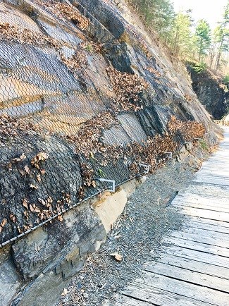
NPS Photo / Joe Reed, Park Engineer
Egg Carton Rock Collection Activity!Be a geologist for a day, get outdoors, and explore! Use your skills of observation to learn about the geology around you.*Scientific skills: Observation, Data collection, and Classification 
NPS Photo / Kelly Savannah Materials:
Optional Items:
Step 1: Decorate your egg cartonOnce you have gathered all of your art supplies, have fun decorating your egg carton. Maybe use the stickers to spell out your name on the top of the egg carton. See example below: 
NPS Photo / Kelly Savannah 
NPS Image / Kelly Savannah Upcycle challenge: Find a fun way to reuse materials while you decorate!
Step 2: Time to Rock!After you finish decorating your egg carton, take a walk with your family or friends and collect some rocks that will fit inside of your egg carton (see example below). Please remember when visiting National Parks like the C&O Canal to “Take nothing but photos and leave nothing but footprints!” Learn more about Leave No Trace Principles. 
NPS Photo / Kelly Savannah, Rock ID Chart inside image was created by Raisa Barrera. Step 3: Sort and ClassifyOnce you have gathered a few rocks, see if you can sort and classify the rocks. Make observations by using your senses. Feel the texture of each rock. Is it smooth or rough? Is it hard or brittle? What color is the rock? Is it one solid color or many colors? Can you see layers or small pebbles in the rock? A magnifying glass will help you examine your rocks closely. How to sort & classify your rocks:

Extension Activities:Add a math component!Count the number of rocks that fall under the different sorting categories. For example, if you choose to sort your rocks by color, count the number of white rocks, green rocks, pinkish red rocks, etc. or if you choose to sort your rocks by type, count the number of rocks that are igneous, metamorphic or sedimentary. Classify and Record your answers on a notepad to graph the results later. Older Ages:Using the Printable Rock ID Chart, identify the rocks you collected and write the results in a notepad. Then count the number of rocks that fall under each type of rock category to graph later. 1 Bedell, J., Fiedel, S., & Shellenhamer, J. (2011). A PATH THROUGH THE MOUNTAINS: THE ARCHEOLOGY AND HISTORY OF THE CHESAPEAKE & OHIO CANAL NATIONAL HISTORICAL PARK. The Louis Berger Group, Inc. Handbook for The National Park Service National Capital Region, pg. 9.
|
Last updated: December 1, 2025

