Alaska is the most geologically active part of North America. Much of the awe-inspiring landscapes of Alaska's parks are created by geologic processes. But sometimes, these processes can be hazardous. This issue explores the state of the science to understand geohazards in Alaska national parks. Alaska Park Science 18(1): 2019.
-
Article 1: Download Alaska Park Science, Volume 18, Issue 1: 2019
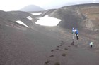
Alaska is the most geologically active part of North America. Much of the awe-inspiring landscapes of Alaska's parks are created by geologic processes. But sometimes, these processes can be hazardous. Read about earthquakes, tsunamis, landslides, glacier collapses, glacier outburst floods, volcanoes and volcanic eruptions, river ice, erosion, and more. This issue explores the state of the science to understand geohazards in Alaska national parks. Alaska Park Science 18/1:2019 Read more
-
Article 2: Geohazards in Alaska’s National Parks
Geohazards are geologic processes that may pose a risk to people and our infrastructure. They include landslides, tsunamis, ice-dam floods, glacier calving, earthquakes, and volcanic eruptions—all of which occur in Alaska parks. In this issue of Alaska Park Science, we explore these geohazards: how they happen, where they could happen, and how we might mitigate their impacts. Alaska Park Science 18(1), 2019. Read more
-
Wrangell - St Elias National Park & Preserve
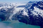
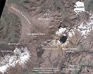
Article 3: The 2015 Taan Fiord Landslide and Tsunami
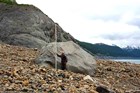
On October 17, 2015, 180 million tons of rock slid into Taan Fiord generating a tsunami that stripped forest from 8 square miles and reached as high as 633 feet above the fjord, the fourth-highest tsunami ever recorded. Luckily, no one was near enough to be harmed. Cracking and shifting of the mountain for decades before the landslide could have provided warning, and similar conditions exist elsewhere in Alaska parks. Alaska Park Science 18(1):2019. Read more
-
Wrangell - St Elias National Park & Preserve
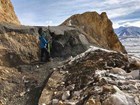
Article 4: Catastrophic Glacier Collapse and Debris Flow at Flat Creek
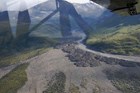
Debris flows are common events in mountainous regions. At Flat Creek, we expected to find a very large debris flow or landslide. Instead, we found that an entire glacier had spontaneously detached off the mountainside, sending millions of cubic yards of ice and debris shooting down the valley in two catastrophic mass flows. Almost six years later, we are only just starting to piece together what actually happened. Alaska Park Science 18(1):2019. Read more
-
Glacier Bay National Park & Preserve
Article 5: An Initial Assessment of Areas Where Landslides Could Enter the West Arm of Glacier Bay, Alaska and Implications for Tsunami Hazards
Tsunamis generated by landslides in Glacier Bay are uncommon, but have potential to be extraordinarily destructive when they occur. This article identifies areas that are susceptible to landslides that could generate tsunamis and discusses approaches to characterize hazard and risk from these events. Alaska Park Science 18(1):2019. Read more
-
Kenai Fjords National Park
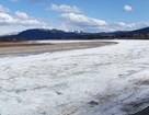
Article 6: Risk and Recreation in a Glacial Environment: Understanding Glacial Lake Outburst Floods at Bear Glacier in Kenai Fjords National Park
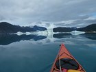
Glaciers and the landscapes they create are beautiful, dynamic places to experience as a distant observer, skilled adventurer, or inquisitive scientist. They can also be dangerous; ice falls, calvings, collapses, and outburst floods can and do occur without warning. We study and monitor Bear Glacier to better understand hydrological processes leading to glacial lake outburst floods so we can mitigate their impacts. Alaska Park Science 18(1), 2019. Read more
-
Denali National Park & Preserve
Article 7: Geohazard Risk Reduction along the Denali National Park Road
The dramatic landscapes of Denali National Park are largely a result of geologic forces. The park road, the main access to the park for visitors and staff, is especially susceptible to landslides that have blocked access for days. We monitor geohazards in the park and actively reduce risk. Alaska Park Science 18(1), 2019. Read more
-
Article 8: Volcanic Hazards in Alaska’s National Parks
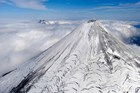
There are over 100 volcanoes in Alaska, 54 of which are considered historically active, and 14 are found in Alaska national parks, preserves, and monuments. The Alaska Volcano Observatory monitors and conducts research on volcanoes in Alaska in order to better understand volcanic processes and determine the likelihood of future volcanic hazards, with a primary goal of informing the public about volcanic hazards and impending volcanic activity. Alaska Park Science 18(1), 2019. Read more
-
Katmai National Park & Preserve
Article 9: Volcanic Ash Resuspension from the Katmai Region
Volcanic ash is not only a hazard during an eruptive event; in strong winds, previously deposited volcanic ash can be reincorporated into dust clouds. Resuspension and transport of fine-grained volcanic ash from Katmai National Park and Preserve has been observed and documented many times over the past several decades and has likely been occurring since the 1912 Novarupta-Katmai eruption, the largest 20th century eruption in the world. Alaska Park Science 18(1):2019. Read more
-
Yukon - Charley Rivers National Preserve
Article 10: Spring Breakup on the Yukon: What Happens When the Ice Stops
Spring breakup can create flooding and ice-scouring hazards for communities along major rivers in Alaska. This article gives examples of recent flood events along the Yukon River and describes the conditions that created them. Alaska Park Science 18(1):2019. Read more
-
Article 11: Coastal Dynamics in Bering Land Bridge National Preserve and Cape Krusenstern National Monument
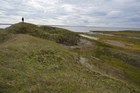
Arctic coastlines are changing as a result of warming temperatures and decreasing sea ice extent and duration. An understanding of these changes can contribute to the effective management of coastal habitats and ecosystems, oil-spill response, marine debris collection, and the preservation of cultural artifacts. Alaska Park Science 18(1):2019. Read more
-
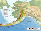
Article 12: Addressing Earthquake and Tsunami Hazards in Alaska Parks
The forces that produce hazards such as earthquakes and tsunamis are as much a part of the parks--and the parks' beauty--as wildlife and glaciers. Engaging visitors in learning about and preparing for these hazards serves the dual functions of increasing park safety while also enriching the visitor experience. Alaska Park Science 18(1):2019. Read more