Last updated: January 31, 2025
Article
Natural High Points of States in Parks
We all strive to reach new heights whether taking on the physical challenge to climb to the top or armchair-exploring from the comfort of our own home through virtual experiences. Discover the highest natural points in each state that are located within the National Park System, many of which can be visited by hikers, climbers, mountaineers, and drivers who are often rewarded by breathtaking views. Find photos, virtual tours, webcams, fun facts, and more on park websites and social media channels.
If venturing out to climb every mountain, remember to plan your trip and recreate responsibly for a safe, rewarding adventure. Share your mountain experiences and inspirations on social media using #FindYourPark or #EncuentraTuParque.

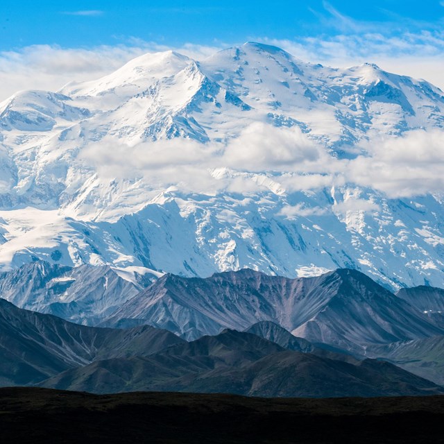
Courtesy of Luke Marson
Alaska: Mount McKinley in Denali National Park & Preserve
The peak of Mount McKinley is not only the highest point in Alaska, but also on the continent of North America. At 20,310 feet (6190 meters), Mount McKinley is the crowning peak of the Alaska Range, which stretches 600 miles in a long arc on the Alaska-Canada border. The mountain is so tall that it can be seen towering over the Alaska landscape by astronauts in space! Learn more about the history of the mountain’s names, which often referenced its incredible size.

NPS Photo
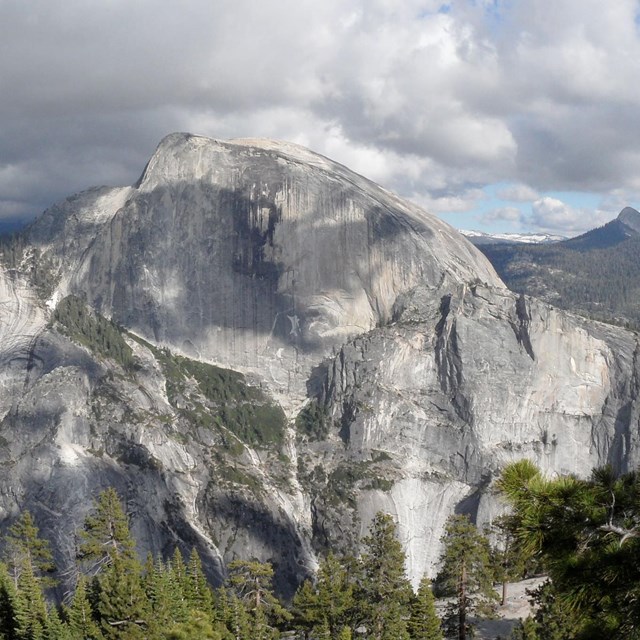
California: Mt. Whitney in Sequoia & Kings Canyon National Parks
Known as the tallest mountain in the “lower 48” states, Mt. Whitney is located on the far eastern boundary of Sequoia National Park and in neighboring Inyo National Forest. It happens to be within 85 miles of the lowest place in North America, the Badwater Basin in Death Valley National Park. Requiring a permit before setting out, it is one of the most popular climbed mountain peaks in the Sierra Nevada with its summit at a height of 14,494 feet (4418 meters).

NPS Photo
District of Columbia: Fort Reno in Rock Creek Park
The highest natural point in the District of Columbia was once part of an elaborate network of forts defending the nation’s capital during the Civil War. In 1864, Fort Reno participated in repelling an assault on Washington by the Confederate Army during the Battle of Fort Stevens. At 409 feet (125 meters) high, it is still lower than the top of the Washington Monument standing at 555 feet 5-1/8 inches (169 meters) tall.

Courtesy of Todd M. Edgar
Maine: Mount Katahdin on the Appalachian National Scenic Trail
Located in Baxter State Park, Mount Katahdin is the north terminus of the Appalachian National Scenic Trail and the ultimate goal of northbound thru-hikers on their 2,190-mile journey. It is also the south terminus of the International Appalachian Trail extending into Canada. A round-trip day hike can take eight to ten hours for those hoping to summit its tallest peak at 5,269 feet (1,606 meters). The mountain is a designated national natural landmark.

Courtesy of the Appalachian Trail Conservancy
Massachusetts: Mount Greylock on the Appalachian National Scenic Trail
Located within Mount Greylock State Reservation, the mountain has the highest natural peak in Massachusetts at 3,491 feet (1,064 meters). Many trails, including the Appalachian National Scenic Trail, traverse the mountain showcasing the scenery of the Taconic and Berkshire Mountains. The Massachusetts Veterans War Memorial Tower rests on the mountain's summit.

Courtesy of Spencer Black
Tennessee: Clingmans Dome in Great Smoky Mountains National Park and on the Appalachian National Scenic Trail
At 6,643 feet (2,025 meters), Clingmans Dome is the highest point in the state and the third highest mountain east of the Mississippi River. Those hiking the Appalachian National Scenic Trail on Clingmans Dome reach the highest point on the trail on the stretch between Georgia and Maine. Most visitors drive to the top of the mountain if weather and conditions permit (it can be windy...very windy). On clear days, you can see more than 100 miles of a 360-degree breathtaking view from the mountain’s observation tower.

NPS Photo
Texas: Guadalupe Peak in Guadalupe Mountains National Park
Those who reach Guadalupe Peak, also known as the “Top of Texas,” can enjoy a beautiful view of the Guadalupe Mountains and Chihuahuan Desert from 8,751 feet (2,667 meters) high. A strenuous six to eight hour day hike with a 3,000 foot elevation gain to summit Guadalupe Peak is among the most popular trails in the park. A pyramid-shaped marker commemorating mail delivery by overland stage and air travel marks the summit. Despite its desert appearance today, the mountain is part of a fossilized Permian period reef that was in a great inland sea 251 to 299 million years ago!

NPS Photo
Washington: Mount Rainier in Mount Rainier National Park
An icon on the Washington horizon, Mount Rainier stands 14,410 feet (4,392 meters) above sea level making it hard to miss. An active volcano, it is the highest mountain in the Cascade Range and the Cascade Volcanic Arc. Reaching the peak is an exciting challenge for prepared mountaineers, who gain more than 9,000 feet in vertical elevation during the ascent.