Article

Southeast Coast Network News October 2022

man and woman holding a tall measuring stick
NGPN Aquatic Ecologist Anine Rosse and SECN Physical Scientist Stephen Cooper take a stream measurement at Theodore Roosevelt National Park in North Dakota.

NPS photo / Eric Starkey

Helping Out in the Midwest Region

Aquatic Ecologist Eric Starkey and Physical Scientist Stephen Cooper recently provided wadeable stream channel monitoring field assistance at Knife River Indian Villages National Historic Site and Theodore Roosevelt National Park in North Dakota. Their involvement was a natural fit because the Southeast Coast Network's protocol for stream channel habitat monitoring has been adapted for implementation by the Northern Great Plains Inventory and Monitoring Network (NGPN). Helping in North Dakota allowed the SECN aquatic team to evaluate new technology (i.e., scanning Total Station) and hone skills related to the sometimes tricky identification of geomorphic features. The Southeast Coast Network hopes to invite NGPN Aquatic Ecologist Anine Rosse to join stream surveys planned at Kennesaw Mountain National Battlefield Park, Horseshoe Bend National Military Park and Ocmulgee Mounds National Historical Park in early summer of 2023. Cross-network collaboration allows the NPS Inventory and Monitoring Division (IMD) to leverage the expertise of staff across the country and provides on the ground educational opportunities for staff from both networks.

man in a river with tripod in the distance
SECN Aquatic Ecologist Eric Starkey takes detailed transect measurements at Knife River Indian Villages National Historic Site in North Dakota.

NPS photo / Stephen Cooper

FY23 Steering Committee Meeting in November will be Virtual

The Southeast Coast Network's FY2023 Steering Committee is November 16, from 8 a.m. to 4 p.m. This year’s meeting will again be virtual. The decision to go virtual was made after discussions with the SECN Board of Directors and with the safety of SECN and park staff in mind. Hopefully we will get back to gathering in person in the near future. The meeting's format will follow previous years with presentations from each SECN program lead highlighting our FY 23 workplan and accomplishments from FY22. You will have a chance to ask us questions and voice concerns about our program. You will also get a chance to review the workplan and annual report documents prior to the meeting. The Board meeting will follow soon after the Steering Committee meeting and more details will follow in the coming weeks.

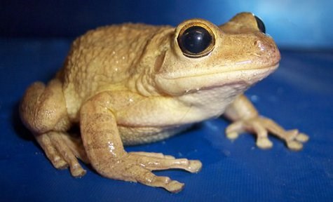
frog
A Cuban treefrog is one of several species detected during monitoring in 2021 at Cumberland Island National Seashore. It is non-native and was not previously detected at the park.

Photo by Denise Gregoire, USGS

Finding a Frog

In September, the Southeast Coast Network augmented its regularly scheduled monitoring and deployed six automated recording devices (ARDs) on the south end of Cumberland Island National Seashore. The ARDs will help the network perform follow-up work on a Cuban treefrog (Osteopilus septentrionalis) detection made in previous recordings. Cuban treefrogs are an invasive non-native species that can outcompete many of the native frogs and the finding marks the first documentation of this species on the island. The ARDs will record through the end of the year (Cuban treefrogs breed through October), and monitoring for this species will continue in the spring.

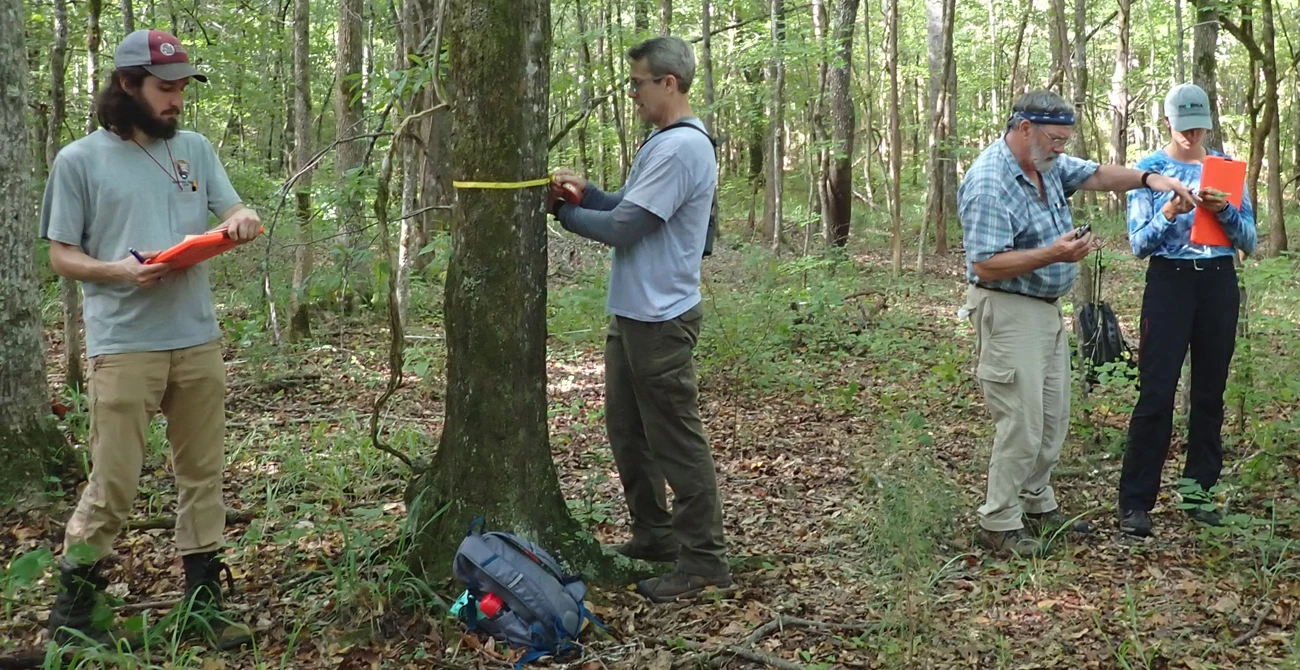
Man with clipboard, man measuring a tree, and a man and woman looking at plant, all in the woods
Vegetation monitoring at Horseshoe Bend National Military Park. From left, Richard Smith, Appalachian Highlands Network Intern; Bill Moore, Cumberland Piedmont Network Ecologist; Tom Govus, private contractor; and Mallorie Davis, Cumberland Island National Seashore Intern (photo was not staged!).

NPS photo / M. Forbes Boyle

FY2022 Field Work Update

The FY2022 fieldwork season is coming to a close for the Southeast Coast Network. Data collected for each SECN monitoring program is being processed with reports and data packages on the horizon.

Coastal Wetlands

New Surface Elevation Table (SET) sites will be installed at Cape Lookout National Seashore and Cape Hatteras National Seashore this month. A revised monitoring protocol is currently waiting on regional approval with publication expected later this year.

Shorelines

Data collected in the spring surveys at Canaveral National Seashore, Cumberland Island National Seashore, Timucuan Ecological and Historic Preserve, Fort Matanzas National Monument, Cape Lookout National Seashore and Cape Hatteras National Seashore have been processed with reports coming out in the near future. Fall monitoring is currently planned at Cape Hatteras National Seashore, Cape Lookout National Seashore and Fort Matanzas National Monument with other mapping activities anticipated due to impacts of Hurricane Ian. These data are made available to parks in a user-friendly dashboard recently created by SECN staff.

Vegetation Communities

The 2022 fieldwork season wrapped up with monitoring at Horseshoe Bend National Military Park. Additional parks completed this season included Cape Lookout National Seashore, Moores Creek National Battlefield and Canaveral National Seashore. Data continues to be processed from last summer's field work at Congaree National Park, Ocmulgee Mounds National Historical Park, Chattahoochee River National Recreation Area and Kennesaw Mountain National Battlefield Park.

Wadeable Streams

Processing continues for data collected from wadeable stream monitoring surveys conducted in May at Congaree National Park. A summary report from last year's data collection at Chattahoochee River National Recreation Area will be out later this year.

Water Quality

Park-wide water-quality assessments were conducted at Cumberland Island National Seashore and Fort Matanzas National Monument in July. A water-quality data collection trip was completed in August for Congaree National Park, Fort Pulaski National Monument, Cumberland Island National Seashore, Canaveral National Seashore, Fort Matanzas National Monument, and Timucuan Ecological and Historic Preserve. Monthly visits will continue throughout FY2023, including later this month. Fixed-station time-series data collection continues with assistance from park staff and partners at Cape Hatteras National Seashore, and Cape Lookout National Seashore.

Landbird and Anuran Communities

A handful of ARDs were collected in September from Congaree National Park, officially bringing the 2022 anuran and landbird field season to a close. Parks where monitoring was conducted included Canaveral National Seashore, Fort Frederica National Monument, Moores Creek National Battlefield, Congaree National Park, and Ocmulgee Mounds National Historical Park. ARD deployments for the 2023 field season begin in December. Parks include: Cape Hatteras National Seashore, Chattahoochee River National Recreation Area, Fort Matanzas National Monument, Fort Pulaski National Monument, and Timucuan Ecological and Historic Preserve. Analysis of 2021 landbird and vocal anuran monitoring data at Cape Lookout National Seashore, Cumberland Island National Seashore, Fort Sumter and Fort Moultrie National Historical Park, Horseshoe Bend National Military Park, and Kennesaw Mountain National Battlefield Park is moving along with all reports expected to be completed near the end of this calendar year. In addition to completing the scheduled monitoring for FY 2022, recordings collected in FY 2015, 2016 and 2017 (anurans) are being processed and data sets from these monitoring events will be published in the near future.

Recent Publications

The Southeast Coast Network recently published the following reports:

photo of a stream
A new ArcGIS Story Map highlighting the Southeast Coast Network's Wadeable Stream Habitat Monitoring Program was published recently. Streaming Live is available online. Click on the image above to access the map.
man wearing a life vest holding a weather gauge
Former SECN Hydrological Technician Daniel McCay.

NPS photo / Mark Hynds

Belated Goodbye

Former SECN Hydrological Technician Daniel McCay started as a Life Scientist with the Environmental Protection Agency in Athens, Georgia last month. Daniel had worked with the Southeast Coast Network since February 2019 where his primary role was the collection of discrete and continuous data for the water-quality protocol. Daniel’s monthly “sonde runs” to Georgia, Florida and South Carolina made him a frequent face in many parks. In addition to Daniel’s work on water-quality data collection, he assisted with shallow ground water monitoring at Cumberland Island National Seashore, helped complete numerous wadeable stream habitat surveys at Chattahoochee River National Recreation Area, Congaree National Park, Kennesaw Mountain National Battlefield Park, Horseshoe Bend National Military Park and Ocmulgee Mounds National Historical Park. Daniel was also the primary author on several water-quality standard operating procedures and assisted with processing continuous data for numerous sites. His hard work, attention to detail and dedication have helped with many important transitions and upgrades for the SECN water-quality monitoring program. Thanks, Daniel, for your dedication and willingness to lend a helping hand on any project! Best wishes on your new adventure!

Last updated: May 18, 2023