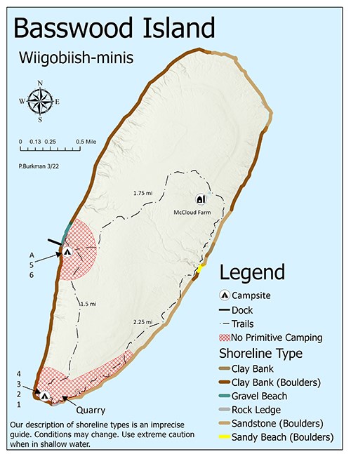
Basswood Island (Wiigobiish-minis) Hiking TrailsA 5.5 mile loop trail begins and ends at the trail intersection near a clearing up the hill from the dock. The short trail off to the right leads to campsites A, 5 and 6. The main trail proceeds northeast across a ravine, then 1.75 miles to the Historic McCloud Brigham farm site. From there the trail follows an old logging road to the east side of the island, then swings south for 2.25 miles to some excellent overlooks of the main quarry area: several large blocks of cut brownstone lie in the quarry opening and rusted parts of old equipment can still be found. From the quarry the loop trail turns north for 1.5 miles through the forest to the dock clearing. Campsite 1-4 are located southwest of the quarry area. 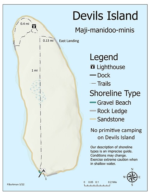
Devils Island (Maji-manidoo-minis) Hiking TrailsEast Landing Trail: 0.13 milesThis short path connects the light station to a natural rock boat landing on the northeast side of the island. The landing is a large, fairly flat expanse of sandstone. West Landing Trail: 0.4 milesThis path winds from the light station grounds to a natural rock boat landing along the cliffs on the northwest side of Devils Island. Boathouse Trail: 1.0 milesThis is the longest trail on the island that leads directly south from the light station to the boathouse and small boat harbor at the south end of the island. It follows the remnants of a road that was used by the Coast Guard to move people and supplies from one end of the island to the other. 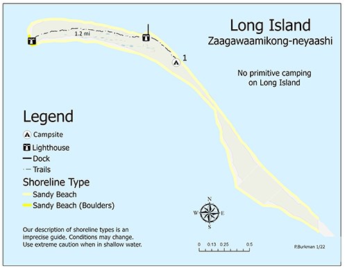
Long Island (Zaagawaamikong-neyaashi) Hiking TrailsBoard Walk Trail: 1.2 milesThis boardwalk trail connects the Chequamegon Point Light with the LaPointe Light station. 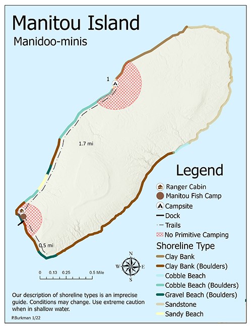
Manitou Island (Manidoo-minis) Hiking TrailsCampsite Hiking Trail: 1.7 milesThis trail starts near the fish camp on the southwestern shore of Manitou. Take the path to the vault toilet and continue up through the woods to the trail junction, veer left. Trail ends at the campsite on North west side of the island. P-flat Trail: 0.5 milesThis trail begins behind the vault toilet at the historic fish camp, take the trail to the right. Trail ends atop a low bluff at the southeast point of the island. 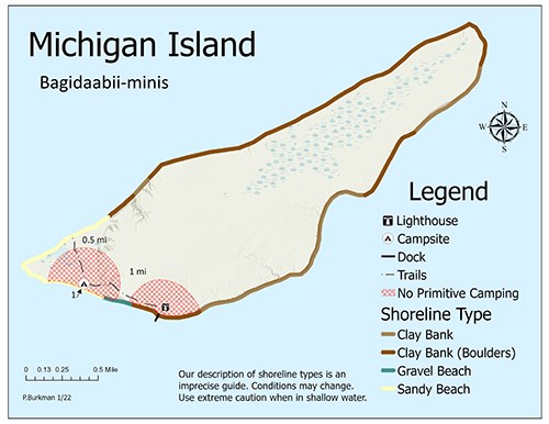
Michigan Island (Bagidaabii-minis) Hiking TrailsSandspit/campsite Trail: 1.0 milesThis trail starts behind the light station at the vault toilet and goes to the sandspit and campsite. Lagoon Trail: 0.5 milesFrom the trail intersection near the campsite the lagoon trail crosses to the northwest side of the sandspit. The trail appears to end after 0.25 miles at the edge of the bog surrounding the lagoon. The trail picks up again at the break in the trees across the bog. After passing the lagoon, the trail enters a small grove of hemlock and ends at a wave-cut slope overlooking the channel between Michigan and Stockton. 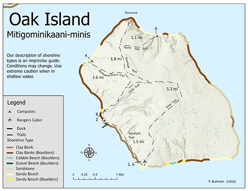
Oak Island (Mitigominikaani-minis) Hiking TrailsLoop Trail: 5.2 milesA horseshoe shaped trail that begins at the dock. Loops north through the center of the island then turns south to the sandspit. You get to walk over the highest point in the lakeshore, along ancient beach lines, and past the old “sugar bush.” Northwest Beach Trail: 1.6 milesThis trail leaves the loop trail 1.2 miles north of the dock and leads to a secluded beach and campsite #4 (2.8 miles from the dock). Overlook Trail: 1.8 milesBeginning 1.7 miles from the dock, this trail departs the loop trail near the highest point on the island. It leads to an overlook 200ft about the lake with a view of 10 islands and the “hole in the wall” sea arch. The overlook is 3.5 miles from the dock. North Bay Trail: 1.1 milesThis trail meanders down a ravine to campsite #6, which is 4.0 miles from the dock. Sandspit Trail: 1.5 milesThis trail travels along the shoreline to the beach at the sandspit. Campsites 1 and A and an outhouse are located here. To protect the sandspits fragile plant community, walk only on established trails, boardwalks, or the beach. 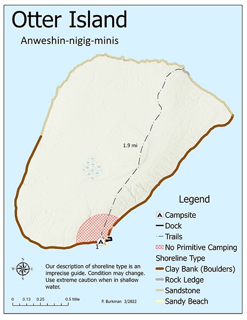
Otter Island (Anweshin-nigig-minis) Hiking TrailsOtter Trail: 1.9 milesThis trail traverses the island from south to north. The trail starts just north of the campsite and dock area. 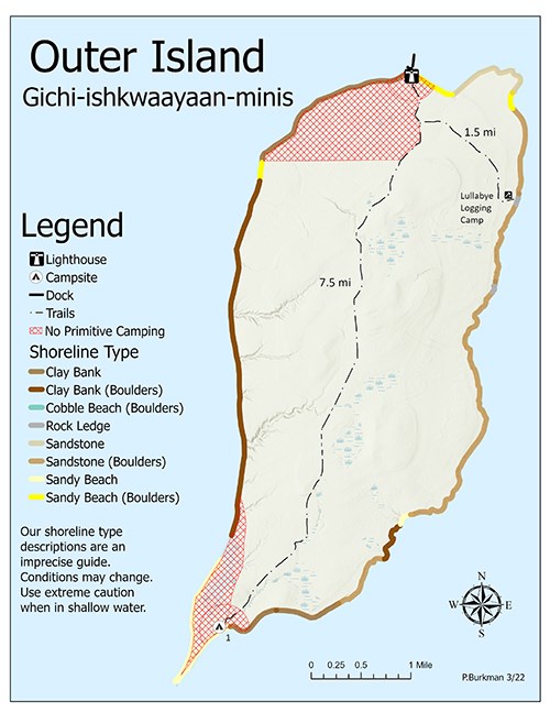
Outer Island (Gichi-ishkwaayaan-minis) Hiking TrailsSandspit Trail: 7.5 milesThis trail connects the campsite on the sandspit on the south end of the island with the light station on the north end. Lullabye Trail: 1.5 milesThe Lullabye logging camp lies 1.5 miles to the southeast from the junction with the sandspit trail. The trail ends at the sandstone ledges that make up the island’s eastern shoreline. 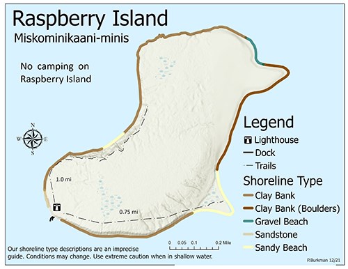
Raspberry Island (Miskominikaani-minis) Hiking TrailsWest Bay Trail: 1.0 milesThis trail was probably established in 1921, when the Raspberry Island Light Keepers began maintaining the automated light on Sand Island. The trail allowed the keepers to hike to a point where they could see the Sand Island Light. The trail begins at the west edge of the light station grounds. Sandspit Trail: 0.75 milesThis trail connects the light station with the beach on the southeast shore of the island. It was built in the early years of the light to link the station with a boathouse that once was at the sandspit. Much of the trail passes through old growth forest where sugar maple, yellow birch, and balsam fir are the dominant tree species. Dense stands of Canada yew cover much of the forest understory. 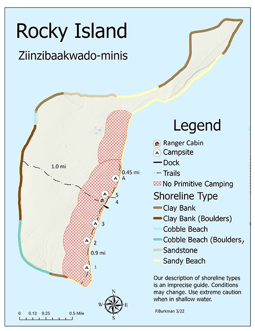
Rocky Island (Ziinzibaakwado-minis) Hiking TrailsWest Trail: 1.0 milesThis wooded trail spans the width of the island. From the dock go up the stairs and follow the boardwalk past the vault toilets to the sign that marks the beginning of the trail. South Trail: 0.9 milesThis trail parallels the shoreline on the eastern side of the island. From the bulletin board near the public dock, the trail heads south (left) through the open picnic area. North Trail: 0.45 milesFrom the bulletin board near the public dock, the trail starts to the north (right) and goes past campsites 4, 5, and A. 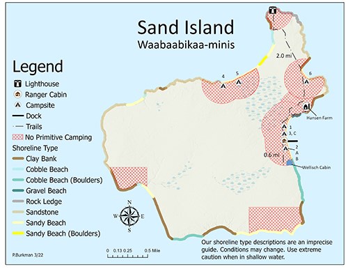
Sand Island (Waabaabikaa-minis) Hiking TrailsLighthouse Trail: 2.0 milesThis flat trail goes from East Bay dock north to the lighthouse. This trail is in the process of becoming an accessible boardwalk trail. Use caution – boards can be slippery when wet. Wellisch Cabin Trail: 0.6 milesThis trail follows the old roadbed south from the East Bay dock and goes past campsites 2, A and B. Important Note:There is no maintained trail leading to campsites 4 and 5 at Lighthouse Bay. With lower water levels, it may be possible to follow the beach. 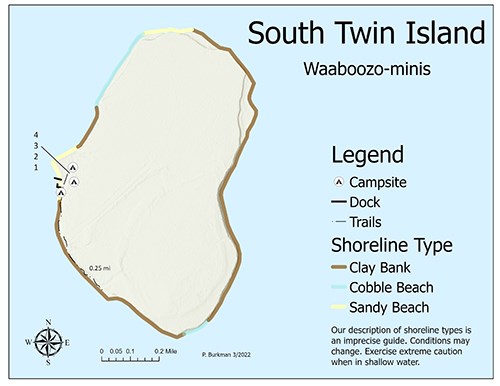
South Twin Island (Waaboozo-minis)A 0.25 mile trail links the dock area with an abandoned airstrip. 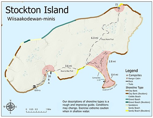
Stockton Island (Wiisaakodewan-minis) Hiking TrailsJulian Bay Trail: 0.4 milesThis trail goes from the tri-plex/ranger station on Stockton Island at Presque Isle straight across to Julian Bay beach. Anderson Point Trail: 1.4 milesThis trail winds through the forest around the rocky shoreline between Julian Bay beach and Presque Isle dock. Tombolo Trail: 2.8 milesLeaving the Quarry Bay trail 0.6 miles from the Presque Isle dock, this trail travels through the forest and bog, then onto the Julian Bay beach. Follow the beach south to the Julian Bay trail. A lagoon outlet along the beach may require hikers to wade across. Quarry Bay Trail: 3.6 milesThis trail goes from the Presque Isle dock, through the campground, past the Trout Point trailhead, en route to Quarry Bay. The path through the meadow north of Presque Isle Bay may be difficult to follow. Quarry Trail: 1.5 milesThis trail leads from Quarry Bay west along the shore to an abandoned quarry that was operated by the Ashland Brownstone Company from 1889-1897. Trout Point Trail: 6.3 miles (from Presque Isle > Trout Point)Trailhead is located on the Quarry Bay trail 1.6 miles from Presque Isle, the path winds through Stockton’s interior forest en route to the old logging camp clearing at Trout Point. The trail is unmaintained and route finding may be difficult. |
Last updated: June 8, 2022
