
Grand Canyon National Park Bulletins and Trail Brochures may be downloaded from this page.
Viewing and Printing PDF filesThe bulletins and brochures on this page are saved in the Adobe PDF format. If you are using a web browser to view and print ouor brochures, you may experience issues where the PDF does not function correctly. BulletinsCampground Information and Maps
Trail InformationIntroduction to Backcountry Hiking - (680 kb PDF File, Jan. 2016) Day Hike - Rim Trail (PDF File) Day Hike - Bright Angel Trail (PDF File) Day Hike - South Kaibab Trail (PDF File) Day Hike - Hermit Trail (PDF File) More detailed trail descriptions can be found on the Day Hiking and Trails and Use Areas web pages. 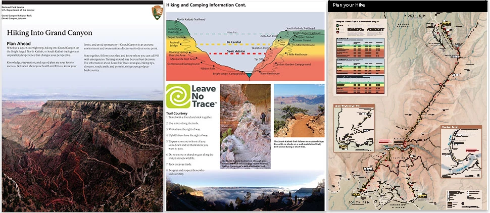

Discovering Life at Grand Canyon Grand Canyon's extreme elevation changes and dramatic topography produce a range of climates, creating homes for a surprisingly rich diversity of living things. These organisms' interactions with and adaptations to this rugged environment define Grand Canyon's ecology. South Rim Trail Brochures
(279kb PDF File - October 2015) Nowhere on this planet are the scope of geologic time and the power of geologic processes as superbly and beautifully exposed as in these canyon walls. 
Plants Living on the Edge 
Bright Angel Trail Plant Identification Guide 
Civilian Conservation Corps Walking Tour Desert View Trail Brochures
Desert View - with map (4.4 MB PDF Feb 2015) Inner Canyon Trail Brochures
Phantom Ranch Walking Tour North Rim Trail Brochures
The latest updates are posted here: 
Nine hundred years ago, people were living on the North Rim at Walhalla Glades. The site was a summer home for families for over 100 years. Walhalla Plateau is "peninsula" surrounded on three sides by the Grand Canyon. The elevation in this area is a bit lower than most of the North Rim of Grand Canyon, and updrafts of warm air from the inner canyon allow the winter snows to melt early, making Walhalla a favorable place for ancestral people to farm. |
Last updated: April 22, 2026