Gramercy Park, viewed from the deck of a residential apartment
NYPL
In the early 1830s, before the Roosevelt family moved to No. 28 East 20th Street, Samuel Ruggles proposed the development of Gramercy park as an elegant neighborhood and tranquil change of pace from city life. Ruggles was a New York politician and visionary urban planner who owned large tracts of land in Manhattan. He recognized the value of centering residences around inviting open spaces within Manhattan's strict city grid.
The Commissioners' Plan of 1811 laid out New York City's iconic grid to plan for the city's northward development. City grids were not revolutionary. Urban planning went back a few thousand years, and Philadelphia had numbered streets in a grid pattern one hundred years before New York. Nevertheless, Manhattan's grid was forward-thinking and took decades to accomplish. Before it was called New York, New Amsterdam had been settled by the Dutch in 1624. The Dutch valued the area's natural harbor as a port for trade. Streets were haphazardly laid out in today's downtown Manhattan as the city grew. Prior to 1811, the land of upper Manhattan was largely undeveloped and parceled into irregularly shaped, privately owned properties. To make way for new streets and avenues, city planners redrew property lines and demolished or relocated many buildings. Manhattan's rich natural landscape provided another obstacle. Manhattan was called Mannahatta or "island of many hills" by the Lenape Native Americans who had inhabited the island before the Dutch. It had streams, swamps, ponds, and lots of hills. City planners disregarded the natural terrain and imposed the grid on top of it. Thus they had to even elevations, cut down trees, fill in swamps, and pave new streets.
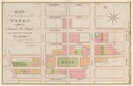
Gramercy, called Crommashie or "little crooked swamp" by the Dutch, was just one of the natural features of the island that adapted for the grid. Samuel Ruggles bought the large property between 19th Street to the south, 24th Street to the north, Broadway (then called Bloomingdale Road) to the west, and Second Avenue to the east. Ruggles drained the swamp and planned out the neighborhood of Gramercy. Gramercy Park was centered between Fourth and Third Avenues yet it did not extend to the avenues. To aid access to the park, Ruggles persuaded the legislature to cut the streets to the north and south of the park in half, creating Irving Place to the south and Lexington Avenue to the north. The streets to the east and west of the park were also created. Gramercy Park embodied the "urban park" as an escape from the rigors of city life and a respite from the grid.
Gramercy became an attractive neighborhood for the wealthy, and it remains today a fashionable residential area. Former residents include philanthropists, artists, writers, and politicians such as New York governor and presidential candidate Samuel Tilden. Commerce moved into the neighborhood during the 1870s, by the time Theodore Roosevelt was reaching his adolescence one block to the west. Downtown commerce was relocating along "Ladies Mile" and "Fashion Row" just to the west, on Broadway and Sixth Avenue, respectively.
Ruggles intended and specified in his deeds when he sold his lots that only "dwelling houses" of "brick or stone" of at least three stories high could be built and no "trade or business" could be established surrounding the park. Although much of the architecture of Gramercy has changed over time, a few 19th century townhouses still survive around the tranquil private park. Today Gramercy Park remains New York City's only private park. Each property owner or tenant living on the park receives a key to access it and enjoy its offerings, just like Ruggles envisioned in the 1830s.