Last updated: April 23, 2024
Thing to Do
Boulder Bridge Hike

NPS
Overview:
This 4-mile loop hike travels through the forest and along the creek. President Theodore Roosevelt frequented this area of the park 100 years ago.
Directions from Rock Creek Park Nature Center and Planetarium
Begin by Parking at the Rock Creek Park Nature Center and Planetarium, located at 5200 Glover Road Northwest Washington, DC. If the parking there is full you can park at either Picnic Grove #13 (located at the split for Ridge and Glover roads near Military Rd) or in the parking area for the Maintenance Yard located at 5000 Glover Road NW.- Exit the Nature Center and turn left out the door. Walk back through the parking lot toward the Rock Creek Park Horse Center.
- Take a sharp left into the Horse Center complex and keep left.
- Walk past the small parking lot and gray barn towards the outdoor corrals. Look for the dirt trail to the left of the corral fence. This is the trail head for the White Horse Trail.
- Stay straight on the path (do not take the split to the right). Walk down the hill towards the creek (roughly half a mile). You will come to a roadway, this is Ross Drive at Picnic Grove #22.
- Cross Ross Drive and follow the dirt path as it parallels the roadway towards Beach Drive (to the right)
- Take a right just before the automobile bridge that crosses Rock Creek.
- Heading downstream, listen to the fast-flowing water—i.e., rapids. This is the fall zone, a geologic transition zone where the Piedmont Plateau (harder rock) meets the Atlantic Coastal Plain (softer, sedimentary rock).
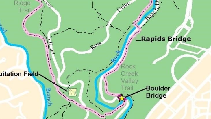
- After hiking along the creek for a half mile, enjoy the view from the center of Rapids Bridge
- Cross Rapids Bridge.
- Turn right on Beach Drive and follow Rock Crek downstream. This will provide you with a beautiful panorama of Boulder Bridge.
- Cross Boulder Bridge and stay on Beach Drive until you come to the gates at the intersection with Broad Branch Road. The trails returning to the Nature Center will be in the trees behind you and to the right. You will see a small white four way sign in the grass. The trailhead to come north is just beyond it.
- Follow the signs for the Western Ridge Trail and take it north back towards the Rock Creek Park Nature Center. You will follow the light green blazes.
- Walk by the horse turn-out at equitation field. Follow the “foot traffic only” signs when the trail veers off the wider horse trail.
- After ¾ of a mile, the trail seems to end at Picnic Grove 13 and a grassy field. Cross the field and the two roads. Hike up the hill to the Nature Center.
Details
Duration
90-200 Minutes
The Boulder Bridge Loop is 3.5 miles with a descent from the Nature Center to the creek. The path along the creek is fairly level with a slight ascent over a hill to get from Rapids Bridge to Boulder Bridge via the Valley Trail. This ascent and descent can be avoided by travelling along Beach Drive which is closed to vehicular traffic on weekends and holidays.
The ascent from Boulder Bridge back to the Western Ridge trail can be challenging for hikers.
The ascent from Boulder Bridge back to the Western Ridge trail can be challenging for hikers.
Activity
Hiking
The Boulder Bridge Loop hike is a 3.5-mile trail that takes visitors down one of the park's bridle trails and accesses the iconic Boulder Bridge via either the Valley Trail (rugged and meant for foot traffic only) or by following the Beach Drive roadway which is closed to visitors on Saturdays, Sundays and holidays.
*Beach Drive is currently closed seven days a week due to the COVID-19 pandemic.
*Beach Drive is currently closed seven days a week due to the COVID-19 pandemic.
Pets Allowed
Yes
Pets are allowed on the Boulder Bridge Loop hike but they must adhere to B.A.R.K Ranger and NPS Pet policies while in the park.
Activity Fee
No
Rock Creek Park is a fee free area.
Location
White Horse Trailhead
The White Horsetrailhead is located to the left of the outdoor riding ring at the Rock Creek Park Horse Center. Follow the signs to the trailhead and the pink duct tape markers on posts to find the trail.
Reservations
No
Season
Year Round
Time of Day
Day
Rock Creek Park is open from sunrise to sunset.
Accessibility Information
Trail starts at the Rock Creek Horse Center where it is roughly six feet across and relatively smooth, though there are occasional roots and rocks. The decent is sustained over half a mile. The bridle trail along the creek rises and falls with the natural terrain along the bank of the creek. The trail crosses Rapids Bridge which is a narrow concrete and metal bridge roughly four feet in width and forty feet across. The most accessible portion of this route is the segment that is on Beach Drive NW between Rapids Bridge and Boulder Bridge. The trail continues up a steep two foot wide foot trail. The ascent is steady and covers several hundred feet in elevation over half a mile. Visitors must once again cross a road stepping up and over curbs. The trail continues along the bridle trails though there are foot traffic only options. The foot traffic only option will be much more rugged and narrow while the bridle trails are wider and slightly smoother. A steep ascent up to another roadway and crossing curbs will bring visitors back to Picnic Grove #13 where additional roads and curbs will need to be crossed to return to the Nature Center.
