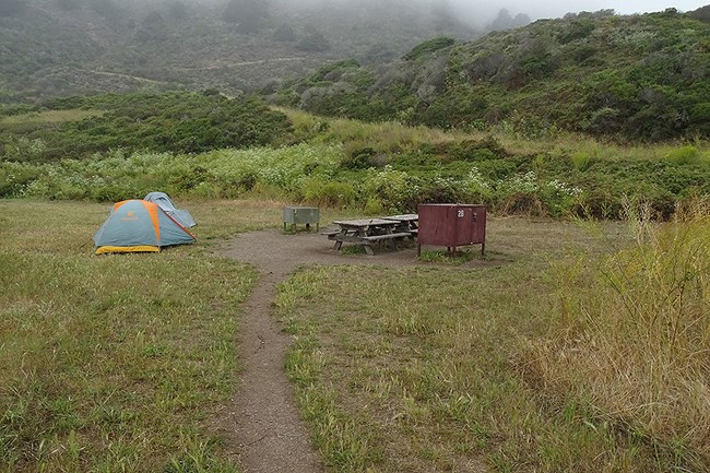
NPS/A. Kopshever Loading...
Basic Information
Amenities Fire/Stove Policy Toilet Types Shower Types Weather Email Address Phone number (Voice) Mailing Address Physical Address Directions Additional Information Cell Phone Additional Information Internet Additional Information Regulations
Image Gallery
Accessibility Information

NPS Photo Site Availability and DirectionsSites available for reservations through Recreation.gov three (3) months to the day in advance: One- to six-person sites #5 & #7 and Group sites #1, #2, & #3 Sites available for reservations through Recreation.gov 14 days in advance: One- to six person sites #4, #6, & #8 Hiking RoutesThere are many potential routes between the Bear Valley Trailhead (geographic coordinates: 38.0398, -122.7994) and Wildcat Campground, the shortest of which is a 10 kilometer (6.3 miles) hike. Overnight parking is available in the gravel parking lot near the trailhead; do not park in the paved lot near the visitor center. Download the Bear Valley Area Map (427 KB PDF), which shows the location of the trailhead parking lot relative to the Bear Valley Visitor Center. Hike through Douglas fir forests along the Bear Valley Trail, before turning left onto the Glen Trail after 5 kilometers (3.1 miles). The Glen Trail climbs out of the Coast Creek Valley, crests a ridge, and connects with the Stewart Trail after 3 kilometers (1.9 miles). Turn right onto the Stewart Trail and descend 1.9 kilometers (1.2 miles) to Wildcat Campground. Along the final 800 meters (0.5 miles), you may have the opportunity to enjoy views of the ocean (if it isn't too foggy). For longer hikes, one can branch off of the route described above onto several different trails and, so long as you generally head south, you will ultimately be able to get to Wildcat Campground. There are many potential routes starting at the Five Brooks Trailhead (geographic coordinates: 37.9974, -122.7579)—all of which are strenuous—climbing through Douglas fir forest up and over Fir Top (elevation 404 m / 1,324 feet). For the shortest route (9.1 kilometers [5.7 miles]), follow the Stewart Trail 1.8 kilometers (1.1 miles) to its junction with the Greenpicker Trail. Bear right onto the Greenpicker Trail and follow it 3 kilometers (1.9 miles) to its junction with the Stewart Trail near Fir Top. From Fir Top, follow the Stewart Trail downhill for 4.3 kilometers (2.7 miles) to Wildcat Campground. Along the final 800 meters (0.5 miles), you may have the opportunity to enjoy views of the ocean (if it isn't too foggy). For longer hikes, one can branch off of the route described above onto several different trails and, so long as you generally head southwest, you will ultimately be able to get to Wildcat Campground. It is an 8.8 kilometer (5.5 miles) hike on the Coast Trail from the Palomarin Trailhead (geographic coordinates: 37.9341, -122.7472) to Wildcat Campground. The Coast Trail passes through alternating coastal scrublands and woodlands, passes by many small lakes and ponds, including Bass Lake, and offers many coastal views. For an alternate route with the same distance, but a couple steeper sections of trail, turn left onto the Ocean Lake Loop Trail after hiking 6.9 kilometers (4.3 miles) along the Coast Trail. After 1.7 kilometers (1.1 miles) the Ocean Lake Loop Trail reconnects with the Coast Trail for the final descent to Wildcat Campground. Please be aware that on weekends throughout the year and on many weekdays throughout the summer, the parking lot at the Palomarin Trailhead fills very early in the day. Visitors arriving late in the morning or in the afternoon may be turned away. The park will close the Palomarin area to further entry, potentially for several hours, when there are no more parking spaces available in the parking lot. Please observe all "No Parking" signs. If you wish to visit Alamere Falls or other locations accessed via the Palomarin Trailhead, arrive early, or consider visiting mid-week. There is only one route to Wildcat Campground open to bicycles and other non-motorized wheeled devices, like wagons. Start at the Five Brooks Trailhead (geographic coordinates: 37.9974, -122.7579). Follow the Stewart Trail 10.7 kilometers (6.7 miles) through Douglas fir forest up and over Fir Top (elevation 404 m / 1,324 feet) to Wildcat Campground. The Stewart Trail has a dirt and gravel substrate. Wildcat Campground is located 1.6 kilometers (1.0 mile) north of Alamere Falls. Follow the Stewart Trail along the south edge to Wildcat Campground to the beach and walk south on Wildcat Beach during a low tide to view the falls. Campground MapDownload the aerial photo/map of Wildcat Campground. (120 KB PDF) |
Last updated: September 18, 2024
