News Release
You are viewing ARCHIVED content published online before January 20, 2025.
Please note that this content is NOT UPDATED, and links may not work. For current information,
visit https://www.nps.gov/aboutus/news/index.htm.

|
Subscribe
|
Contact: John A. Dell'Osso, 415-464-5135
Contact: R.J. Suokko, 415-473-4399
Contact: Nate Allen, 720-963-3668
Point Reyes National Seashore, Marin County — The Federal Highway Administration, Central Federal Lands Highway Division (FHWA-CFLHD), in cooperation with Marin County, California and the National Park Service (NPS), initiated a Subsequent Initial Study (IS) and public comment period to analyze changes to the Sir Francis Drake Boulevard Improvement Project. In accordance with the National Environmental Policy Act and the California Environmental Quality Act, a joint environmental assessment/initial study (EA/IS) was prepared and distributed for public review in July 2015. The EA/IS analyzed improvements to approximately twelve miles of Sir Francis Drake Boulevard in Point Reyes National Seashore (PRNS) within Marin County. A Finding of No Significant Impact/ Mitigated Negative Declaration (FONSI/MND) was issued in August 2015.
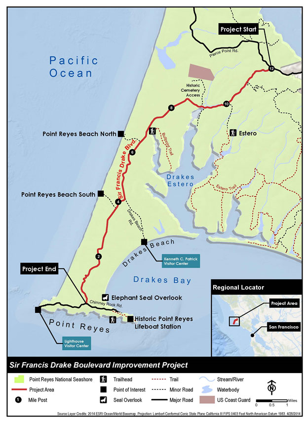
Since issuance of the FONSI/MND, the FHWA-CFLHD has modified the Action Alternative to further improve conditions along Sir Francis Drake Boulevard and to provide detail to the mitigation approach to compensate for impacts identified in the original EA/IS. The FHWA-CFLHD is also actively coordinating with Marin County and state agencies to mitigate upland riparian impacts. Changes to the Action Alternative include: (1) installing a bridge at Schooner Creek; (2) installing biotechnical bank stabilization along a segment of East Schooner Creek; (3) re-establishing a historic wetland at Drakes Beach and reconfiguring the parking lot; and (4) constructing two ponds to provide aquatic breeding habitat for the California red-legged frog. More details are provided below. Attached is the project map.
- The two existing eighty-four-inch diameter corrugated metal culverts at Schooner Creek and Sir Francis Drake Boulevard (project mile [PM] 9.2) would be replaced with an approximately fifty-seven-foot-long, single-span bridge rather than an open-bottom arch structure as initially proposed. Between PM 9.1 and PM 9.3, approximately 750 feet of the roadway would be re-aligned by up to twelve feet to improve safety along the horizontal curves approaching the bridge, and the grade of the roadway would be raised by up to three feet.
- Between PM 10.7 and PM 10.8, a side channel of East Schooner Creek has eroded a portion of the Sir Francis Drake Boulevard roadway embankment. The erosion is degrading aquatic habitat and water quality through deposition of eroded sediment, and creating a risk of road failure.
Approximately 210 feet of biotechnical bank stabilization would be installed to re-establish and stabilize the roadway in this area. The intent of the design is to maintain the side channel in its current location; however, approximately 210 feet of the side channel may be shifted six to eight feet east-southeast from the roadway to ensure its integrity. - To compensate for permanent wetland impacts as a result of roadway improvements, a wetland mitigation site is proposed at the Drakes Beach parking lot. Construction of the parking lot in the 1950s and 1960s resulted in filling a large wetland adjacent to Drakes Beach. Approximately half of the existing parking lot (approximately two acres) would be removed to re-establish the historic wetland. The parking lot would be reconfigured, existing culverts would be cleaned and/or replaced, and a segment of the existing sanitary sewer line located below the existing parking would be realigned and lowered to accommodate the mitigation site.
- Two ponds would be constructed within Home Ranch, one of the historic ranching properties within PRNS, to provide California red-legged frog aquatic breeding habitat and achieve wetland mitigation requirements. The ponds would be constructed by excavating a pond bottom and side slopes, constructing a small dam and emergency spillway, and revegetating with native plants. The first pond would be located approximately 1.25 miles south of the intersection of Sir Francis Drake Boulevard and Home Ranch Road and would be approximately 0.53 acres in size. The second pond would be located approximately 3.5 miles south of the intersection of Sir Francis Drake Boulevard and Home Ranch Road, and would be approximately 0.35 acres in size. Construction equipment access routes would be designated, but no formal access roads would be constructed.
The FHWA-CFLHD is inviting comments from individuals, Federal, State, tribal governments, and local agencies, as well as others interested in or potentially affected by the changes to the action alternative. Your comments will help identify issues and concerns related to these changes. Your participation is important to this process. The comment period is extended to November 6, 2017. Written comments or questions should be submitted to:
FHWA Central Federal Lands Highway Division
Attention: Nate Allen
12300 W. Dakota Ave., Suite 380,
Lakewood, CO 80228
or sent via email.
-NPS-
Last updated: May 7, 2024