Last updated: January 23, 2024
Place
Charlestown Navy Yard Map Sign

NPS Photo/MWoods
Historical/Interpretive Information/Exhibits
Description
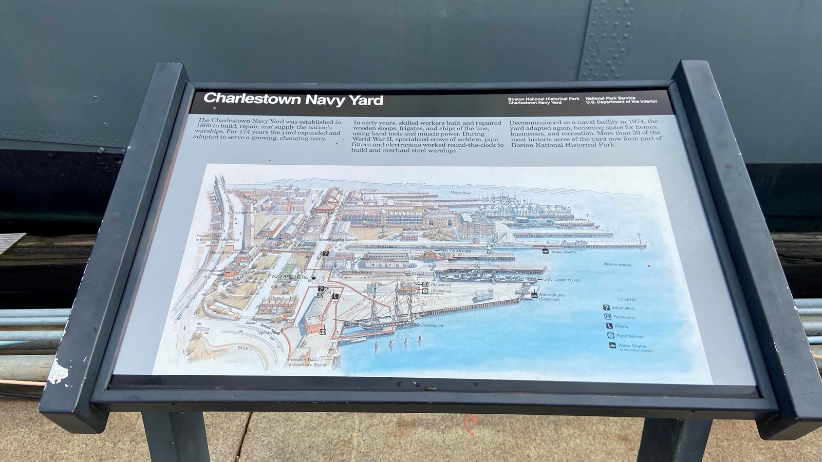
Low-profile wayside that is 40.5 x 24 3/8 inches, with interpretation panel spanning 36.25 inches wide. It has a black semi-cylindrical base with two rectangular pillars supporting the panel. The panel is framed in black metal. The sign is located near Dry Dock 1.
Layout
At the top of the panel is a black banner with white text. The text includes the title, "Charlestown Navy Yard," aligned to the left. Aligned to the right in the banner are two columns of two lines of text. The first column of text is "Boston National Historical Park," followed by "Charlestown Navy Yard." The second column states "National Park Service," followed by "U.S. Department of the Interior." The rest of the panel has a gray background. The top quarter of the wayside below the title banner is text divided over three columns. Below the text is a large color wayfinding map.
Main Text
The Charlestown Navy Yard was established in 1800 to build, repair, and supply the nation’s warships. For 174 years the yard expanded and adapted to serve a growing, changing navy. In early years, skilled workers built and repaired wooden sloops, frigates, and ships of the line, using hand tools and muscle power. During World War II, specialized crews of welders, pipe fitters and electricians worked round-the-clock to build and overhaul steel warships. Decommissioned as a naval facility in 1974, the yard adapted again, becoming space for homes, businesses, and recreation. More than 30 of the most historic acres of the yard now form part of Boston National Historical Park.
Map
Map of the Charlestown Navy Yard oriented with the Mystic River at the top, Boston Harbor to the right, USS Constitution to the bottom, and the Commandant's House and the Freedom Trail leading up to the Bunker Hill Monument to the left. This map is in color with buildings in varying shades of brown and red. The ground is either white or a light tan with grass depicted in green. The legend is to the right in Boston Harbor in black text. It identifies icons for Information, Restrooms, Phone, Food Service, and the Water Shuttle to downtown Boston. Black text identifies some buildings. “YOU ARE HERE” is marked in an open space to the center left of the map. Dry Dock 1 is to the right of this marker and to the left is a road that travels from just below this point to the top of the map. The Freedom Trail begins at the bottom left of the map and runs up through the entrance of the Navy Yard, past a Trolley Stop labeled on the map, and alongside a building on the right. The Freedom Trail turns to the right (below the “YOU ARE HERE” marker) and along the edge of the Building. It turns again to the right, almost boxing in the building. This Building is marked with an Information, two Restroom, and Phone icons. The Freedom Trail line leads to the USS Constitution which is in the water to the right of the Information building. The Trail line continues from USS Constitution up to a building across from the Information building, passing a dry dock labeled Dry Dock 1 on the right. This building is marked as the USS Constitution Museum and has an Information icon. The Trail continues to the left, above the “YOU ARE HERE” marker, and continues up the street and turns left at the first intersection. It continues left along this street, passing the Marine Barracks on its left and the Ropewalk and Muster House on its right. An arrow points the Trail off the left edge of the map with text stating “Freedom Trail to Bunker Hill Monument.” Other buildings of note on the map are identified. Halfway down the pier just above the USS Constitution is a building with seasonal restrooms and food services. At the end of the pier is the USS Cassin Young and a seasonal water shuttle. The Commandant’s House is to the far left of the Yard, overlooking the Navy Yard and the Harbor. Three piers above the first pier is another water shuttle. The rest of the Yard is filled with buildings of varying sizes.
