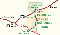
NPS Petrified Forest National Park has a North Entrance off Interstate 40 and a South Entrance off Highway 180. Visitors may enter at one end of the park and exit at the other.
Maps referenced in the Superintendent’s Compendium, showing areas closed to the public for safety concerns and protection of fragile resources. The Newspaper Rock area Map A The Pedestal Log area, Blue Mesa Loop Road Map B The fenced area east of the main park road near milepost (8) Map C Employee housing areas Map D Camping activities Map E Public Assembly at Painted Desert Visitor Center Map F Public Assembly at Rainbow Forest Museum Map G Employee housing areas Map H North cliff area at Blue Mesa Map I Cliff and rock wall that marks the southern boundary of the Hózhó picnic area Map J Battleship Rock, west of Crystal Forest Map K Agate Bridge Map L Petroglyph area at the south end of the Puerco Pueblo Map M Twin Buttes Map N Lands designated as “Guided Only” Map O Golf Course Mesa above Petroglyph Canyon Map P |
Last updated: January 12, 2024