.gif)
MENU
Chapter 1
Introduction
Chapter 2
Urban Development
Chapter 3
Maritime Activity
Chapter 4
Agriculture
Chapter 5
Industry
Chapter 6
Transportation
Chapter 7
Education
Chapter 8
Religion
Chapter 9
Social/Cultural
Chapter 10
Recommendations
Appendix 1
Patterned Brick Houses
Appendix 2
Stack Houses
Appendix 3
Existing Documentation
|
SOUTHERN NEW JERSEY and the DELAWARE BAY
Historic Themes and Resources within the New Jersey Coastal Heritage Trail Route |

|
CHAPTER 2:
URBAN DEVELOPMENT (Continued)
Cumberland County
Cedarville (Cedar Creek)
Situated on both sides of Cedar Creek, a tributary of the Delaware River, Cedarville is four miles from Fairton and eight miles from Bridgeton. The first white explorer believed to have seen the creek was Captain Samuel Argall, captain of the DISCOVERY, which sailed up the Delaware Bay in 1610. In the late seventeenth century, Cedarville was home to such great men as Drs. Jonathan Elmer and Ephraim Bateman, both physicians and congressmen. [21]
Cedar Creek was renamed Cedarville in 1806 with the establishment of a post office. Throughout the nineteenth century the town grew with the development of local industries founded on the locale's natural resources: bog iron, sand, water power, and fertile land. In the early twentieth century, Cedarville was home to three canneries: W.L. Stevens and Brothers, J.E. Diament Company, and Fruit Preserving Company, as well as the Crystal Sand Company. [22]
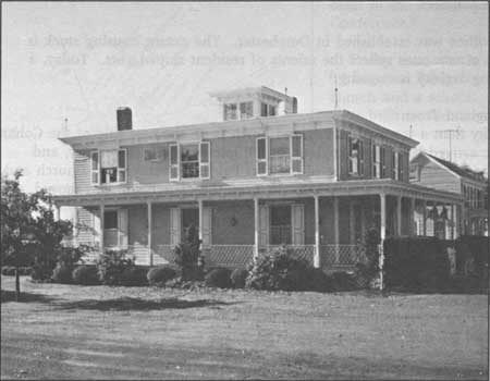
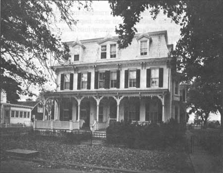
Nineteenth-century prosperity allowed residents to erect fine homes. Although many are vernacular, others express a Victorian love of ornament. An example of this is the Padgett Funeral Home (Fig. 16), a squarish Italianate form with a flat roof, brackets and cupola.
|
| Figure 16. Padgett Funeral Home (19th century) is characterized by its boxy tines, flat roof and Italianate detailing. |
Dividing Creek
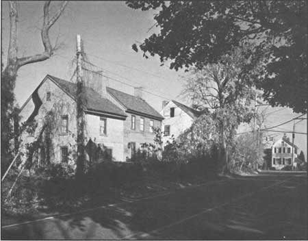
The first settlers to the Dividing Creek area probably came from Fairfield in the early eighteenth century; Baptists were here before 1749. As early as 1763 a bridge was erected over Dividing Creek, for which the town was named, near where it divides into several branches. [23]
In the nineteenth century many Dividing Creek residents worked in the oyster industry. In 1881 a marine railway for the repair of oyster boats was opened by John Burt, George Sloan, and M. Howell. In the early twentieth century, the most substantial extant industry was M.J. Dilk's sawmill. In addition to general lumber products, Dilk made peach and garden truck baskets. [24] The prosperity of the last century made Dividing Creek a stop on the Central Railroad of New Jersey and a switching station for the Bridgeton and Port Norris Electric Trolley Company. The trolley cars ran along Main Street, perpendicular to the creek. Most houses are vernacular, located on the west side of the creek, and were erected in the nineteenth century. Also in place is a Baptist church, organized in 1755, and a Methodist church of 1830. [25]
Dorchester
Located along the Maurice River about three-and-one-half miles from Port Elizabeth, Dorchester was part of an early survey undertaken by John Worledge and John Budd in 1691. In 1799 Peter Reeve bought part of this land, laid out Dorchester, and sold lots. [26]
During the nineteenth century, shipbuilding was the principal occupation of townspeople, at two yards: Blew and Davis, and Baner and Champion. The latter was rented to the Vannaman Brothers of Mauricetown in 1882; they constructed large three-masted schooners here. At the turn of the century, the shipyards were operated by Charles Stowman and Son, and John R. Chambers.
In 1882 a post office was established in Dorchester. The extant housing stock is nineteenth century—the ornate ones reflect the talents of resident shipwrights. Today, a minimum of shipbuilding activity is ongoing. [27]
Fairton/New England Town
More of a locality than a town, New England Town is on the east side of the Cohansey River. The first settlers arrived from New England in the late seventeenth century, and evidence of their presence is found at the site of the first Fairfield Presbyterian Church and graveyard, on Back Neck Road just off Route 553. In 1780 the church site was moved, and the congregation built the Old Stone Church. [28]
Considered locally as part of the area called Fairton/New England Town, this village boasted gristmills and sawmills throughout the eighteenth century. Fairton gained its name in 1806 when a post office was established here. Throughout the nineteenth century it grew to became a cultural center for the surrounding farmers. Like other Cumberland County towns, many men worked in the oystering industry, in addition to Furman R. Willis's beef and pork packing house, Richard M. Moore Glass Company, Whitaker & Powell canners, and Crystal Lake Milling Company. [29]
The mid to late nineteenth-century houses in Fairton reflect its era of growth and development. Little has changed today, with the houses along Route 553 remaining primarily intact. The town is associated with a local marina as well as nearby farms.
Gouldtown
Gouldtown, located about two-and-one-half miles east of Bridgeton on Route 49, was founded as a mulatto community. According to local tradition, the Gould family were mulatto descendants of John Fenwick. His grand-daughter, Elizabeth Adams, allegedly married a black man named Gould. Upon his death, she inherited 500 acres from whence Gouldtown was established. Benjamin Gould—who may or may not have been Elizabeth's son—then founded the town. [30] When Gould reached the area he bought 249 acres, making him one of the first blacks to own property here.
In 1820 a Methodist society was formed in the town, and in 1861 a church and school were built; in 1873 a post office was established. Several regionally prominent men who came from Gouldtown were descendants of its founder, among them Theophilus G. Steward, U.S. Army chaplain and writer; William Steward, newspaperman and an author; Bishop Benjamin F. Lee, president of Wilberforce University in Ohio; and Theodore Gould, presiding elder in the Philadelphia Methodist Conference. [31]
Today the town is a crossroads on Route 49 between Bridgeton and Millville with a church and a school. Many of the structures were built in the twentieth century.
Greenwich
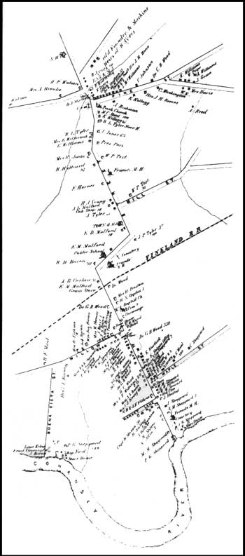
|
| Figure 17. Map of Greenwich, Atlas, 1876. |
In 1683, shortly before John Fenwick died, he undertook plans for a town called Cohansey on the river of the same name. Ye Greate Street was surveyed in late 1683, and in February 1684 the first lots in Greenwich (Fig. 17, pronounced Green-witch) were sold; Fenwick willed the first two lots to his friend Martha Smith. The first settlers in the town were Quakers and Baptists, and in addition to being a farming community, maritime activities led it to be named a port of entry in 1687. [32] Named after Greenwich-on-Thames, the village today is a well-preserved colonial hamlet with all its structures (1686-1918) listed in the National Register of Historic Places district—which encompasses Ye Great Street to the village of Othello. A monument in town commemorates one significant event indicative of Greenwich's early importance.
In December 1774, shortly after the Boston Tea Party, the brig GREYHOUND arrived in Greenwich loaded with tea. The captain feared that if he attempted delivery to Philadelphia the cargo would be burned, so he hid it in the home of English sympathizer Dan Bowen. The majority of the county chose to support the Continental Congress's decision to resist taxation without representation, however. Enraged Greenwich citizens learned of the hidden tea, and on 22 December, whites disguised as Indians captured and burned it in Greenwich's town square. Among the participants were Richard Howell, Philip Vickers Fithian, Andrew Hunter, and Ebenezer Elmer, who subsequently served in the revolutionary ranks. The tea party was a major event in Cumberland County during the war.
Among the many fine examples of patterned brick work in Greenwich are the Nicholas Gibbon House (1730), Richard Wood Mansion (ca. 1795), Vauxhall Gardens (1698), and Bowen House (1765). [33] Many buildings in town were recorded by HABS/HAER in the 1930s.
Haleyville
Located one mile west of Mauricetown, Haleyville consists of a series of primarily nineteenth-century vernacular houses on either side of Route 676. Its agriculture-based community centered around the Methodist church, established in 1810. At mid-century, the town erected and supported a public school. Both structures are extant today, though the school is used as the office of a cable company. A post office was established in 1873, but it no longer exists.
Heislerville
As early as 1800, the people who lived in this area met in the local school for church services. In 1828 an Methodist Episcopal Church was organized here, and the Heisler family was a prominent element of the congregation. The town, named for them, grew during the nineteenth century. [34] Many residents were watermen, as the town is located where the Maurice River enters the Delaware Bay. Much of the commercial activity consisted of oystering, with limited vegetable and berry farming. [35] In the late nineteenth and early twentieth century, Heislerville's population rose from 100 to 450; at that time a post office was established, and the West Jersey and Seashore Railroad (Maurice River Branch) passed within one mile of the town.
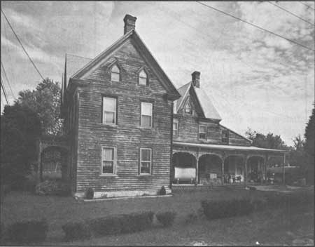
Today the town is a modest crossroads village en route to East Point Lighthouse. One impressive Gothic Revival house (Fig. 18), at the corner of Main Street and Glade Road, reflects the prosperity that once existed here. This mid to late nineteenth-century dwelling may have been a stage stopover. Its location is critically close to the East Point area, which served as a resort complete with hotel and restaurant; the hotel, located west of the lighthouse, burned in 1900. [36]
|
| Figure 18. This Heislerville house (19th century) has fine Victorian elements in its pointed Gothic windows, gables, and spindlework trim; a store was in the rear. |
Jericho
Located on the southeastern side of Stow Creek, the dividing line between Cumberland and Salem counties, the land that became Jericho was purchased in 1680 by John Brick. He and his family were the first settlers in the area, and established gristmills and sawmills. As time progressed, Jericho developed as a location on the road from Bridgeton to Salem via Roadstown. [37]
John Wood, mill owner and entrepreneur, attempted to increase the importance of Jericho during the early nineteenth century; in 1818, as a partner with New York businessman John E. Jeffers, he opened a woolen mill. Jeffers backed out of the project, however, and the machinery was sold in 1830. In 1883, the town had less than 100 residents and no major businesses. [38] Today Jericho is a crossroads off of Route 49.
Leesburg
The land that later became the town of Leesburg in the late eighteenth century also was surveyed by John Worledge and John Budd in 1691. Similar to Dorchester, the first settlers to the area were most likely Swedish, though a town was not established until 1795 when John Lee, an Egg Harbor shipwright, founded Leesburg. In doing so, he and his brothers opened the first shipyard—and with it established the industrial destiny of constructing coastal vessels. In 1850 James Ward built a marine railway here to facilitate the repair of larger ships, which were attracted to Maurice River site because it was only six miles from the Delaware Bay. [39]
Though Leesburg's economic base was primarily shipbuilding, two successful early twentieth-century industries were the Leesburg Packing Company, a cannery that seasonally employed 100 persons, and J. C. Fifield and Son, a fertilizer works. Today the only evidence of these industries is WHIBCO Inc., a sandmining company whose administrative offices occupy the buildings of the former Del Bay Shipyard (Figs. 26-27). [40]
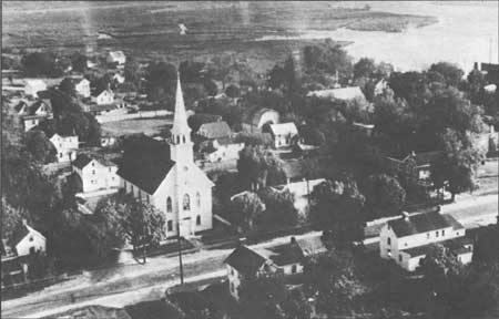
Mauricetown
Prior to the 1880s when the oyster industry boomed in Port Norris, Mauricetown (pronounced Morris-town) was the largest and most active center in Commercial Township (Fig. 19). In 1780 Luke Mattox bought land, constructed a landing, and called the area Mattox's Landing. He and others shipped cord wood and lumber from the wharves along the river. In 1814 the Compton brothers bought land here, platted out a town, sold lots and erected houses. By then it was called Mauricetown, due to its riverside location, and as such became the home to several shipyards. One of the first belonged to Joseph W. Vannaman and the captains of ocean-going schooners. The latter dealt some in the oyster trade, though they were more likely to have been associated with shipping lumber and other goods.
|
| Figure 19. Mauricetown, named for its Maurice River site, is composed of well-preserved structures that deem it worthy of listing in the National Register. Wettstein, ca. 1950s. |
In the mid to late nineteenth century, Mauricetown was known for its population of wealthy sea captains. The grandeur of their Italianate or Gothic Revival-style houses reflects the craftsmanship and lucrativeness of the industry—and the houses remain more often than not virtually intact. The most ornate examples parallel the river on Front Street, including the Ichabod Compton House (1812, Fig. 20), the Captain Samuel Sharp House (ca. 1860), the Captain Maurice Godfrey House (ca. 1870) and the Captain Charles Sharp House (ca. 1860).
|
| Figure 20. Ichabod Compton (1782-1833), a descendent of the founders of Mauricetown, a waterman and sawyer, lived in this dwelling. |
Today, the collection of dwellings, churches, and a school are uninterrupted by modern intrusions. Mauricetown possibly warrants listing as a National Register of Historic Places district.
Newport
Located below Cedarville, Newport sits on the south side of Nantuxent (Autuxit) Creek. The earliest record of settlement here is the will of William Mulford, 28 July 1719, which refers to his plantation on Autuxit Creek. By the middle of the eighteenth century, the town had a hotel, sawmill, and gristmill—the latter located on Page's Run, a branch of the creek. The town got a post office in 1816. The oyster industry employed many Newport men in the late nineteenth century who, like wealthy Port Norris residents, built Victorian homes or "modernized" existing dwellings. Today these remain a symbol of the last century's prosperity. [41]
Othello/Head of Greenwich
This village is essentially the northern extension of Greenwich's Ye Greate Street, and features a Quaker meeting house and Presbyterian church. Built in the 1830s, the former was home to the Hicksite Quakers who broke from the Orthodox sect in Greenwich. The Presbyterian church was organized prior to 1747; the present Greenwich Presbyterian church appears to have been built in 1835. One prominent Presbyterian from this area is Philip Vickers Fithian, a Princeton graduate and minister. Like Greenwich, the structures in Othello date to the eighteenth century.
During the late nineteenth and the early twentieth century, Othello was the site of the Pennington Seminary, a large private school that attracted boys and girls from all over the county. Industries here included: the Union Boiler Company, which employed eighty men, and the Pennington Cannery, with a work force of forty men and women during canning season. [42]
These historic homes and structures are listed on the National Register as part of the Greenwich Historic District. Two more important resources are the cemetery associated with the Presbyterian church and a cemetery just north of here that contains the graves of several black Civil War veterans.
Port Elizabeth
Port Elizabeth, on the Manamuskin Creek, a tributary of the Maurice River, was one of the first Cumberland County settlements established as early as 1750. In 1771 the land on which the town is located was bought by Elizabeth Bodley, after whom it is named. She then laid out streets and lots and began to sell them; the first lot was deeded to the Methodist Episcopal Church. During the late eighteenth century, the town became a port of delivery, where duties on foreign imports were collected. At the same time, the town acquired its first hotel and a road was built to Tuckahoe, with Port Elizabeth serving as the eastern landing of the Spring Garden Ferry, which linked the east and west banks of the Maurice River. [43]
The first entrepreneurs here were James Lee and his half brother Thomas, both of Chester County, Pennsylvania. In 1801 the Lees established a factory for the manufacture window glass. Ownership of the works changed hands several times throughout the nineteenth century and it was closed by the early twentieth. By 1850, however, the town included a post office, school, and three churches. Many of the dwellings reflect the town's development in the middle to late nineteenth century. As with most area towns, the houses are vernacular with little ornamentation. [44]
Port Norris/Bivalve
See Chapter 3: Maritime.
Roadstown
An early stop on the first stage lines between Greenwich and Camden, and Bridgeton and Salem, Roadstown was first called Kingstown; later it was known as Sayre's Cross Roads, after Ananias Sayre, a prominent citizen and county sheriff. Since the early nineteenth century it has been called Roadstown (Fig. 21). [45] Settled by the British in the early seventeenth century, Roadstown ranked in importance next to Greenwich, Fairton/New England Town, and Bridgeton/Cohansey's Bridge.
|
| Figure 21. Roadstown is the site of the Ware chairmaking family as well as several patterned brick houses. |
Today the town is noteworthy for two reasons. First, it was the home of the Wares, a multi-generational family of chairmakers whose ladderback, rush-bottom chairs are now highly valued among collectors. It is also an area rich in patterned brick houses with their construction dates and builder's initials in the gable. Included among these are the David Bowen House (1770), Ananias Sayre House (1770), and Daniel Bowen House (1775); just outside of town on Route 626 is the John Remington House (1728). [46]
Shiloh (Cohansey Corners)
The town of Shiloh lies in Hopewell and Stow Creek townships on property that was part of a survey by Dr. James Wass, and in 1705 was bought by Robert Ayers, a Seventh-Day Baptist. He laid out lots and sold them to other Seventh-Day Baptists; the town has remained affiliated with this sect, and the history of the church coincides with that of the area. The church was organized as early as 1737, and Shiloh became the nucleus around which these Baptists gathered (Fig. 22). [47]
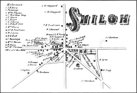
|
| Figure 22. Map of Shiloh, Atlas, 1876. |
In 1841 a post office was established here. The Union Academy opened in 1849 with a curriculum oriented toward agricultural teachings. The industrial focus of the town mirrored the area's agricultural importance. In the late nineteenth century, several canneries employed residents, including that of Davis and Rainear, which operated in this century. [48]
Today, Shiloh's structures depict a once-bustling crossroads. At the intersection of Routes 49 and 696 there are two general stores and a service/gasoline station. The houses, however, reflect the heyday of community, having been erected in the eighteenth and nineteenth centuries. The academy building is extant, as is the DeCou's Farm Market and Packing Business, which operates at the east end of town.
Springtown
Springtown is in the northeastern part of Greenwich Township along the Greenwich-Bridgeton road. The community was founded in the nineteenth century as a haven for runaway slaves from Maryland and Delaware. That Springtown began as a haven for fugitive blacks distinguishes it from other area black-settled communities such as Gouldtown and Bridgeton. The town gets its name from a former slave, possibly Andrew Springer, who arrived here in the early nineteenth century with other runaways. The Quakers of Greenwich encouraged them to form their own community. Once it was established, Springtown may have been a stop along Harriet Tubman's Underground Railroad. [49]
By the twentieth century, the number of residents had declined such that the town could not support its three schools; only one survived in 1908, with fifty pupils. The three churches in town had so few members that they could not form a full congregation. The falling population was a result of the black migration to cities—Bridgeton, Philadelphia, Wilmington, New York—in search of work. Today there is little left of Springtown except for a few houses, the Wesley Methodist Episcopal Church, and the Bethel AME Church. [50]
Continued >>>
 Top
Top
Last Modified: Mon, Mar 14 2005 10:00:00 pm PDT
http://www.nps.gov/history/history/online_books/nj2/chap2d.htm
![]()