.gif)
MENU
Chapter 1
Introduction
Chapter 2
Urban Development
Chapter 3
Maritime Activity
Chapter 4
Agriculture
Chapter 5
Industry
Chapter 6
Transportation
Chapter 7
Education
Chapter 8
Religion
Chapter 9
Social/Cultural
Chapter 10
Recommendations
Appendix 1
Patterned Brick Houses
Appendix 2
Stack Houses
Appendix 3
Existing Documentation
|
SOUTHERN NEW JERSEY and the DELAWARE BAY
Historic Themes and Resources within the New Jersey Coastal Heritage Trail Route |

|
CHAPTER 2:
URBAN DEVELOPMENT (continued
Cape May County
Cold Spring
Cold Spring, established as early as 1688, gets its name from the freshwater spring that bubbled up through the salt marsh. Indians used the water for years, and passed on its value to the Europeans. The "cool spring water was retrieved by lowering a corked bottle into the spring, then pulling the cork out allowing the bottle to fill with fresh water." Prior to the early 1800s a shed covered the spring; this was replaced by a series of nineteenth-century gazebos that burned. [51]
During the early eighteenth century, the land Jacob Spicer owned around the spring was also the site of his plantation. After the community developed it became a stagecoach stop. In the early eighteenth century Cold Spring Presbyterian church was organized, and in 1718 a log church was constructed. The present brick church on Seashore Road was built in 1823; five years later the Cold Spring Hotel opened between Cold Spring and Cape Island. In 1857 the Cold Spring Academy was founded under the direction of Reverend Moses Williamson. This was the first school in the county to teach high-school level courses. Today, of these buildings only the church is extant. The spring, located in an obscure place along Route 9, is still active and is witnessing the construction of a new gazebo. [52]
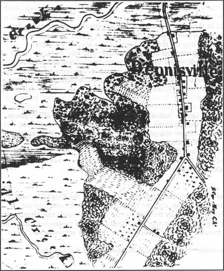
Dennisville/North Dennis/South Dennis
The areas that today consist of Dennisville, North Dennis, and South Dennis were collectively known as Dennis Creek until the second half of the nineteenth century (Fig. 23). Dennisville/Dennis Creek was deeded to John Dennis after he purchased the land from an Indian named Panktoe in 1687. Sometime between the 1690s and 1726, Jacob Spicer owned the land; in 1726 he sold it to Joseph Ludlam. Ludlam's sons, Anthony and Joseph, settled on both sides of the creek, and the foundations of the town were in place. [53]
|
| Figure 23. Map of Dennisville. US. Coast Survey, 1842. |
Industrially, Dennisville is known for two things: lumber and ship building. Many residents mined cedar trees out of the local swamps. The trees were cut for siding and shingles—much of which was exported via schooner. Among the lumber mills that existed in the early twentieth century were those of Ogden Gandy, Jesse D. Ludlam, and Derien & Campbell. [54] Associated with the cedar lumbering, Dennisville boasted several talented shipwrights. Two important shipyards were the Leaming Yards and the Isaac Gandy and Jesse Diverty shipbuilding operation. Ships were built lengthwise along the narrow creek and launched sideways into the water, moving farther out with each high tide. [55]
Several prominent captains acquired great wealth from shipping lumber and produce. These men, in turn, built elegant frame homes that date to the late eighteenth and nineteenth centuries. Today, sixty-nine sites are included in the Dennisville Historic District; fifty-eight are historically significant. In addition to its houses, Dennisville is known for being the first Cape May County town to have a post office, established in 1802. [56]
Goshen
One of the oldest towns in the county, Goshen was first settled in 1693: Aaron Leaming (the first of nine men of that name) raised cattle here. A cluster of houses appeared in 1710, and it became a stagecoach stop on the Philadelphia-Cape May route. Like Dennisville, Goshen's industrial history centered around lumbering and ship building. Some of the shipyards were along Goshen Creek, where the vessels were, again, launched sideways because of the narrow channel. The town was fifth in the county to receive a post office. [57] Today, Goshen consists of several houses, a post office, two churches, a school, municipal building, and filling station, primarily along Route 47/Delsea Drive.
Nummytown
Named after King Nummy, a Lenape Indian chief, the area that includes Nummytown, Dias Creek, Cape May Court House, Fishing Creek, Mayville, Cold Spring, Wildwood, and Tuckahoe were Indian campgrounds. These villages were the destination of Indians making their summer migration to the shore to collect seafood and wampum. The local Indian population never exceeded 500, and thus did not threaten white settlers. By 1735 most of the Indians from here had migrated north. [58] Today, much of what was Nummytown has been developed into campgrounds, shopping areas, and residential neighborhoods.
Rio Grande/Hildreth
Rio Grande was originally the intersection of the earliest roads: the King's Highway (Shore Road) from Tuckahoe to Cold Spring, and the road from Dennisville and Goshen (Delsea Drive). The town developed gradually throughout the late eighteenth and nineteenth centuries, first as a stagecoach stop and later as the last railroad stop for passengers bound for the beach resorts; vacationers traveled from Rio Grande to the shore via stagecoach. [59]
Unlike Goshen and Dennisville, the industrial innovations aided Rio Grande's development. While the other two declined in importance because they could not access the railroad, Rio Grande embraced rail and automobile traffic. In the early twentieth century, two industries were here: Rio Grande Canning Company and J.S. Brown carriage factory. [60] Today Rio Grande, too, like its neighbor Nummeytown, is recognized by its strip shopping malls, small businesses, and residential development. Few remnants of its early history remain.
Town Bank/Portsmouth/New England Village
Town Bank was originally settled by New England whalers who came here on a seasonal basis. As time passed, however, more of the whalers stayed year-round and eventually moved inland. In 1692 the town was made the first county seat, though it diminished in size and importance as whaling dwindled and the Delaware Bay reclaimed coastal lands. The site of the original Town Bank is underwater; the current Town Bank is an unrelated residential community. [61]
Cape May, Salem, and Cumberland counties are peppered with small, rural towns that in general retain a good portion of historically significance buildings. The most exemplary are Dennisville, Greenwich, and Mauricetown where there has been little modern intrusion. Despite some contemporary alterations and new construction, the historic cores of Salem and Bridgeton area are also characterized by its historic appearance. Towns that do not have designated historic districts should be considered for further investigation. Among the fast-food restaurants and modern offices in Millville and Pennsville a variety of historic structures are extant that should be studied for their historic value. Small towns such as Cedarville, Newport, Dividing Creek, Fairton, Quinton's Bridge, and Hancock's Bridge also feature a number of historic resources that warrant study and consideration for historic designation.
Notes >>>
 Top
Top
Last Modified: Mon, Mar 14 2005 10:00:00 pm PDT
http://www.nps.gov/history/history/online_books/nj2/chap2e.htm
![]()