
NPS Image The park brochure is available at all entrance stations and visitor centers. It can also be accessed in a variety of formats: Park Brochure Format: PDFDownload a PDF of the park brochure. A larger resolution version of the park map on the back side of the brochure can be downloaded from NPGallery. The park brochure map is also available on the maps page. Park Brochure Format: BrailleDownload this brochure as a printable Braille file. Please note, you must have access to a Braille printer to make use of this file.Printed Braille versions of the park brochure are available at entrance stations and some visitor centers. Park Brochure Format: UniD Mobile App for Audio DescriptionExperience the park brochure through the UniD mobile app, which has been designed to be the most efficient and effective method for accessing the audio description material of the park brochure. The app makes available all of the park brochures created within UniD (more than 50 to date, across the country), including Mount Rainier National Park.
NOTE: The UniD app automatically downloads park content (its texts and Mp3s) when the app is opened and the particular park file is selected (while online). Once downloaded the content is available in the app, even with no connectivity. Park Brochure Format: MP3 Audio DescriptionDownload a folder of audio files. Open the files in your preferred mp3 player to listen to each section of the brochure.Park Brochure Format: Text Only DescriptionWelcome to the audio-described version of Mount Rainier National Park's official print brochure. Through text and audio descriptions of photos and maps, this version interprets the two-sided color brochure that visitors receive when they visit Mount Rainier. The brochure explores the natural and cultural history of the park and provides information for planning your visit. This audio version lasts about 46 minutes which we have divided into 46 sections, as a way to improve the listening experience. Sections 2 to 29 cover the front of the brochure and highlights the different park areas and things to do. It also introduces the park's dynamic natural environment and long cultural history. Sections 30 to 46 cover the back of the brochure, which consists of a detailed park map along with park safety and trip planning information.
Mount Rainier National Park, located in Washington state, is part of the National Park Service, within the Department of the Interior. The 236,380 acre park is situated sixty miles southeast of Seattle, Washington, in the southern Cascade Mountains. Established in 1899, Mount Rainier is the fifth oldest national park. Each year, over two million visitors travel the park's historic roads to view the tallest volcano in the continental United States. We invite you to explore the park's old-growth forests, subalpine wildflower meadows, and dynamic landscape carved by glaciers and powerful rivers. For those seeking to learn more about the park during their visit, join a ranger-guided walk or listen to an audio described tour of the park's main visitor centers. To find out more about what resources might be available or to contact the park directly, visit the "Accessibility" and "More Information" sections at the end of this audio-described brochure.
The front side of the brochure has a vertical orientation. Rows of text and photos stretch across the brochure. A quote from John Muir is at the top with a night sky photo of Mount Rainier. Below that is a text section introducing the park. Below that is a section labeled "Unforgettable Destinations" featuring a photo and short text description for each of the five developed park areas. Below that a section labeled "Discoveries Await" is filled with two rows of photos of the park. Finally, the bottom section is broken into three parts that highlight the wilderness, cultural history, and dynamic nature of the mountain.
Of all the fire mountains which like beacons, once blazed along the Pacific Coast, Mount Rainier is the noblest.
- John Muir DESCRIPTION: A night photo of Mount Rainier stretches across the entire width of the top of the brochure. On the left side behind a jagged rocky mountain ridge line, a slice of yellow sky fades to orange then into a purple-blue night time sky streaked with stars. The starry sky over the mountain's left side provides the backdrop for the John Muir quote. The mountain rises into a peak on the right side of the brochure, with the mountain slopes faintly lit from the right by fading light. From the rounded summit, a glacier flows down the slopes of the mountain, broken by crevasses and rocky outcrops. A few pinpoints of bright lights trace up the left-side ridge of the mountain. The base of the image fades to black and provides the backdrop for the brochure's introductory text.
CAPTION: Moving up Mount Rainer's glaciers and lava ridges, their routes illuminated by headlamps, climber travel steadily toward the summit under a star-filled sky. CREDIT: Copyright Jeff Berkes RELATED TEXT: A mountain of immeasurable inspiration, Mount Rainier is the center of the nation’s fifth national park. It is a place of discovery and of personal triumphs, where family traditions endure. At 14,410 feet, the mountain is the tallest volcano in the Cascade Mountain Range and the most glaciated peak in the continental United States. Basalt columns and other remnants of early eruptions and lava flows reveal Mount Rainier’s ancient geologic history. Glaciers, massive rivers of ice up to 750 feet deep, flow down the rocky slopes. Yet, on the summit, steam escapes from deep within the mountain’s core, a reminder that it is still an active volcano. Above Mount Rainier, millions of stars illuminate the night sky. The park minimizes the use of artificial light. This preserves darkness, through which constellations and planets are remarkably visible. In spring, snow melts first in the foothills. Beneath the old growth forest, flowers bloom and ferns unfurl. Across the subalpine region, summer may only last two months. Adaptations that have taken centuries to develop prove crucial in a race for survival. Profuse wildflower displays and pollinating insects bring life to the meadows. Birds and mammals forage on the abundance before winter quickly returns. Entering the park is a step back in time—a portal into Mount Rainier National Historic Landmark District. Roads, buildings, and other structures were designed nearly one hundred years ago. Massive logs and round river boulders characterize early national park rustic architecture, which harmonizes with the park’s natural scenery. For thousands of years, Mount Rainier has been an important place for Pacific Northwest Indigenous people. Nearly two million people from around the world now visit Mount Rainier National Park each year. As global development increases, this mountain remains steadfast, a place where people can reconnect with what is important in their lives. This section briefly describes some of the park’s major areas, including Longmire, Paradise, Ohanapecosh, Sunrise, and Carbon River.
DESCRIPTION: A photo of a two-story building nestled in the forest and framed by red vine maple foliage. The bottom story of the building is built from large rounded boulders, while the top story is built of wood logs, with a wood shingled roof. Both stories have rows of windows with white trim. The entrance is shaded by a porch with large log beams supporting the wood-shingled porch roof. A yellow log sign hangs from underneath the porch roof. A gravel path leads to the entrance across a green lawn.
CAPTION: Longmire is a year-round destination CREDIT: NPS RELATED TEXT: Accessible year-round. Snowshoe or cross-country ski during winter. Stroll the edge of a meadow where history meets nature. Day hike to expansive vistas. Step back in time; discover rustic park architecture along the Longmire Historic Walking Tour. Stay a night at the historic National Park Inn. From the porch, admire the sunset’s glow on the mountain DESCRIPTION: Colorful wildflowers fill the bottom third of a photo. Purple-pink subalpine daises, dark blue lupines, magenta paintbrush, and yellow spikes of partridgefoot bloom with lush green vegetation. Behind the flowers stretches a rocky ridgeline with patches of snow. Behind the ridge, the glaciated peak of Mount Rainier can be glimpsed through a gap in low clouds that wrap around the mountain.
CAPTION: Visit Paradise meadows when they are at their most spectacular. CREDIT: NPS/Jasmine Davis RELATED TEXT: During summer, hike the maintained trails around meadows, streams, and waterfalls. Watch and listen for wildlife—bears, grouse, butterflies, marmots, and more. Explore exhibits at the visitor and climbing information centers. Rest a night or have a snack at the historic Paradise Inn. Grab a sled and head for Paradise’s winter snowplay area, set up a snow camp, ski, or snowboard. DESCRIPTION: A tent with a green rain fly set up on ground covered in conifer needles. Behind the tent, an empty hammock stretches between two trees in the shade.
CAPTION: Camp, hike, and explore beneath towering old growth trees. CREDIT: Copyright Daniel Wyknenko RELATED TEXT: Old growth forest is the signature of Ohanapecosh. Ancient trees, wildlife, waterfalls, spring wildflowers, and fall mushrooms abound. The Ohanapecosh River—transparent green or blue depending on the light and your perspective—surrounds the Grove of the Patriarchs. Many day hikes begin at Ohanapecosh. Camp or picnic in the campground. DESCRIPTION: Mount Rainier dominates the landscape in this photo, rising far above the surrounding ridges. Starting from the summit, a glacier carves down the side of the mountain, spliting halfway around a triangular promontory. The left side glacier continues to flow down the side of the mountain into a wide river valley bordered by large glacial moraines and forested hillsides. The remaining glacier splits to the right and disappears behind a rocky ridge covered in patches of snow. The ridge widens as it descends the slope of the mountain. Rocky ground transitions into a carpet of green subalpine meadow broken by patches of subalpine fir trees. A narrow road winds through the meadow, ending at a small cluster of buildings.
CAPTION: Enjoy unsurpassed, panoramic views while hiking amid resplendent subalpine meadows CREDIT: NPS/John Chao RELATED TEXT: Sunrise, the highest point in the park reachable by car, offers a panoramic view of Mount Rainier and surrounding peaks. Day hikes lead to glaciers, lakes, and meadows. Dig into geology at the visitor center. Discover the rustic architecture and history of Sunrise. Enjoy a snack at the day lodge. Camp nearby at White River Campground. DESCRIPTION: A man wearing a backpack leans forward to look through the view finder of a large camera set up on a tripod. The tripod straddles a narrow trail leading through dense forest illuminated by small patches of sunlight. The forest ground is covered in moss, ferns, skunk cabbage leaves, and other vegetation.
CAPTION: Capture the lush vegetation and giant old growth trees of the rainforest. CREDIT: NPS/John Chao RELATED TEXT: Meander moist, moss-carpeted paths through temperate rainforest. Discover the dynamic forces of a glacial river. Mountain-bike a historic road. Spend a night in the backcountry. Visit Mowich Lake—the park’s largest and deepest lake. Camp near the lake or enjoy its serenity from a canoe. Fish the deep waters. Hike to subalpine meadows. This label introduces the bottom half of the front of the brochure.
DESCRIPTION: A photo of old-growth forest stretches across the entire width of the middle of the brochure. On the left side a massive moss and lichen-covered tree trunk dwarfs a female hiker passing by it on a trail. The hiker, wearing a backpack and holding two hiking poles, heads towards the camera. The trail stretches away behind her into the forest. To the right, the dense forest fades away and becomes the background for two rows of photos.
CAPTION: Hike amid ancient trees and past waterfalls on the Eastside Trail. CREDIT: NPS/Chris Roundtree This set of six photos features views of Mount Rainier, visitors hiking and snowshoeing, and natural scenes including a lake, a forest, and a mountain goat. The photos have white borders and are set at odd angles and slightly overlap as if scattered across the page in a loose row.
IMAGE 1 of 6 DESCRIPTION: Wisps of clouds cling to the rocky ridges and glacier-covered summit of Mount Rainier. The ridges and lower elevation forests are dusted in snow.
CAPTION: View from Ricksecker Point CREDIT: NPS/Steve Redman IMAGE 2 of 6 DESCRIPTION: Two backpackers walk along a narrow trail through a lush subalpine meadow filled with colorful wildflowers and bordered by fir trees. Behind them, the valley is framed by rocky ridges scattered with patches of snow.
CAPTION: Wonderland Trail CREDIT: Copyright Nick Postorino IMAGE 3 of 6 DESCRIPTION: Four snowshoers ascend a snowy hillside between subalpine fir trees drooping from a heavy blanket of snow. The bright red and blue clothing of the snowshoers stands out against the white, snow-covered landscape.
CAPTION: Winter at Paradise CREDIT: Copyright Deby Dixon IMAGE 4 of 6 DESCRIPTION: A turquoise subalpine lake surrounded by forested hillsides. A few conifer trees grow on the edge of the lake.
CAPTION: Mowich Lake CREDIT: NPS/Melinda Schmitt IMAGE 5 of 6 DESCRIPTION: A massive cedar with grooved, weathered bark and a thick trunk supports drooping branches. A hiker, tiny in comparison to the cedar tree, sits against the base of another tree and looks up at the old-growth giant.
CAPTION: Grove of the Patriarchs CREDIT: NPS/Chris Roundtree IMAGE 6 of 6 DESCRIPTION: A mountain goat with a shaggy white coat and two short horns steps onto shrubby alpine plants next to a snowfield.
CAPTION: Mountain Goat CREDIT: NPS/John Chao This set of five photos features views of Mount Rainier and natural scenes including a deer in a meadow, a river canyon, and a black bear. The photos have white borders and are set at odd angles and slightly overlap as if scattered across the page in a loose row.
IMAGE 1 of 5 DESCRIPTION: A deer grazes in a foggy subalpine meadow filled with blooming blue lupine and scattered subalpine fir trees.
CAPTION: Black-tailed deer CREDIT: Copyright Jeremy Sell IMAGE 2 of 5 DESCRIPTION: The glass-smooth surface of a subalpine lake reflects a mirror image of Mount Rainier illuminated by the warm light of a sunrise.
CAPTION: Mount Rainier from Tipsoo Lake CREDIT: Copyright Karthikeyan Erode IMAGE 3 of 5 DESCRIPTION: A river rushes through a narrow slot canyon. The rocky canyon walls are draped in yellow-green moss and partially shaded by trees and shrubs on the canyon's edge.
CAPTION: Box canyon on Stevens Canyon Road CREDIT: NPS/Steve Redman IMAGE 4 of 5 DESCRIPTION: A black bear cub stands upright in a field of tall grass. The cub pulls the top of a tall piece of grass to its mouth with one paw while slanting a sideways glance towards the camera.
CAPTION: Black Bear CREDIT: Donna Dannen IMAGE 5 of 5 DESCRIPTION: Mount Rainier reflects in the still waters of a large lake surrounded by evergreen forest. The reflection is partly broken by patches of water plants on the surface of the lake.
CAPTION: Reflection Lakes CREDIT: NPS / Daniel Keebler IMAGE 1 of 2: Snow
DESCRIPTION: A smiling person snowshoes towards the camera across a wide snowfield that slopes gently down towards a forested valley and distant mountain ridges. The person is wearing shorts, but also gaiters, gloves, sunglasses, and a light jacket. They are holding a hiking pole in each hand. CAPTION: Snowshoeing in the park. CREDIT: Copyright John T. Strother IMAGE 2 of 2: Owl DESCRIPTION: A spotted owl perches on a tree branch, looking over its shoulder to the left. The owl's brown feathers and white-spotted breast blends in with the brown bark and lichen patches on the tree trunk behind it. CAPTION: The park's wilderness is habitat to wildlife such as this spotted owl. CREDIT: NPS/Keith Bagnall RELATED TEXT: Home to animals seen and unseen, Mount Rainier’s wilderness is an evolving landscape of forests, meadows, glaciers, and craters. Wilderness performs functions essential to life on Earth. Melting snow produces fresh water. Plants pump oxygen into the atmosphere. Protecting the mountain’s wild places, and the wildlife and the natural processes they support, will become ever more essential in our developing world.Beyond the roads and parking lots is wild land. Over 97 percent of the park is wilderness legally protected by the 1964 Wilderness Act— untrammeled, free from development; a place to recreate and find solitude. DESCRIPTION: Cutout images of three arrowheads. The top arrowhead is made of white pearlescent stone with a few black specs. It is roughly triangular and points to the right. The base on the left side is wide and flat while the top and bottom edges are chipped away to form a sharp edge as they taper into a point. The second arrowhead is to the right of the white arrowhead and is made of dark red stone. The red arrowhead points to the upper right. It is half the width of the white arrowhead and tapers to a narrow point. The base has a short, straight stem. Below the red arrowhead, a third arrowhead is made of black stone. It points towards the upper left, back towards the white arrowhead. It is about a third of the width of the white arrowhead and has a short, notched stem, which flares out at the base.
CAPTION: These projectile points, made 2,500 years ago, reveal a chapter of the park’s history. CREDIT: NPS RELATED TEXT: People have been coming to Mount Rainier for more than 9,000 years. Archeological findings suggest that Native Americans hunted, gathered, and conducted spiritual and ceremonial activities on the mountain. Their descendants maintain a special connection with the mountain to the present day.In the late 1800s, miners, entrepreneurs, and tourists recognized the mountain’s potential to provide wealth and recreation. They came with the hope to prosper, to recreate, and simply to breathe the clear mountain air.Inspired, mountain clubs, scientists, and communities successfully lobbied Congress to create Mount Rainier National Park in 1899. IMAGE 1 of 2: Carbon River
DESCRIPTION: A muddy river flows through a wide river valley surrounded by forested hillsides. The river bed fills the whole valley floor with large boulders, rocks, and the occasional log. The river flows over a fallen log to form a short waterfall. The distant end of the valley frames the glaciated peak of Mount Rainier. CAPTION: Wildlife habitat and ecosystems shift with changes in climate. CREDIT: Copyright Jay Thompson IMAGE 2 of 2: Hoary Marmot DESCRIPTION: The head of a marmot pokes up through the green leaves and dark blue flowers of blooming lupine. The marmot has a few lupine flowers in its mouth. The marmot has a white muzzle with black whiskers, grey-brown furry cheeks, bright black eyes, and small round ears. CAPTION: Wildlife habitat and ecosystems shift with changes in climate. CREDIT: Copyright Thorsten Scheuermann RELATED TEXT: Though the mountain may convey a sense of permanence, Mount Rainier is anything but permanent. Ice and rock continually break away from the peak. Glaciers and rivers transport debris and water down the mountain, and often wreak havoc with roads and park buildings. Subalpine meadows, buried beneath deep snow most of the year, rapidly bloom once the snow melts. Animals must adapt to this ever-changing environment, migrate, or die.As Earth’s temperature rises, it is unclear how such a change will affect the mountain’s dynamic forces, its plants, animals, or ourselves. The back of the brochure has a landscape orientation. The entire back side is filled with a map of Mount Rainier National Park and the immediate surrounding areas. On the left side, a column of text labeled "Visiting the Park" details park regulations and safety information. Below the text is a small regional map showing the location of the park in relation to roads and cities outside of the park. The map legend stretches across the bottom of the brochure.
SHORT DESCRIPTION: A detailed map of Mount Rainier National Park showing roads, trails, and visitor areas with amenities. The map is focused on the area within the park boundary, with a minimum of information on the areas immediately outside of the park. The park is roughly square, with mostly straight borders on the west, north, and south sides. The east side pushes out slightly with a squiggly border that follows a mountain ridgeline. The center of the park is dominated by Mount Rainier, drawn with white glaciers radiating out from the summit. All roads and trails are around the mountain on the edges of the park. All park land is shaded green. In the northwest corner a small oblong section of land just outside of the main park is also shaded in green. This section surrounds the Carbon River Ranger Station. Moving clockwise around the park, other visitor centers include the Sunrise Visitor Center and White River Ranger Station in the northeast quadrant of the park, the Ohanapecosh Visitor Center in the southeast corner, the Henry M. Jackson Memorial Visitor Center in Paradise in the south, and the Longmire Museum in Longmire to the southwest of Paradise.
A detailed map of Mount Rainier National Park showing roads, trails, and visitor areas with amenities. The map is focused on the area within the park boundary, with a minimum of information on the areas immediately outside of the park. To the north, the park is bordered by Mt. Baker-Snoqualmie National Forest and the Clearwater Wilderness. Crystal Mountain Ski Area and Resort is outside of the northeast corner of the park. Wenatchee National Forest and the William O. Douglas Wilderness borders the eastern edge of the park. Gifford Pinchot National Forest and the Tatoosh Wilderness wraps around the southern border of the park. The southwest corner and much of the west side of the park is privately owned. The Glacier View Wilderness borders the southern half of the western edge of the park. The park is roughly square, with mostly straight borders on the west, north, and south sides. The east side pushes out slightly with a squiggly border that follows a mountain ridgeline. The center of the park is dominated by Mount Rainier, drawn with white glaciers radiating out from the summit. All roads and trails are around the mountain on the edges of the park. All park land is shaded green. In the northwest corner a small oblong section of land just outside of the main park is also shaded in green. This section surrounds the Carbon River Ranger Station. Moving clockwise around the park, other visitor centers include the Sunrise Visitor Center and White River Ranger Station in the northeast quadrant of the park, the Ohanapecosh Visitor Center in the southeast corner, the Henry M. Jackson Memorial Visitor Center in Paradise in the south, and the Longmire Museum in Longmire to the southwest of Paradise. The following subsections describe in detail the map legend, park amenities, roads and trails, and Mount Rainier's glaciers.
A symbol shows North is up on the map. A measurement scale shows distance with 1.5 inches equaling about two miles. The legend has a set of symbols for roads and trails and a set for amenities.
Road and trail symbols include: Pacific Crest Trail (symbol - purple bold dashed line) The Wonderland Trail (symbol - green bold dashed line) Other hiking trails (symbol - black thin dashed line) Former road open to bikers and hikers (symbol - grey dashed line with a symbol of a bike rider above it) Unpaved road and pullout (symbol - solid grey line with grey half circles along it) Paved road and pullout (symbol - solid red line with red half circles along it) Amenity symbols include: Interpretive Trail (symbol – a figure of a hiker looking at a sign with a dashed line around the edge) Ranger Station (symbol – building with a flag on top on black background) Wilderness patrol cabin (symbol – building with a flag on top on green background) Campground (symbol – tent) Lodging (symbol – a bed) Restaurant (symbol – fork and knife) Picnic Area (symbol – picnic table) Groceries (symbol – milk jug and apple) Restrooms (symbol – a woman and a man divided by a line) Fire Lookout (symbol – a house on crisscrossed stilts without a background) There are five developed areas in the park, including: Carbon River and Mowich Lake, Sunrise and White River, Ohanapecosh, Paradise, and Longmire. The rest of the park is wilderness. The amenities in developed areas are described by quadrant. Wilderness amenities are described together.
Northwest Quadrant Carbon River Ranger Station is located outside of the northwest corner of the park in a small section of park owned land. Obtain climbing and wilderness camping permits for the northwest area of the park at Carbon River Ranger Station. Carbon River Entrance (elevation 1880 ft) in the northwest corner of the main park, is the starting location of the Carbon River Rain Forest interpretive trail. The entrance also has a picnic area and restroom. Carbon River Road is closed to vehicles beyond this point. Road open to foot and bicycle traffic. Bicycles must remain on the main road. Mowich Lake Entrance to the south of Carbon River has a restroom and an entrance fee machine. Mowich Lake Road is open seasonally. Mowich Lake (elevation 4929 ft) has a campground, picnic area, and restroom. Northeast Quadrant White River Entrance (elevation 3500 ft) is located a short distance past the start of the White River Road in the northeast quadrant of the park. The entrance has a wilderness information center and a restroom. White River (elevation 4400 ft) has a ranger station, campground, and picnic area. Sunrise (elevation 6400 ft) is home to the Sunrise Visitor Center and Sunrise Day Lodge. The Day Lodge has a restaurant and gift shop. Sunrise also has a picnic area, interpretive trail, and restroom. Open from July to late September. Tipsoo Lake at Chinook Pass (elevation 5432 ft) is on the eastern border of the park and has a picnic area and restroom. Southeast Quadrant Ohanapecosh (elevation 1900 ft) has a visitor center, campground, interpretive trail, picnic area, and restroom. Open seasonally. Grove of the Patriarchs interpretive trail is just past Stevens Canyon Entrance. It has a restroom. Box Canyon along Stevens Canyon Road has an interpretive trail, restroom, and picnic area. Southwest Quadrant Paradise (elevation 5400 ft) is home to the Henry M. Jackson Memorial Visitor Center and the Paradise Inn. The inn has a restaurant, coffee shop, and gift shop. The visitor center also has a restaurant and gift shop. The area also has a ranger station, interpretive trail, picnic area, and restrooms. Seasonally limited services. Cougar Rock, located southwest of Paradise, has a campground, picnic area, ranger station, and restroom. Longmire (elevation 2700 ft) has a museum, wilderness information center, picnic area, and restroom. Longmire is also home to the National Park Inn. Open year-round, the inn has a restaurant and a general store with gifts and groceries. The Trail of the Shadows interpretive trail is across the street from the National Park Inn. Kautz Creek has an interpretive trail, picnic area, and restroom. Nisqually Entrance (elevation 2023 ft) in the southwest corner of the park has a ranger station. Wilderness Amenities Wilderness areas in the park have limited to no amenities. However, a ring of historic wilderness patrol cabins encircles the mountain. Several of these cabins are along the Wonderland Trail, including: - Mowich Lake Cabin in the northwest corner - Ipsut Creek Cabin, at the terminus of the Carbon River Road - Mystic Lake Cabin in the north - Indian Henry’s Hunting Ground Cabin in the southwest - Golden Lakes Cabin on the western park border Two cabins are along the Westside Road: - Lake George Cabin near Round Pass, halfway down Westside Road. - St. Andrews Cabin near the terminus of Westside Road Lake James Cabin is in the north along the Northern Loop Trail. Three Lakes Cabin is on the eastern border of the park near the Pacific Crest Trail. There are two climbing high camps on Mount Rainier: - Camp Muir (elevation 10188 ft) is on the southeast slope of the mountain. - Camp Schurman (elevation 9510 ft) is on the northeast slope of the mountain. There are four fire lookouts: - Gobbler’s Knob Lookout (elevation 5485 ft) in the southwest near Round Pass along Westside Road. - Tolmie Peak Lookout (elevation 5939 ft) in the northwest near Mowich Lake. - Mount Fremont Lookout (elevation 7181 ft) in the northeast near Sunrise. - Shriner Peak Lookout (elevation 5834 ft) in the southeast halfway between Ohanapecosh and Chinook Pass. Roads and trails in the park are described by quadrant. Linking all four quadrants of the park is the Wonderland Trail, which encircles Mount Rainier. The Wonderland Trail zigzags around the mountain, up ridges into subalpine parks that border glaciers, and down into forested valleys, passing by numerous lakes.
Northwest Quadrant SR 165 provides access to Carbon River Ranger Station outside of the park before terminating at the Carbon River Entrance in the northwest corner of the park. The town of Wilkeson is thirteen miles from the Carbon River Entrance heading west along SR 165. Past the Carbon River entrance, the former road becomes the Carbon River trail and is closed to vehicles. Two spur trails, Green Lake and Chenuis Falls, branch off of the Carbon River trail before it reaches Ipsut Creek, a wilderness campground. From Ipsut Creek, the trail continues and connects to the Wonderland Trail. Traveling east, the Wonderland Trail climbs past the terminus of the Carbon and Winthrop glaciers before connecting to Sunrise. The Northern Loop Trail branches off from the Wonderland Trail near the Carbon Glacier and arches to the north before connecting back to the Wonderland Trail in Berkeley Park near Sunrise. Traveling southwest, the Wonderland Trail climbs up the Ipsut Creek drainage and passes Mowich Lake. A spur trail leads to Tolmie Peak Lookout. The Spray Park Trail branches off of the Wonderland Trail near the Carbon Glacier and climbs south up through the subalpine zone of Spray Park before connecting back to the Wonderland Trail near Mowich Lake. Heading south from Mowich Lake, the Wonderland Trail skirts the western border of the park. Mowich Lake can also be reached by SR 165, which forks off from the Carbon River Road outside of the park. Northeast Quadrant SR 410, also known as the Mather Memorial Parkway, enters the park in the northwest corner and travels south along the eastern edge of the park. Halfway through the park, SR 410 connects to SR 123 at Cayuse Pass (elevation 4694 ft). At Cayuse Pass, SR 410 bends east and climbs up two hairpin turns before exiting the park over Chinook Pass (elevation 5432 ft). SR 410 is open seasonally.Halfway along SR 410, a spur trail climbs east up to Crystal Lake. Just past the trail head, the White River Road branches off of SR 410 and heads west into the interior of the park along the White River Valley. It terminates at the White River Campground. The Sunrise Road branches off of the White River Road and climbs up the side of Sunrise Ridge in large switchbacks to reach Yakima Park and the Sunrise area. Sunrise Road is open July to early October. From the west, the Wonderland Trail passes through Sunrise and descends into the White River Valley. It then climbs back up into the subalpine zone by following the Fryingpan Creek drainage into Summerland. Heading southeast, the Wonderland Trail follows the Cowlitz Divide before turning west and dropping into Stevens Canyon past Box Canyon. The Owyhigh Lakes trail also climbs up from the White River Valley, past Governor's Ridge, and then descends down the other side into the Ohanapecosh River Valley to the south.From along Sunrise Road, the Palisade Lakes Trail heads north and connects a series of lakes along the Sourdough Mountains. Trails in the Sunrise area includes the short Emmons Vista interpretive trail in the south and the Mount Fremont Lookout to the north. Heading west from Sunrise, the Burroughs Mountain Trail travels along a ridge line with views of the Emmons Glacier, before dropping down into Glacier Basin and back along the valley to the White River campground. Southeast Quadrant SR 123 picks up from SR 410 at Cayuse Pass and continues south along the eastern edge of the park before exiting out of the park in the southeast corner. SR 123 is open seasonally. SR 123 continues eleven miles outside of the park and connects to SR 12 and the town of Packwood. Ohanapecosh is along SR 123 just inside the park. Stevens Canyon Road branches off of SR 123 just to the north of Ohanapecosh and heads west through the park towards Paradise. The Wonderland Trail parallels Stevens Canyon Road heading west. It then climbs up past Reflection Lakes to skirt just south of Paradise. Before the Wonderland Trail descends into Stevens Canyon, the Cowlitz Divide trail branches off and heads southeast down to Ohanapecosh. The Eastside Trail starts at Chinook Pass then parallels SR 123 south through the Ohanapecosh River Valley to Ohanapecosh. Where the Eastside Trail crosses Stevens Canyon Road, a short spur trail leads out to the Grove of the Patriarchs. Halfway between Chinook Pass and Ohanapecosh, the Shriner Peak Trail climbs on switch backs up to the Shriner Peak Lookout on the eastern edge of the park. The Laughingwater Creek Trail starts opposite of Stevens Canyon Road. The trail climbs up to the eastern border of the park and connects to the Pacific Crest Trail just past Three Lakes wilderness patrol cabin. The Pacific Crest Trail skirts the eastern edge of the park along the crest of the Cascade Mountains. It dips in and out of the park boundary, connecting to park trails at Laughingwater Creek and at Chinook Pass. At Chinook Pass, the Pacific Crest Trail forms the outside half of the Naches Peak Loop Trail, while the second half of the loop trail is within the park and connects to Tipsoo Lake. Southwest Quadrant Stevens Canyon Road connects the east side of the park to the west side. From Stevens Canyon, the road rises past Reflection Lakes and terminates at the Paradise Road. Turning north from Stevens Canyon wye, the Paradise Road climbs up to Paradise. The one-way Paradise Valley Road then loops back down from Paradise to connect to Stevens Canyon Road. Turning south from Stevens Canyon wye, the Paradise Road descends down to Longmire. Half way, a one way road follows the edge of a ridge line to Ricksecker Point before connecting back to the Paradise Road. From Longmire, the Paradise Road turns west and exits the park at the Nisqually Entrance in the southwest corner. Outside of the park, the road becomes SR 706 to Ashford. Continue ten miles from the Nisqually Entrance past Ashford to reach the park headquarters. Fourteen miles from the Nisqually Entrance, SR 706 connects with Elbe and SR 7. Between the entrance and Ashford, SR 52 heads south to Forest Service Campground Big Creek, then turns east and parallels the southern park border to connect to SR 12. SR 52 is open May to November. Within the park, Westside Road branches off of the Paradise Road just past the Nisqually Entrance and travels north along the western border of the park. Open seasonally, Westside Road is closed to vehicles at Dry Creek, three miles up the road. Past that point the road is open to foot and bicycle traffic. Bicyclists must remain on the road ending at Klapatche Point. Like Stevens Canyon Road, the Wonderland Trail followed Stevens Canyon before climbing to Reflection Lakes. The Wonderland Trail then turns southwest, passing by Narada Falls and Cougar Rock Campground before reaching Longmire. From Longmire, the trail angles northwest and climbs back into the subalpine zone at Indian Henry's Hunting Ground. The trail continues westwards, descending and climbing through several valleys and ridges before eventually reaching Mowich Lake back in the northwest corner of the park. Branching off of the Wonderland Trail near Reflection Lakes, the High Lakes Trail climbs up to Paradise and connects to a network of trails throughout the Paradise Meadows. The Skyline loop trail climbs up the mountain from Paradise to Panorama Point (elevation 6800 ft). To the east of Reflection Lakes along Stevens Canyon Road, a spur trail connects to Bench and Snow Lakes. Between Paradise and Longmire, the Comet Falls Trail climbs north into Van Trump Park before turning southwest along Rampart Ridge and connecting to the Wonderland Trail. The Rampart Ridge Trail continues along Rampart Ridge, then descends on switchbacks to the Trail of the Shadows interpretive trail in Longmire. In Longmire, the Eagle Peak Trail starts from the eastern side of the Nisqually River and climbs into the Tatoosh Range on the southern edge of the park. The Twin Firs Trail is a short loop trail between Longmire and the Nisqually Entrance. To the west of the Twin Firs Trail, a trail leaves the road at Kautz Creek and climbs up to the Wonderland Trail at Indian Henry's Hunting Ground. Several trails branch off of Westside Road. At Round Pass (elevation 3900 ft) a spur trail leads west to Lake George and then up to Gobbler's Knob Lookout on the western border of the park. Heading north along the road, a trail travels east up the South Puyallup River valley and connects to the Wonderland Trail. Next along the road, St. Andrews Creek Trail climbs east along a ridge to connect to the Wonderland Trail in Klapatche Park. At the terminus of the road, a third trail heads east along the North Puyallup River Valley to connect to the Wonderland Trail. Mount Rainier is a volcano with a single peak that dominates the landscape, though there are many surrounding mountains that make up the Cascade Range. Radiating out from the summit are a ring of glaciers that have carved deep valleys in the slopes of the mountain. In between the glaciers are lava ridges. At the very top of the mountain is a circular crater. Columbia Crest, a point on the western ridge of the crater, is the highest point on the mountain with an elevation of 14,410 ft. The crater is filled with glacial ice. Starting to the north and moving in a clockwise direction, Mount Rainier's glaciers include:
- Carbon, which stretches due north and is the longest glacier in the park. - Winthrop - Emmons, the largest glacier in the park - Fryingpan, due east of the mountain - Whitman - Ingraham - Cowlitz - Paradise - Nisqually, due south of the mountain - Wilson - Kautz - South Tahoma - Tahoma - Puyallup, due west of the mountain - South Mowich - Edmunds - North Mowich - Russell There are also a scattering of smaller glaciers and permanent snowfields in between the larger glaciers. The most notable snowfield is the Muir Snowfield that stretches between Paradise and Camp Muir. Many of these glaciers are the source of rivers that flow into common drainages and then out from the park. The major river drainages are the Carbon River to the northwest, White River to the northeast, Muddy Fork of the Cowlitz River to the southeast, Nisqually River to the southwest, and Puyallup River to the west. DESCRIPTION: A small wayfinding map of the roads and highways connecting Mount Rainier National Park to the surrounding region. The park area is indicated by a roughly square green-shaded block with the main park entrances labeled in green text. Carbon River is in the upper right northwest corner. Moving clockwise, White River and Sunrise are in the northeast corner. Stevens Canyon is in the southeast corner, while Nisqually Entrance is in the southwest corner. Mowich Lake Entrance is on the west edge of the park below Carbon River. Roads are marked by red lines with road numbers labeled in white circles. SR 165 leaves Carbon River and connects with SR 410 in Buckley to the north of the park. SR 410 wraps around the north side of the park and bends south, passing through the east edge of the park before turning east halfway through the park. SR 123 picks up from SR 410 in the park and continues south out of the park connecting to SR 12. Stevens Canyon Road within the park, or SR 52 outside of the park, travel west and connects SR 12 to SR 706 and the Nisqually Entrance. Heading west outside of the park, SR 706 becomes SR 7, eventually connecting to a larger network of highways and to regional cities including Puyallup and Tacoma.
These text sections provide an overview of park regulations and safety guidelines.
Roads are narrow and shoulderless. Beware of rough roadways. Bikes and motorcycles are prohibited on park trails. Carbon River Entrance: Road closed to vehicles beyond this point. Road open to foot and bicycle traffic. Bicyclists must remain on the main road.
Follow posted speed limits and use pullouts on the park's winding roads. Pets must be on leashes no longer than six feet and are not allowed in buildings, on trails, in off-trail or backcountry areas, or on snow. Do not feed, approach, or disturb wildlife.Stay on designated trails.Federal laws protect all natural and cultural features in the park.You must have a permit to travel above 10,000 ft. and for any overnight wilderness stay. Fishing does not require a permit or license, but some waters are closed to fishing or are fly-fishing only.
The use of firearms is prohibited within Mount Rainier National Park. People who can legally possess firearms under federal, Washington State, and local laws may possess them in the park. However, federal law prohibits firearms in certain facilities in this park; those places are posted with signs at public entrances.
Mount Rainier collects fees from visitors who use the park. Recreation fees enhance visitor experience.
National Park Inn at Longmire is open all year. Paradise Inn is open in summer only. Visit our website for lodging and camping contact information.
Most visitor centers, restrooms, picnic areas, and designated campsites are accessible or accessible with help for wheelchair users. Find accessible lodging at Longmire and Paradise. Paradise Jackson Visitor Center, audiovisual programs, and exhibits are accessible.Sunrise Visitor Center and exhibit area are accessible with help via the north entrance.Find fully accessible trails at Kautz and Paradise. Some trails at Paradise and Longmire are accessible with help.
All vehicles must carry tire chains when traveling in the park November 1 to May 1. All park roads are CLOSED IN WINTER except the following: the road between Nisqually Entrance and Paradise (section between Longmire and Paradise only open as weather permits).
Mount Rainier National Park is one of over 400 parks in the National Park System. Learn more about parks at www.nps.gov.
ADDRESS: Mount Rainier National Park 55210 238th Ave. East Ashford, WA 98304 PHONE: 360-569-2211 TTY 360-569-2177 WEBSITE: www.nps.gov/mora MORE INFORMATION: National Park Foundation Join the park community. www.nationalparks.org 
Accessibility at Mount Rainier
Learn more about accessibility at Mount Rainier National Park. 
Learn About Your Park
From historic documents to current news releases, animals to plants, education programs to management, learn about the park here! 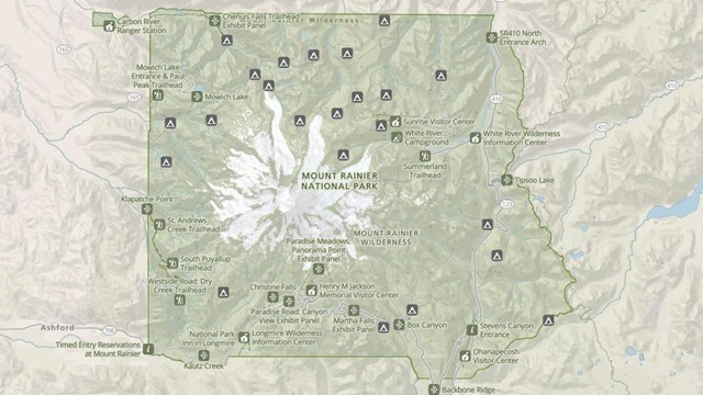
Park Maps
Maps of Mount Rainier National Park, including the Wilderness Trip Planner Map and area trail maps. |
Last updated: February 18, 2025