
NPS Photo
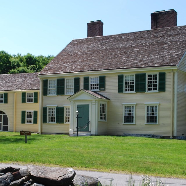
Brooks Hill OverviewBrooks Hill is a rise of ground located roughly one mile Southeast from the intersection of Meriam’s Corner in Concord Massachusetts. Today, the Battle Road Trail, and Historic Bay Road (Rt. 2A) run east-west over Brooks Hill. Although the summit of Brooks Hill peaks just over 600 yards south of the Bay Road, the area along the road itself is an elevated plateau starting approximately 1,500 yards Southeast of Meriam’s Corner. The Brooks Hill Plateau (Also known as Brooks Village) stretches eastward for roughly 660 yards before descending steeply to the waters of Elm Brook and the base of the next hill known as Elm Brook Hill. On the western edge of Brooks Hill a narrow country lane called Brooks Road intersects the Bay Road and runs directly south toward the town of Lincoln. Human inhabitation of this region dates back twelve thousand years before the arrival of European Colonizers. For nearly one thousand years, Algonquain peoples thrived along the Musketequid River before the creation of Concord Plantation. Those peoples likely hunted large game in the forests that once covered the area now known as Brooks Hill. With the establishment of Concord Plantation in the mid-17th Century, Europeans laid a colonial road over existing indigenous footpaths stretching inland toward the coast. This colonial road, known as the Bay Road, played a prominent role in the widespread colonization of land between Concord and Boston. By 1775 a cluster of colonial homes from the Brooks family lined the Bay Road along the broad rise of land referred to as the Brooks Hill. In this area, the Brooks family operated several farms and a tannery at elm brook on the eastern edge of the hill. 
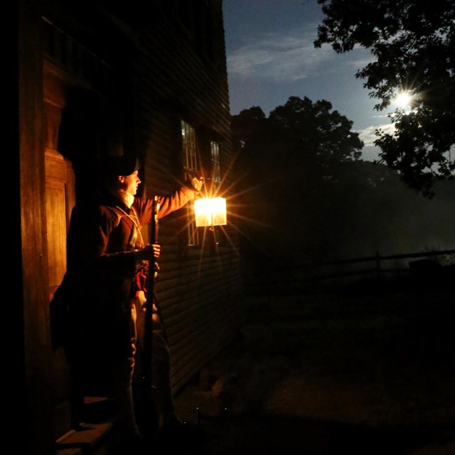
NPS Photo The Road to WarIn the early morning hours of April 19, 1775 alarm riders spread word through Brooks village about an expedition of 800 British soldiers marching from Boston to Concord. The alarm riders warned that the British army intended to search the town for colonial munitions and possibly arrest local Patriot leaders. Within hours most towns across Massachusetts mobilized companies of Militia and began marching toward Concord. Coming from a variety of different locations, those militia companies traversed numerous winding roads leading to confrontation. For the British Army, the route to Concord lay on the well-known Bay Road. By 8 A.M. the lead elements of the British column marched up and over Brooks Hill, before descending into the planes of Concord. Once in town, the British soldiers sent detachments to search for military supplies but ultimately found very few munitions. At Concord’s North Bridge, tensions between gathering militia and the British soldiers guarding the bridge devolved into bloodshed in a moment termed “The Shot Heard Round The World.” In just seconds, five men lay dead with nearly twenty more wounded. This short engagement set the tone for the British escape from Concord later that afternoon. The Battle of the Bay RoadNear 12:00 p.m. the British expedition formed into column and began their long retreat of eighteen miles back to Boston. As the British army exited Concord on the Bay road, their column stretched nearly 1/3rd of a mile in length and featured advance, rear, and flank guards stationed at 100 yards distance for protection. As the British column marched out of Concord, thousands of Colonial militia soldiers poured into the area surrounding the Bay Road. Atop the Brooks Hill plateau, the important convergence of Brooks road and the Bay Road led multiple militia companies into position on high ground overlooking the British exit from Concord. The first militia companies to arrive at Brooks Hill consisted of 180 men from the town of Woburn, marching by way of the Lincoln meeting house. Earlier that morning, those Woburn companies arrived at Lexington Green, minutes after the massacre of Capt. Parker’s militia company by the British column. According to Major Loammi Baldwin, the Woburn men, “…heard a great firing; proceeding on, soon heard that the Regulars had fired upon Lexington people and killed a large number of them. We proceeded on as fast as possible and came to Lexington and saw about 8 or 10 dead and numbers wounded.” After helping care for the dead and dying the Woburn men marched west in pursuit of the British soldiers. With an abundance of caution the militia circumnavigate the Bay Road to avoid a dangerous confrontation with the British column marching toward Concord. By noon, the Woburn men arrived on the high plateau near Brooks village where they stopped to pitch and refresh themselves. During this time, Major Baldwin rested at one of the Brooks family homes, while some of his soldiers posted themselves to view the Bay road leading out of Concord nearly a mile away. Before long, Major Baldwin reported, “The people under my command and also some others came running off the East side of [Brooks] hill…” with news of the British retreat. Alerted to the approach of the British column, Baldwin decided to withdrawal his command to a better position farther east on Elm Brook Hill. Although the exact timing of Baldwin’s movement is unknown, his failure to mention gunfire coming from Meriam’s corner may indicate the Woburn companies began moving before hostilities commenced along the Bay Road. While the Woburn militia companies retired further east from Brooks Hill, hundreds of additional Colonial militia arrived near Meriam’s corner on the flanks and rear of the British column. For the next half-mile leading from Meriam’s Corner to the high ground on Brook’s Hill the British soldiers marched along an elevated portion of the Bay road. British offices could see hundreds of Colonial militia moving into position in the fields on the north side of the road and across the high ground at Brooks Hill to their front. After moving about 1/3rd of a mile from the edge of Concord, the crackle of gunfire at Meriam’s corner suddenly cut the tension. In an instant the road from Meriam’s corner to the base of Brooks Hill became a gauntlet of gunfire. As multiple militia companies poured musketry into the British rear guard at Meriam’s corner the head of the British column pushed forward. Along this stretch of the road, British officer Lt. John Barker recalled, “…before we had gone half a mile we were fired on from all sides, but mostly from the rear, where people had hid themselves in houses, ‘till we had passed and then fired…’” Another British officer, Lt. William Sutherland of the 38th Regiment of Foot also recalled, “…just at the end of the town next to this a few concealed villains fired on us, of which we killed 2, but they wounded 2 of ours.” After receiving a wound at the North Bridge, Southerland likely road in a carriage somewhere near the middle or front of the British Column now approaching the base of Brooks Hill. Ascending Brooks Hill
NPS Photo As gunfire echoed from the low ground to the west, new companies of Militia arrived on the battlefield at the intersection of Brooks road and the Bay road on the western rise of the hill. Two companies of Minute men and Militia from East-Sudbury arrived in time to meet the British column. While marching nearly eight miles on the morning of April 19, 1775, the soldiers of Captain Nathaniel Cudworth’s minute company and Captain Joseph Smith’s militia company likely received reports from a second wave of alarm riders that directed them toward the battlefield. 
NPS Photo Although the exact location of the engagement on Brooks Hill remains unknown, the arrival of Sudbury Militia on the southern side of the Bay road near the intersection of Brooks Road indicates the fighting began as the British regulars ascended the first rise of ground. One local historian later wrote the fight was, “…a spirted affair, where one of the Sudbury companies, Captain Cudworth, came up and vigorously attacked the enemy.” With less than a hundred men available to engage the lead elements of the British column, it is likely the Sudbury attack became a quick moving engagement spreading across the Brooks plateau. For the rear of the British column, the route from Meriam’s Corner to Brooks Hill foreshadowed the grueling fight to come. With more militia companies arriving by the moment, the pursuing militia pressed the British rearguard and poured a hail of continues gunfire into the British ranks. When the British rear guard ascended Brooks Hill, some colonial militia broke their pursuit and cut across the low open fields on the northern side of the road to find another position near Elm Brook Hill a mile east. Meanwhile, companies of Chelmsford militia pressed an attack on the British rear guard now crossing over the Brooks Hill plateau. Years after the battle, the Grandson of a Chelmsford soldier related his grandfather’s story, “We reached Concord in time to have a part in the pursuit of the retreating redcoats. We had our first shot at them at Meriam’s Corner, and more at Hardy’s [Brook’s] Hill. Captain Ford, who was at this time sergeant in Captain Barron’s company, was prominent on the Hill. He was an old fighter of the French and Indians, and knew how to handle his musket to an advantage. He claimed to have caused the death of five of the enemy on Lincoln soil.”

NPS Photo As the spirited engagement raged across the high plateau of Brooks Hill the front of the British column soon descended off the eastern rise and into the valley at Elm Brook. After crossing over a small Bridge the British regulars ascended another steep slope to a sharp bend in the Bay Road where multiple companies of Woburn Militia waited to deliver a devastating volley of musketry at close range. Although the fighting at Brooks Hill rolled quickly from one slope to the other, the confluence of Brooks Road offered a valuable egress for arriving Militia units to join the fight and delayed the British column long enough for colonial militia to lay a deadly trap at the “S” bend in the Bay road atop Elm Brook Hill. Continue The Story: |
Last updated: December 1, 2021