
NPS photo Snow travel at Lassen Volcanic National Park requires entering avalanche terrain. Each year, avalanches claim more than 150 lives worldwide. Knowledge, information, and equipment are key to preventing and surviving avalanche accidents. Before you enter the winter wilderness, ensure that you have a solid understanding of avalanche awareness and carry avalanche/rescue equipment. Avalanche ForecastsThere is no avalanche forecast for Lassen Volcanic National Park or the general Lassen area. Backcountry users are encouraged to use the park weather forecast, snow station measurements, and their own observations to evaluate risk.
Plan Your RouteThe Southwest Area of Lassen Volcanic contains steep terrain with numerous hazards. The Southwest Avalanche Hazard Map below highlights avalanche-prone slopes and other hazards including hydrothermal features and rockfall areas. The following actions can help improve your safety in the backcountry:
Avalanche Safety GearSnow ShovelThis is essential for testing snow conditions and quickly digging out victims. A snow shovel is also a critical tool for making snow shelters. Most have detachable or telescoping handles for easy packing. Aluminum blades are light yet strong. ProbeThis collapsible pole—similar to a tent pole—can be used to probe for buried avalanche victims by itself or during the pinpoint search with an avalanche transceiver. They are usually made of aluminum or carbon fiber for low weight and above-average strength. Avalanche Transceiver (Beacon)Worn on the body, this device emits a pulsed radio signal. If a person gets buried in an avalanche, other transceivers carried by the party pick up the signal emitted from under the snow. The device can only be located it if it is turned on and in transmit mode. Beacon Check 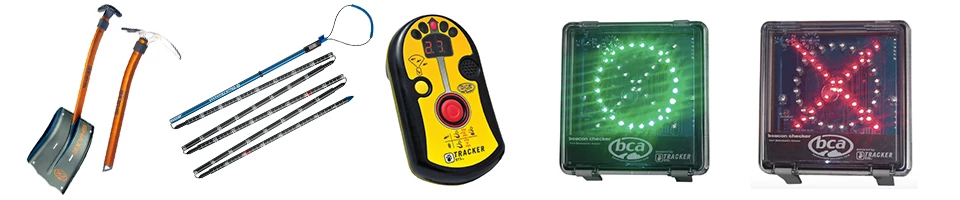
Backcountry Access (BCA) Be Avalanche AwareRecognize Red Flags
Identify Avalanche TerrainSlope AngleAvalanches are possible on any slope steeper than 30 degrees and as steep as 50 degrees. They occur most frequently on slopes 35 to 45 degrees. Avalanches may also occur on slopes of less than 30 degrees that are exposed to steeper terrain above. AspectWhich way does the slop face in relation to sun or wind? Cornices indicate prevailing wind direction and may be a sign the slope is being windloaded. Does the slope face the sun or is it in the shade? Common Trigger PointsAvalanches may be triggered from flatter areas in the runout zone or along ridge crests. Watch for wind deposited snow; breakover or mid-slope steepening; areas ner rock outcrops; or shallow areas in the snowpack. Terrain TrapsWatch for anything that increases the consequences of being caught in a slide, like cliffs, trees, and rocks. A flat transition or a gully means a deeper burial. Frequent Avalanche Terrain
Avalanche Terrain MapFormal Avalanche TrainingSome days are dangerous and some days are not. Learning about avalanches will help you decide when, where, and how to visit the backcountry. Even expert backcountry users refresh their avalanche training regularly to improve their safety. Free Introductory Training
Find a Paid CourseAvalanche.org lists Access American Avalanche Association-endorsed course providers by state. Only a few course are offered in Lassen Volcanic National Park each year. Courses are more commonly available in the nearby Mount Shasta area and Lake Tahoe area, which includes Truckee, Donner Pass, and South Lake Tahoe. Related Links
|


Last updated: November 25, 2024