Snowpack

A compilation of three images showing 15+ foot high walls of snow
Snowpack along the park highway from 1933 (left) to recent years.
 

Although both seasonal and fleeting, snowpack is a valuable natural resource. The snow at Lassen Volcanic provides superb winter recreation and creates a winter habitat to which park animals and plants are well-adapted.

Melted water from snow, ice, and ground springs at Lassen slowly release water that replenishes rivers, reservoirs, and aquifers in the California's dry, summer months. Water from Lassen flows through four watersheds that provide the state with water for drinking, irrigation, domestic usage, and hydroelectric energy production. Rapid changes in climate over the last few decades have resulted in reduced snowpack, warmer wintertime temperatures, and earlier spring melt, which deplete these crucial snow-based reservoirs.


Lassen Peak Snowpack Measurements

Park staff began collecting measurements at the Lower Lassen Peak (LLP) snow course in 1930. Today, more than 50 state, national, and private agencies pool their efforts in collecting snow data throughout California. Visitors to the Lake Helen picnic area (8,250 feet elevation) may have spotted the 36-foot-tall snow sensor that collects and transmits real-time data to specialists at the California Department of Water Resources. Data from the Lower Lassen Peak remote station is manually verified four times each winter by a surveyor. View LLP sensor measurements (hourly/daily) or manual measurements (January - April) including manual measurement history since 1930.

2024 Lower Lassen Peak Manual Measurements

Month Depth
(inches)
% of Monthly Average Water Content (inches) % of Apr. 1st W.C Average Density
Jan N/A
Feb 96 N/A 38 48% 38%
Mar
Apr
May

LLP Measurement Records

There are three main measurements for snowpack: depth and density, which combined determine snow water content equivalent. At Lassen, the records for each of these individual measurements occurred in April of different years.

  • 1983 - deepest snowpack: 331 inches (27.6 feet)
  • 2017 - highest water density: 55%
  • 1995 - highest snow water content equivalent: 145 inches (12.1 feet)

The highest snow water content reflects the largest amount of water to result from snowmelt in the park in 1995, when the snowpack was both deep (287 inches/23.9 feet) and dense (51%).

 
A graphic depicting snow depth records
The deepest snowpack, highest water content equivalent, and highest density at Lassen occurred in different years.
 

How Much Water is in Snow?

Not all snow is equal when it comes to water content. Snow is composed of frozen water crystals, but because there is so much air surrounding each of those tiny crystals in the snowpack, most of the total volume of a snow layer is made up of air.

Snow water equivalent of snow is the thickness of water that would result from melting a given layer of snow. In April of 2017, Lassen's snowpack was 55% water. More than half of the 253 inches of snow on Lassen Peak was water. If all that snow melted instantaneously, it would create a pool of water 134 inches (11 feet) deep.

 
Text and images describing activity for measuring water content in snow
 

Forecasting Water from Snow

Data from the Lower Lassen Peak (LLP) snow measurement site is used to produce monthly forecasts from January to May. Forecasters use average density and depth for each snowpack to estimate spring and summer snowmelt runoff into rivers and reservoirs. Measurements taken on or around April 1 at established sites are generally the most significant as this is when the snowpack is normally at its greatest depth and density.

Snow water equivalent forecasts provide valuable information for recreation, agriculture, flood management, and hydroelectric power generation. Companies, like Pacific Gas and Electric Company (PG&E) in northern California, use the forecasts to determine what percentage of their electric energy generation will be hydro power. Water storage managers determine how much water can be safely stored in a reservoir while reserving space for predicted inflows, like snowmelt and rainfall.

Learn more about the manual measurement process at LLP.

 
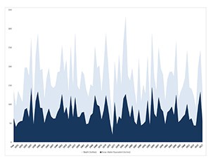
Graph of snow depth and density over time
Snowpack depth (light blue) and snow water equivalent (dark blue) in inches by year since the measurement began in 1931 at the Lower Lassen Peak site near Lake Helen.

Lassen's Snowpack over Time

California Department of Water Resources has been recording snowpack measurements at Lower Lassen Peak since 1930. Data shows normal variations in snowpack over time. However, rapid changes in climate over the last few decades have resulted in warmer and drier conditions overall. Reduced snowpack leads to reductions in melted snow that is available to the state's water supply.

Even with normal snowpack depth and density, warmer spring temperatures can result in earlier spring melt. This early melting can stress the capacities of man-made reservoirs that are designed to store and gradually release water during California's long, dry summers.

Learn more about the effects of climate change and drought in the park.

Last updated: January 31, 2024

Park footer

Contact Info

Mailing Address:

PO Box 100
Mineral, CA 96063

Phone:

530 595-4480

Contact Us