|
Backpackers on the Trail Creek route traverse a gentle glacier and navigate across alpine tundra. Details to help you plan your trip are below. With four million undeveloped, wild acres to explore there are countless places go for adventure, solitude, and recreation in Lake Clark. Part of the purpose of the park is to allow for individual, personal exploration of wilderness; therefore, the only maintained trails are the Tanalian Trails near Port Alsworth. This page only describes the general terrain in the high country between Telaquana and Turquoise Lakes; it does not describe in detail the exact route you should walk. Instead, we encourage you to use the information provided to plan your own unique trip. This off-trail route can be expanded, linked with other routes, or simply used to get an idea of the terrain. Adventurers in Lake Clark will need to rely upon way-finding, map-reading, and trailless hiking skills to navigate, or hire a guide who can help. 
Photo by A. Lindholm MapsUSGS 1:63 360 Series Topographic Map Lake Clark C3 & D3 & D2 AccessFly in to Telaquana Lake. Fly out from Turquoise Lake. A float or amphibious plane is required in order to land on these lakes in the summer, as neither have beaches suitable for a wheeled plane to land. Planes operating on wheels or skis may land on either lake in the winter if ice conditions are suitable. Time3-5 days. DifficultyModerate trail-less hiking over rolling alpine tundra, steep rocky passes, and glacier travel. HighlightsSpectacular mountain scenery, opportunities for adventure and solitude. HazardsPotential river crossings. Glacier travel required. Bears. RouteBegin along the south shore of Telaquana Lake and head south to the Trail creek drainage. Trail creek is alpine country that turns into rocky glacial moraine. Watch out for loose boulders as you climb up the steep rocky pass and descend down the steeper and rockier north side of the pass. You'll emerge onto a wide glacier that is one of the most gentle glaciers in the park. If you follow the glacier downhill, then walk along the river that emerges from it, you will end up at Turquoise Lake. This route may be modified by reversing the direction of travel, or continuing on to Twin Lakes. Campsites and Food StorageFood and toiletry items must be stored in approved bear resistant canisters if camping within 1/2 mile of Telaquana, Turquoise, or Twin Lakes. Bear resistant canisters are highly recommended on this trip even if you plan on camping away from the lakes due to the lack of suitable trees to hang food. Canisters can be rented for free at the park visitor center in Port Alsworth. You should also cook at least 100 yards away from your camp to avoid an association made by bears between your camp and your food. Set up camp away from bear trails and feeding areas, including salmon-bearing stream banks. Please follow leave no trace ethics and park rules and regulations when choosing campsites, storing food, and building campfires. 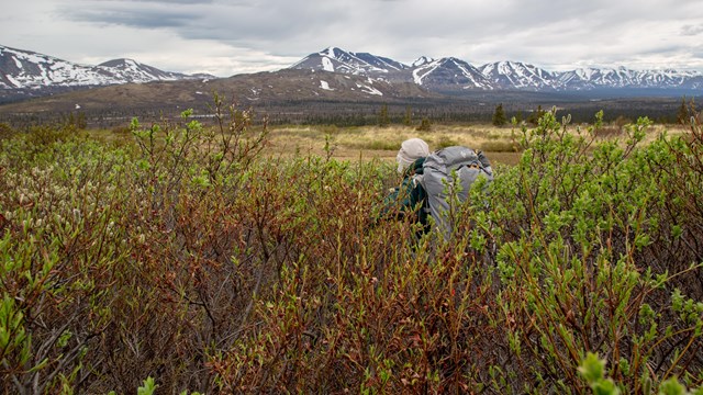
Backpacking in Alaska
Get acquainted with what makes backpacking in Alaska unique and familiarize yourself with these backcountry tips before you plan your trip. 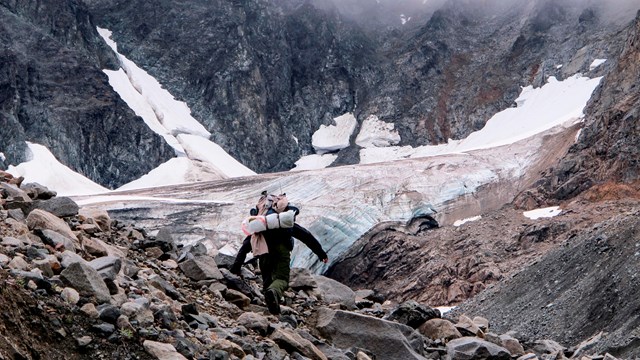
Trail Creek Route Photos
Images taken along the Trail Creek Route. |
Last updated: July 30, 2019