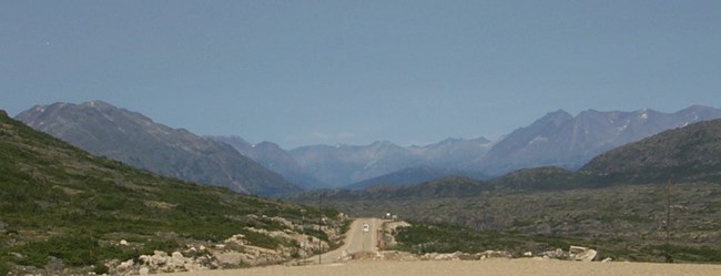
Skagway is known for its gold rush history, but its natural history tells a fascinating story of its own, some of which can be seen from the boardwalks as you explore town. Understanding the forces that shaped the land here brings the breathtaking scenery alive.
This guide provides background information on the geologic forces which created the land, the glaciers that shaped it, and the gold that made it famous. The final section is a road guide- use it while driving up the first 18 miles of the Klondike Highway to see examples of the features described in this brochure.
As you travel throughout Southeast Alaska, keep an eye out for features similar to those described here. Enjoy your visit to Skagway!
Over millions of years, many forces have acted to shape the modern Skagway River Valley. The origin of the local landforms, as well as the origin of Klondike gold, began deep within the Earth. The formation of these landscapes can be explained by geologic principles.
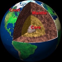
Three layers make up the Earth’s interior. At its center is the core, which has a solid inside and a liquid outside. Surrounding the core is a layer of very hot, but solid, rock called the mantle. Over the course of millions of years, the hot rock of the mantle can flow very slowly, creating convection currents similar to the ones you might see in a pot of boiling water. The mantle is Earth’s thickest layer and accounts for 84% of the Earth’s total volume. On top of the mantle lies the cold and brittle crust, which makes up the earth’s land surfaces and ocean floors. The crust is very thin relative to the core and the mantle. The crust beneath continents is much thicker and buoyant than the crust of the ocean floors, which is thin and dense in comparison.
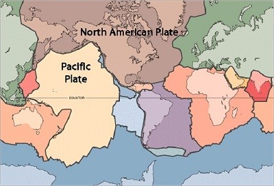
There are 15 major tectonic plates worldwide. Southeast Alaska sits at the juncture of the Pacific Plate to the west and the North American Plate to the east. The flow of mantle below these plates forces them to collide, spread apart, and slide past each other. These interactions between plates are responsible for the formation of mountain ranges, volcanoes, and earthquakes. 
The collision of these two plates has resulted in three major types of geologic events: uplift, faulting, and magma injections.
Uplift
The crumpling of the North American Plate where it strikes the Pacific Plate is causing the relatively smooth surface of the crust to buckle and rise, similar to the hood of a car involved in a front-end impact. The land is lifting up to form mountains. The Coast Mountains surrounding the Inside Passage and Skagway are the result of this uplift.
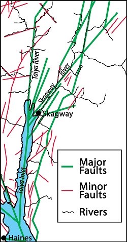
Just as the hood of a car forms dents and cracks under impact, the solid crust fractures under the pressure of oceanic-continental convergence. Fractures along which movement or slippage takes place in otherwise solid bedrock are called faults.
In this area, the Pacific Plate is not only traveling towards the North American Plate, it is also rotating counterclockwise. Where the plates come into contact there are many faults that radiate out in different directions as they slowly move against each other. Energy from the plates' movement spreads out among all the fault lines instead of concentrating in one. As a result, Skagway frequently experiences earthquakes that are too small to feel.
It's common for rivers to find these lines of weakness because these lines offer the path of least resistance. Some of the region's many faults lie below the Skagway and Taiya River Valleys.
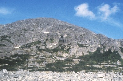
The underside of the North American Plate is also impacted by oceanic-continental convergence. Fractures beneath the surface are commonly filled and expanded by intruding magma. Trapped within solid crust, these magma chambers cool slowly until hard, becoming huge bodies of granite called plutons. Uplift raises these plutons. Millions of years of weathering and erosion eat away at the miles of material on top of the plutons, eventually exposing them as the massive granite mountains around Skagway.
Geology, Glaciers, and Gold sections
Photographs and figures were provided by National Park Service rangers B. Aulick, P. Cooper, M. Hachtmann, S. Hinderman, and S.Millard; the National Archives, This Dynamic Earth by Jacqueline Kious and Robert Tilling, Earth's Interior and Plate Tectonics by Calvin and Rosanna Hamilton, the Alaska State Library Alaska Purchase Centennial Collection, Melanie Moreno and the United States Geological Survey. |
Last updated: January 12, 2018
