
Gullah/Geechee Cultural Resource Mapping Project

A unique African-American culture developed and flourished along the Atlantic coast and the Sea Islands of the southeastern United States as enslaved West African populations survived in isolated environments, such as the rice plantations which made the coastal region famous. Due to their isolation during the 17th-19th centuries, the population, known as Gullah in the Carolinas and Geechee in the Georgia, and their descendents, were able to develop distinctive speech, styles of dress, and architecture, in addition to self-sufficient farming and fishing traditions that distinguished them from other groups in the region.
Mapping Cultural Resources
With the expansion of modern resorts, gated communities, and golf courses, the Gullah/Geechee culture as a viable living community is now under siege. The unique elements of their traditional cultural properties are being subverted or destroyed by modern development and the threat of climate change. Recognizing the importance of this culture to the history of the United States and the need to help protect it, Congress designated the Gullah/Geechee Cultural Heritage Corridor in 2006. The Heritage Corridor runs along the coastline roughly from Wilmington, North Carolina to St. Augustine, Florida, extending 30 miles inland from the coast.
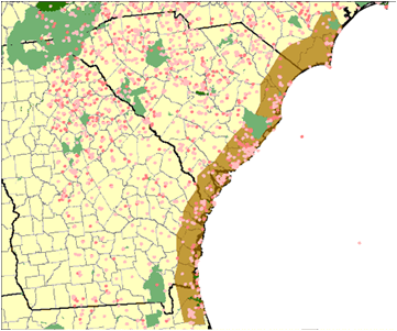
The National Park Service, Cultural Resource GIS Facility (CRGIS) is working with a task force from the Gullah/Geechee Cultural Heritage Corridor to establish a GIS database to house the inventory of the 890 currently identified sites. The first component of the project involves assessing the level of documentation associated with these sites using transcripts of public meetings, the National Register of Historic Places, and State Historic Preservation Office (SHPO) inventories. This information will give the Corridor a starting point in determining which resources already have some level of protection and which ones need further research. The second component consists of locating these resources within the Cultural Heritage Corridor using the Geographical Names Information System (GNIS), Google Earth, the National Register of Historic Places, as well as information provided by SHPO nominations and staff. Using GIS, the Cultural Heritage Corridor staff will be able to effectively monitor and help mitigate resort development, tourist trade impacts, and other long term forces such as climate change.

