|
A ruin is usually described as a building or structure that is no longer habitable or functioning according to its original intentions. Most of the records associated with documenting and maintaining ruins become part of the museum collection as Resource Management Program archives. The National Park Service mission is to “preserve unimpaired the natural and cultural resources and values of the national park system for the enjoyment, education, and inspiration of this and future generations.” Ruin preservation activities may be seen throughout the park as we conduct work to maintain the structures and landscapes of this national treasure.
The majority of our featured ruins are documented via the Heritage Documentation Programs, which is part of the National Park Service. It administers the Historic American Buildings Survey (HABS), the Federal Government's oldest preservation program, and its companion programs: the Historic American Engineering Record (HAER) and the Historic American Landscapes Survey (HALS). Documentation produced through HABS/HAER/HALS constitutes the nation's largest archive of historic architectural, engineering, and landscape documentation. Learn more on the Heritage Documentation Programs website.
#1: Potomac Power Plant, U.S. Armory Archeological Site 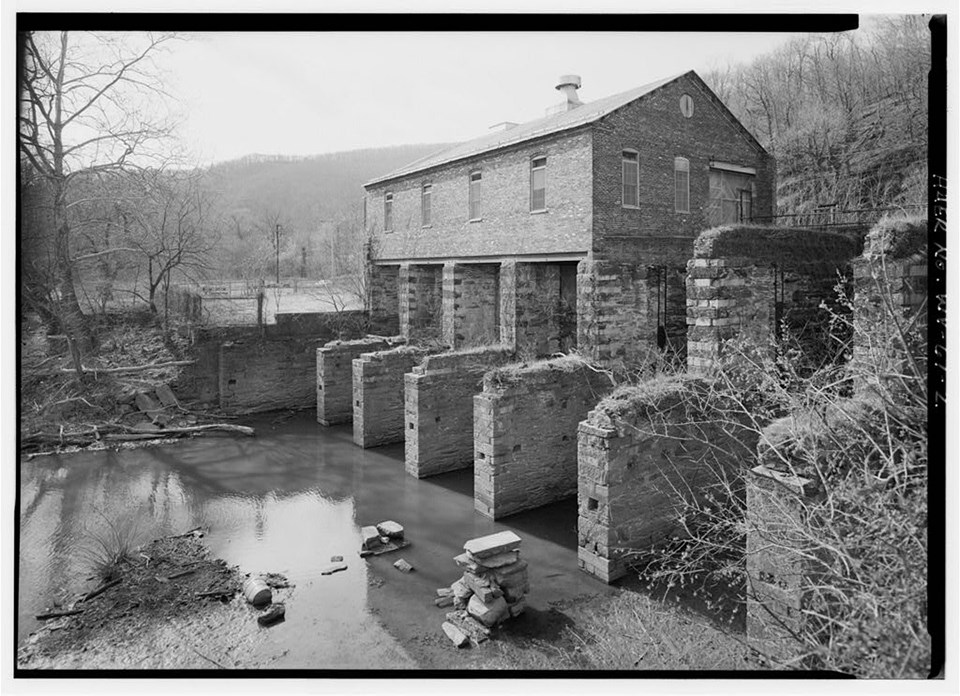
Jet Lowe, HAER Photographer Location: On the West Virginia shore of the Potomac River about one mile upriver from the confluence with the Shenandoah River, at the end of Potomac Street. Date of Construction: 1888, partially rebuilt and reconfigured 1925. Original Owner: Thomas Savery The Potomac Power Plant was an innovative small hydroelectric facility that operated from 1899 to 1991, originally as part of a wood pulp mill (built 1888), and solely as a power house after a fire in 1925. Significant extant equipment/machinery in the plant includes a c.1905 Dayton Globe water turbine, and a 1925 Woodward water turbine governor. The building is also symbolic of industry in Harpers Ferry, as it occupies the site (and possibly the partial foundations) of Harpers Ferry Armory buildings dating to 1834 and 1853, and contains reused structural materials from various Armory buildings as well as from the 1848 Harpers Ferry cotton mill (later a flour mill). Catalog Number: Library of Congress, HAER No.WV-61, 1998 #2: Harper House, Public Way 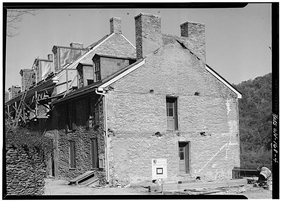
Harold A. Nelson, October 1958 The Harper House was built by Robert Harper, who was the founder of Harpers Ferry. It’s the oldest surviving building in town. Today, visitors can see an amazing view of the river confluence from the upper porch. Harper began to construct this stone dwelling in 1775, yet he died before it was finished in 1782. From 1782 until 1803, the Harper House was the town’s only tavern, and it’s depicted as a landmark in early town photos and maps. When the National Park Service began major restoration work in the 1950s, the Harper House was considered a priority. The building’s architectural features were recorded in one of the first Historic American Building Surveys in Harpers Ferry. Catalog Number: HABS WVA,19-HARF,10--4, Perspective view of West and South side. #3: St. John’s Episcopal Church Ruins, Church St. 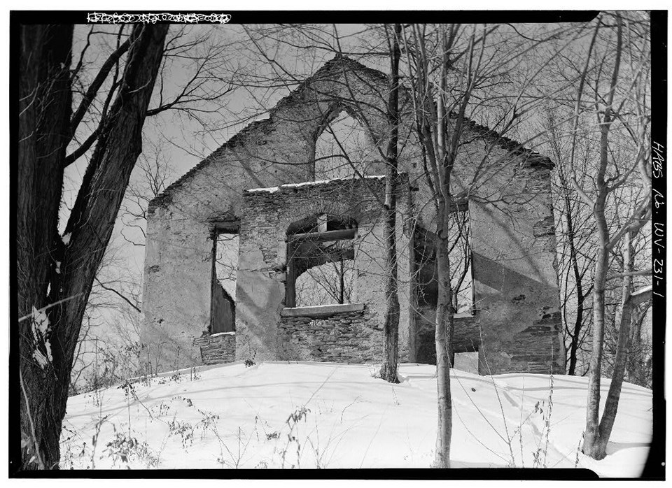
Jack E. Boucher, January 1961. These weathered ruins are all that remain of St. John's Protestant Episcopal Church - one of Harpers Ferry's five earliest churches. Built in 1851-1852 with money provided by church fairs, St. John's served as a hospital and barracks during the Civil War and suffered considerable damage. It was rebuilt afterward, but was abandoned in 1895 when a new Episcopal church was built in the upper town. Today, the National Park Service preserves the ruins by stabilizing the historic field stone walls, which were once completely faced with mortar. Managing the trails around the site so that visitors are discouraged from climbing the fragile ruins is also part of the preservation plan. #4: Smith and Forging Shop, U.S. Armory (Musket Factory) 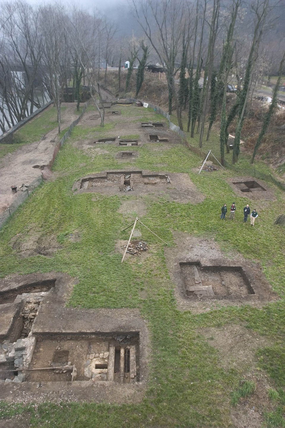
Photo by Robert E. Brzostowski Beneath your feet in the U.S. Armory (Musket Factory) Grounds, sits the ruins of the Smith and Forging Shop. Built to replace the first Armory gunsmith forging shops, it was completed in 1848 and was connected to the Inspector’s office. When completed, the combination Smith and Forging Shop, with overall dimensions of 280 ft. by 36 ft., was the largest workshop ever erected at the armory. This image shows only one wing of the building, and some of the archeologists are in the image for scale. Two field seasons of excavation at the Musket Factory site revealed that the Smith and Forging Shop central forge venting system was in tact in the center of the wing. Machinery parts, and brick herringbone flooring was also found in tact. These discoveries are exceptional, considering the high amount of destruction and salvaging of the U.S. Armory site during the Civil War and afterwards. A brief history of the Armory begins in 1794, when Congress approved a bill "for the erecting and repairing of Arsenals and Magazines." Springfield, MA, was chosen as the site for the first national armory. President George Washington, given wide discretionary powers in executing the legislation, then selected Harpers Ferry for a second national armory. In 1796, the government purchased a 125-acre parcel of land bounded by the Potomac and Shenandoah rivers from the heirs or Robert Harper. Construction of the "United States Armory and Arsenal at Harpers Ferry" began in 1799. Three years later full-scale production of arms commenced. Muskets, rifles and, after 1805, pistols were all manufactured here. By 1810, annual production of arms averaged about 10,000. For further in-depth information, consult these park studies: Catalog Number: Harpers Ferry National Historical Park Resource Management Archives, Accession HAFE-1344, 2007. #5: Shenandoah Pulp Mill, Shenandoah St. 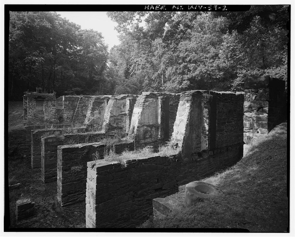
John Nicely, June 23, 1994. The potential for water-powered industry was recognized early in Harpers Ferry's history as illustrated by the establishment of the National Armory in 1798. The Shenandoah Pulp Mill, built in 1887-88 by Thomas Savery, was the last water-powered mill to operate on Virginius Island. Built on the site of the Shenandoah Canal's lower lock, the mill ground wood to pulp for the production of paper. Flumes channeled water over five pairs of turbines, which powered the pulp-making machinery. Three pairs of the turbines were New American Water Wheels on horizontal shafts, one pair was New American Water Wheels on vertical shafts and one pair was Improved Success Water Wheels on vertical shafts. By the 1920s, the mill was producing 15 tons of wood pulp daily. Mounting losses forced the pulp mill to close after 45 years of of operation in 1935. Most of the structure was swept away in the flood of 1936, leaving only the massive stone piers. The closing of the Shenandoah Pulp Mill marked the end of the water-powered industrial era on Virginius Island. However, the stone foundation remains as an important artifact of hydraulic technology in the development of the Potomac River Valley. Catalog Number: Library of Congress, WV-59-2 View Southwest, North and East of Walls 1, 2, 3, 4, 5, 6. #6: Stone Fort, Maryland Heights 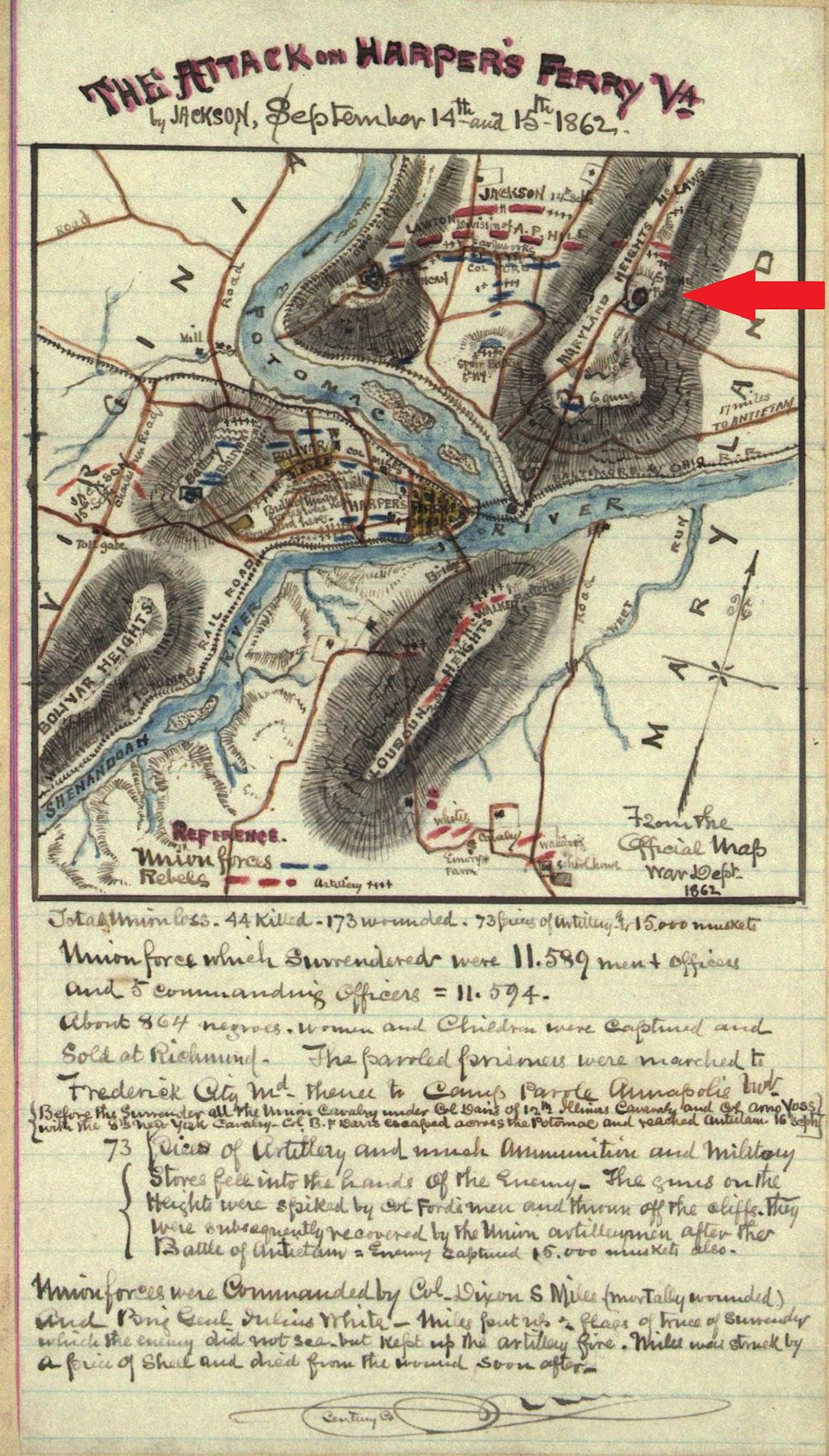
Map made by Robert Knox Sneden in 1862 At the highest point on Maryland Heights (1,448 ft), stands the Stone Fort- the largest stone Civil War structure in the park. Union engineers originally designed this fortification as an infantry blockhouse. Though the date of construction is unknown, final plans were approved on October 20, 1862. The fort was never completed, and by Sept. 1863, it served as a commissary and storage area. This map shows the area of convergence of the Potomac and Shenandoah rivers that marks the border of Maryland, Virginia, and West Virginia. Details include the location of Union forces in the town of Harpers Ferry and Confederate forces on Maryland Heights across the Potomac. Map Maker: Sneden, Robert Knox, 1832-1918. Credit: Sneden, R. K. (1862) The attack on Harper's Ferry Va., by Jackson, September 14th and 15th, 1862. [to 1865] [Map] Retrieved from the Library of Congress, "From the Official Map, War Dept., 1862."--page caption. Note: red arrow added by NPS staff. #7: Small Arsenal, Arsenal Square 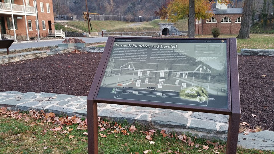
NPS Photo/Hammer The small arsenal building stood from 1806-1861, and it was one of two warehouses that stored firearms manufactured at the nearby United States Armory manufactory. In 1859 abolitionist John Brown attacked Harpers Ferry hoping to inspire a revolt against slavery. Brown wanted the arsenal's weapons to arm recruits. When the Civil War began in 1861, retreating U.S. troops burned both federal arsenal buildings to keep the weapons from falling into Confederate hands. In 1959, National Park Service archeologists first excavated the foundation. The wayside in this picture shows the archeologist’s excavation drawings that exhibit how a 1870s building was built over the remains of the Small Arsenal. The walls that are visible today are interpretive foundations that were constructed by historic preservation specialists, including stonemasons. These modern walls were built about two feet above the original foundation walls, in order to preserve the original ruins. #8: Wager House/Marmion Hall, Public Way 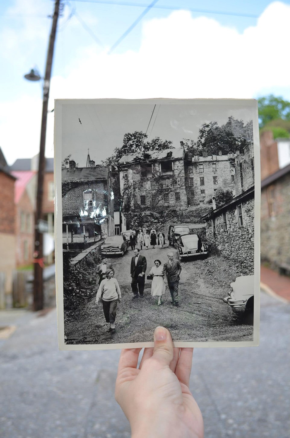
Modern “Then and Now” - NPS Photo/Farmer In 1958 historical architect Archie Franzen dubbed the Wager House, a.k.a. Marmion Hall as “architecturally the most pretentious house in the park.” It was constructed circa 1832-1834 by James B. Wager to be the main dwelling of his family, who were among the wealthiest local citizens. The beloved local doctor, Nicholas Marmion, bought and renamed it “Marmion Hall” in 1847. The home witnessed the ravages of the Civil War, and it was one of the few structures that was not abandoned. The Marmion family stayed and endured the War as they came under fire from both sides. When the National Park Service acquired the Marmion property, it was in a ruinous state. Along with the attached Harper House, it became an early park reconstruction priority. In this 1955 image, the Wager/Marmion Hall and the edge of Harper House (far left) are visible on the hill. Harpers Ferry National Monument was in its infancy (est.1944), and many of the structures were not yet preserved. The historic image was taken at the end of Hog Alley, during a "special tour" on May 22nd, 1955, and we’re holding it in the modern streetscape to show a “then and now” view. To learn more about the development of the Monument into a National Historical Park, check out our administrative history (12.8MB pdf).
#9: The Cotton/Flour Mill, Virginius Island 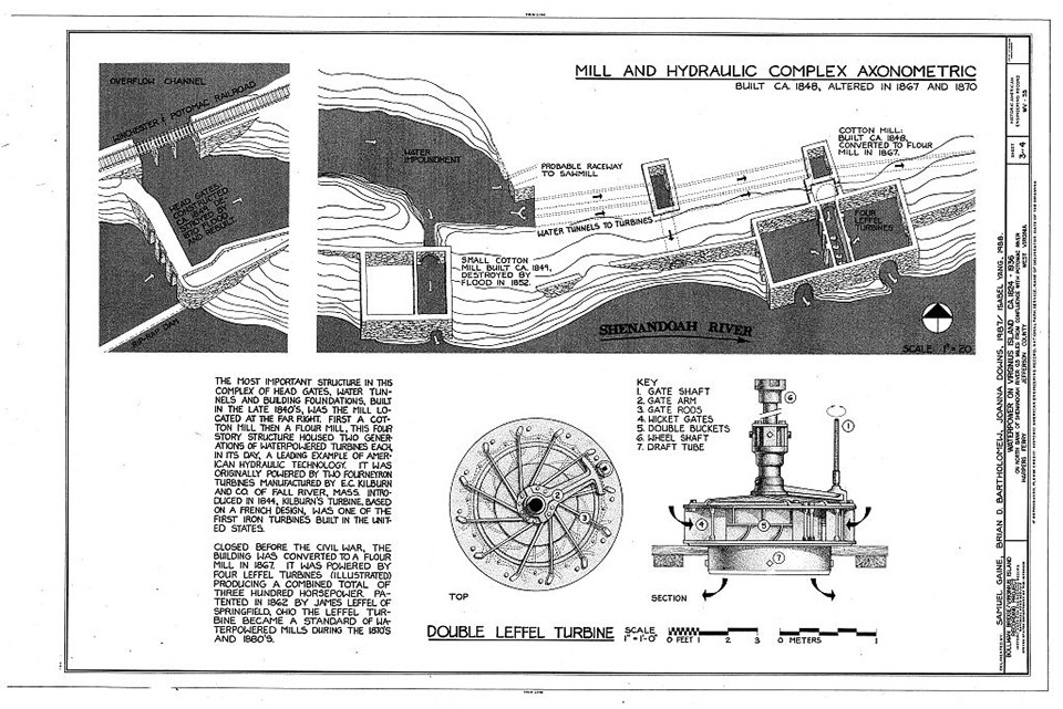
Drawings from Survey HAER WV-35. In 1848, a four-story “Brick Factory Building, of the most permanent character,” began operation here. The building was fitted with gas lights, heated by steam with pipes, and equipped with the latest cotton machinery. During the Civil War, the building served as a Union hospital. After the war, it was converted into a flour mill and four innovative Leffel Company iron turbines were installed. These turbines remain in the building today. The building was abandoned after the Flood of 1889. The site is continually submerged in the Shenandoah River as water levels change. The NPS preserves the ruins in part by periodically removing invasive plants that may damage the foundations, and by using materials such as hydraulic cement (withstands water). Catalog Number: Library of Congress, HAER WVA,19-HARF,29- (sheet 3 of 4) Drawing Description: Waterpower on Virginius Island, Shenandoah River near Potomac River, Harpers Ferry, Jefferson County, WV Drawings from Survey HAER WV-35. #10: John H. Allstadt House 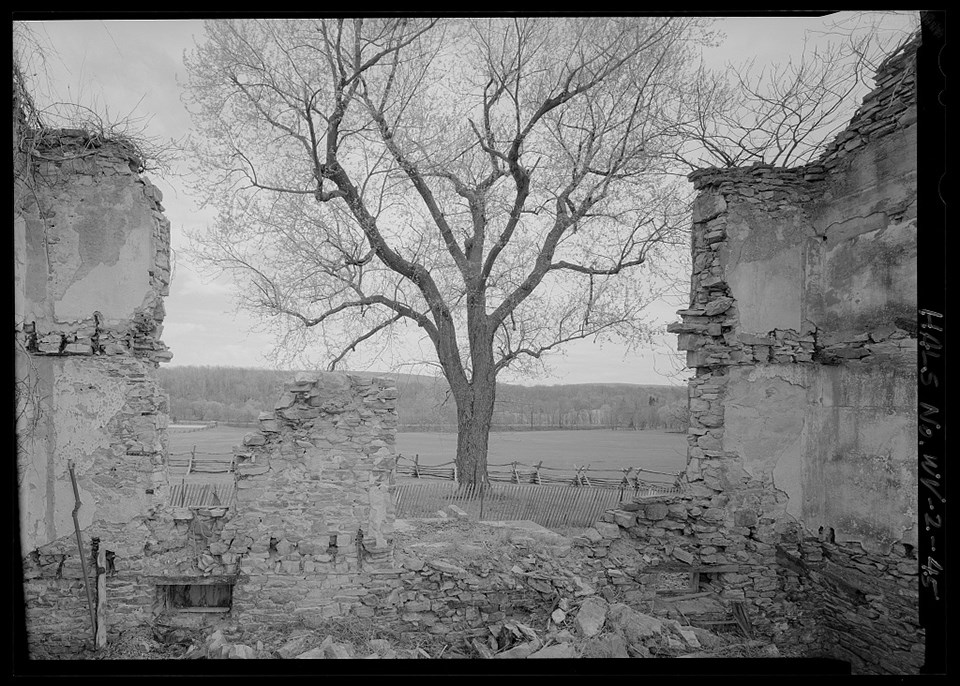
Jet Lowe, HALS Photographer. Extensive historical research indicates that these stone house ruins are the remains of a home built by John Hall Allstadt, son of Jacob Allstadt. The park seeks to confirm, however, if this house was built before the Civil War, or afterwards. The building was Greek Revival in style, which gained popularity before the Civil War. builders in the Shenandoah Valley were conservative in nature, and continued building styles after they became somewhat outdated. Therefore, a suitable construction date for the extant ruins, according to this evidence, could be circa 1872-1875. Whatever the exact construction date for the John H. Allstadt House, it is clear that Mr. Allstadt and his wife lived out the remainder of their days there. After passing through the family, the house then was used for housing the tenants of the Standard Farm until it was abandoned at an unknown date. In 1986, a fire destroyed the building’s interior and part of its exterior. As the National Park Service continues to document and preserve this ruin, we will conduct more research in hopes that further evidence will be found to verify the construction date. Check out the Historic American Landscape Survey for Allstadt Farm. Catalog Number: WV-2-45, 2009: View looking southeast of interior elevation of southeast facade. |
Last updated: August 8, 2022
