|
You are viewing ARCHIVED content published online before January 20, 2025.
Please note that this content is NOT UPDATED, and links may not work. For current information,
visit https://www.nps.gov/aboutus/news/index.htm.
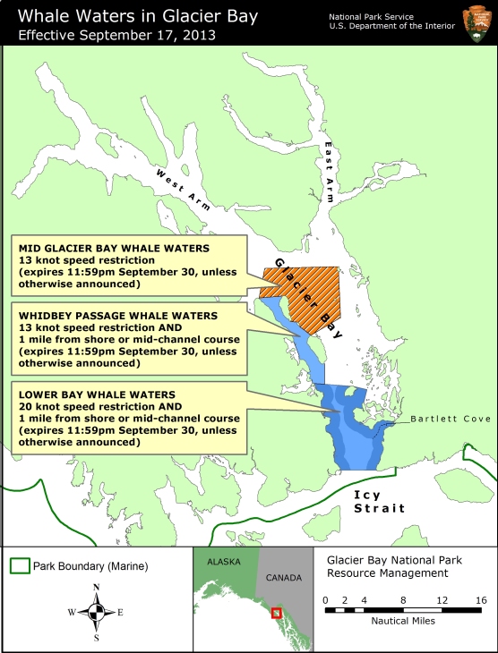
Contact: Gus Martinez, Acting Chief Ranger , 907-697-2230 Contact: Chris Gabriele, Whale Biologist, 907-697-2664 Glacier Bay National Park and Preserve Acting Superintendent Lisa Etherington announced today that a 13-knot vessel speed limit in mid-Glacier Bay will be implemented due to a shift in whale distribution into an area of regular vessel traffic. This change goes into effect beginning at 5AM Tuesday September 17th. Whale waters restrictions in Whidbey Passage and Lower Glacier Bay remain unchanged. The attached map shows the boundaries of all current whale waters in Glacier Bay. All Glacier Bay whale waters restrictions will expire at 11:59pm on September 30 unless otherwise announced. As shown on the attached map, the new mid-Bay whale waters are defined by the following boundaries:
The 13-knot speed limit for all vessels in Whidbey Passage whale waters remains unchanged. Vessels greater than 18 feet in length are restricted to a course one nautical mile from shore (or mid-channel in narrower passages) in Whidbey Passage. As described in detail in the August 8th press release, these restrictions apply throughout Whidbey Passage but exclude the inner waters of Berg Bay and Fingers Bay. Since the August 30th press release, in Lower Glacier Bay there is a 20 knot speed limit, and vessels greater than 18 feet in length are restricted to a course one nautical mile offshore (or mid-channel in narrower passages). Numerous whales are feeding throughout mid-Glacier Bay. Boaters should proceed cautiously in all areas where whales may be present because whales may surface in unexpected locations, posing a hazard to both the vessel and the whale. Vessels are prohibited from operating within ¼ nautical mile of a humpback whale in Park waters, including those Park waters outside Glacier Bay proper. Boaters are advised to verify whale waters designations prior to entering Glacier Bay by telephoning (907) 697-2627 or by contacting KWM20 Bartlett Cove on marine VHF radio. For a printer-friendly PDF version of this news release, please click here. |
Last updated: April 14, 2015