|
You are viewing ARCHIVED content published online before January 20, 2025.
Please note that this content is NOT UPDATED, and links may not work. For current information,
visit https://www.nps.gov/aboutus/news/index.htm.
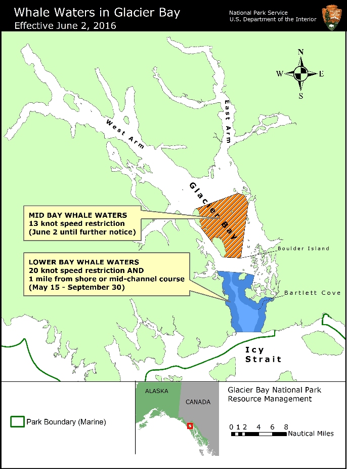
Contact: Albert Faria, Chief Ranger, 907-697-2230 Contact: Chris Gabriele, Whale Biologist, 907-697-2664 Glacier Bay National Park and Preserve Superintendent Philip Hooge announced today that a 13-knot vessel speed restriction will be implemented in the middle of Glacier Bay due to a high concentration of humpback whales. Numerous humpback whales, including a mother/calf pair, have been observed widely distributed in this area. Many of the whales are diving for 8-10 minutes at a time, making it difficult for vessels to spot them. At the same time, the 13 knot vessel speed limit in the West Arm of Glacier Bay that was implemented on May 28 will be removed, because many whales have moved out of the area. This change goes into effect beginning at 5AM Thursday, June 2.As shown on the attached map, current whale waters include the following areas:
Mid Glacier Bay - 13 knot speed restriction only: This area is defined by the following boundaries: Northern boundary: A line from the northern tip of Drake Island to the southern tip of the islets south of Sturgess Island Eastern boundary:A line from the southern tip of the islets south of Sturgess Island to the point of land at the northern entrance to South Sandy Cove, to the point of land at the southern entrance to South Sandy Cove, to the northern tip of Boulder Island Southern boundary: A line from the northern tip of Boulder Island to the southern tip of Willoughby Island Western boundary: A line from the southern tip of Willoughby Island to the southern tip of Drake Island
Lower Glacier Bay - 20 knot speed and course restriction: Annually from May 15 –September 30, a 20 knot speed and mid-channel course restriction are in effect in the the Lower Bay. This area includes all waters between the mouth of Glacier Bay and a line drawn between the northern tip of Strawberry Island and the northern tip of Lars Island. This boundary is shown on NOAA nautical charts of Glacier Bay. Note that there are also smaller concentrations of whales elsewhere in Glacier Bay, including in the lower West Arm where a vessel speed restriction implemented on May 28 has been removed. It is important for vessel operators to keep a sharp lookout and reduce speed when necessary. Vessels are prohibited from operating within ¼ nautical mile of a humpback whale in Park waters and are required to reduce speed if they find themselves within ¼ nautical mile of a whale. Speed and course restrictions in whale waters are intended to reduce whale disturbance and lower the risk of whale/vessel collisions, as authorized by Title 36 of the Code of Federal Regulations, Subpart N, 13.1174. Mariners are advised to verify whale waters designations prior to entering Glacier Bay by telephoning (907) 697-2627 or by contacting KWM20 Bartlett Cove on marine VHF radio. For a printer-friendly PDF version of this news release, please click here. |
Last updated: December 1, 2017