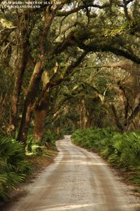
NPS Photo Cyclic Maintenance of the Main Road and other Primary Island Roads on Cumberland Island Cumberland Island National Seashore has received 2008 funding to perform cyclic maintenance on the Main Road and other key routes on the island. The Main Road, also known as Grand Avenue, is the primary artery on the island. Thirteen miles long, the road runs nearly the full length of the island from Dungeness in the south to Cumberland Wharf on the north end. As with all of the island’s roads it is generally a single-lane, unpaved track with a sand and shell base that varies in width from eight to twelve feet. The Main Road has been the principal transportation link on Cumberland Island for over 175 years and is listed on the National Register of Historic Places. Cyclic maintenance on the Main Road has not been conducted since 1998 and the park began requesting funds for the current project in 2005. Vehicle traffic, rainfall, wind, weathering, and general wear and tear over the single-lane, unpaved roads have caused the roadway to rut, settle, shift, and washboard. Such conditions have made the road difficult and uncomfortable to travel on for island visitors, residents, and park personnel. Washboard areas and ruts encountered at even low speeds (<25mph) have caused vehicles to lose traction and fishtail. Deep ruts have caused low-clearance vehicles to bottom out. In areas where conditions have become so poor the road is braided with multiple travel lanes as drivers avoid problem spots. Traveling the full length of the Main Road whether in a vehicle or on a bicycle can be a long, arduous, and painful trip. In addition, the current road conditions are extremely hard on vehicles and contribute to increased repairs and short vehicle life-spans. Actions proposed under this current cyclic project include filling and leveling ruts, dips, potholes, and other depressions that have developed in the roadbed. Additionally, areas where tree roots have become exposed will be covered to smooth out the bed and protect the roots. Fill material will consist of dredged sand removed from the spoil island located at Raccoon Keys on the island's south end. This spoil material is largely coarse grain sand and has been dumped from dredging operations in the nearby Intracoastal Waterway. In addition, crushed oyster shell will be purchased to level and restore to grade the approaches to five bridges. Other work includes grading of road segments that are overcome by washboard effects. Grading will also be employed where possible to restore the level of the roadbed by pulling material back into the road that has shifted to the edges and developed low berms along the roadside. While the vast majority of the project will focus on the Main Road, as funds and time permit the park may also address Coleman Avenue, Plum Orchard Spur, High Point Road, North Cut Road, and the loops through the Dungeness and Plum Orchard Historic Districts. The maintenance project is slated to begin later on in the spring and should be finished by the end of September. When completed the park anticipates having 19 miles of roadway in optimal condition. |
Last updated: April 14, 2015
