Photo courtesy of Collin Gilmore 
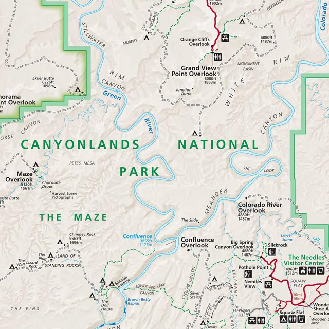
Hayduke TrailThe Hayduke Trail is a challenging, 800-mile backcountry route crossing Utah and Arizona. There is no established or maintained trail; hikers must use various forms of navigation to find their way along the route. Sections of the Hayduke pass through many national parks, including Arches, Bryce Canyon, Canyonlands, Capitol Reef, Grand Canyon, and Zion, and other public lands managed by the National Park Service, U.S. Forest Service, and Bureau of Land Management. PermitsAll Hayduke hikers planning to stay within either Arches or Canyonlands must obtain a backcountry permit. For backpacking permits in Arches, hikers should contact e-mail us or stop by the Backcountry Permit Office in Moab to inquire about availability. All backpacking/packrafting permits at Canyonlands can be reserved in advance on Recreation.gov. Backpackers can inquire about walk up availability (starting at $5) at either a district visitor center or the Backcountry Permit Office in Moab. There are both designated campsites and at-large backpacking zones that lie along or near the route. Camping without a permit or off permit is not allowed. Backpackers should plan accordingly and be able to cover mileage needed to reach the campsites or at-large backpacking zones on their permit. Camping in the river corridor is only permitted with a permit and required equipment. Swimming is not permitted across Spanish Bottom. Backpackers should arrange a shuttle in advance or bring their own vessel (and required equipment) to cross the Colorado River. 
NPS/Caleb Meyer Water AvailabilityThere are no reliable water sources in Arches or Canyonlands. Plan accordingly to pack the water you need or fill out a cache request to leave cached water along the route. During spring, there are some opportunities to find intermittent water in the Needles and the Maze. It is very unlikely to find any water in the autumn months. SeasonsSpring and fall are popular times of year to hike the Hayduke Trail. However, either season brings the possibility of freezing overnight temperatures, snow, and ice. Temperatures during summer months can exceed 100 degrees and hiking should be limited to early mornings. Many sections of the trail traverse across areas with little to no shade and minimal tree coverage. CachesHikers who want to drop either water, food, and/or gear caches should contact the Backcountry Permit Office at e-mail us for a cache request form. No caches are permitted without a signed, approved form. Caches without proper documentation will be removed from the backcountry. Adjacent Federal LandsFor information on the Hayduke Trail outside the national park, please contact the BLM Monticello Field Office. Additional Information
|
Last updated: April 29, 2025


