An official website of the United States government
Here's how you know
Official websites use .gov A
.gov website belongs to an official government
organization in the United States.
Secure .gov websites use HTTPS A
lock (
) or https:// means you've safely connected to
the .gov website. Share sensitive information only on official,
secure websites.
NC Highway 12 within Cape Hatteras National Seashore
National Park Service
Roads
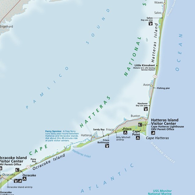
There are multiple ways to reach Cape Hatteras National Seashore. The northern entrance of Cape Hatteras National Seashore is located at the junction of US-64 and NC-12 in Nags Head, NC. The southern entrance is located on NC-12 just north of Ocracoke Village, NC (accessible by ferry only). Here are directions to reach the northern entrance of Cape Hatteras National Seashore from various locations.
North (From Richmond, VA)
Follow I-95 South to Richmond, VA. Take I-64 East toward Norfolk/Virginia Beach, VA. Take I-64 or I-664 to Chesapeake, VA. From I-64, take Exit 291B to Route 168, the Chesapeake Expressway*. Once in North Carolina, Route 168 turns into US-158 East. Follow US-158 East through Nags Head, NC to the junction of NC-12 South.
Follow US-64 East through Tarboro, Williamston, Plymouth, Columbia, and Manteo, crossing the Alligator River Bridge and the Virginia Dare Bridge. Keep going on US-64 East to Nags Head, NC, going over the Washington Baum Bridge, to the junction of NC-12 South. Turn right onto NC-12 South and you will be at the north entrance.
South (From Florence, SC)
Take I-95 North to Wilson, NC. Take US-264 East through Greenville, NC and Washington, NC. From Washington, NC, take US-17 to Williamston and follow US-64 East to Nags Head, NC and the junction of NC-12 South.
Addresses
Here are street addresses and GPS coordinates for some of the facilities within Cape Hatteras National Seashore.
Location
Street Address
Decimal Degrees
Degrees Minutes Seconds
Bodie Island Visitor Center and Lighthouse
8210 Bodie Island Lighthouse Road Nags Head, North Carolina 27959
35.818118,
-75.564222
35° 56' 12.9978",
75° 42' 32.256"
Hatteras Island Visitor Center and Lighthouse
46375 Lighthouse Road
Buxton, North Carolina 27920
35.251203,
-75.528176
35° 15' 4.3302",
75° 31' 41.4336"
Ocracoke Island Discovery Center
38 Irvin Garrish Highway
Ocracoke, North Carolina 27960
35.116291,
-75.986193
35° 6' 58.647",
75° 59' 10.2948”
Oregon Inlet Campground
12001 NC-12
Nags Head, NC 27959
35.800307,
-75.545214
35° 48' 1.1046”,
-75° 32' 42.7704"
Cape Point Campground
46700 Lighthouse Road
Buxton, NC 27920
35.236208,
-75.531138
35° 14' 10.3482”,
-75° 31' 52.0962"
Frisco Campground
53414 Billy Mitchell Road
Frisco, NC 27936
35.234596,
-75.608815
35° 14' 4.5456”,
-75° 36' 31.734"
Ocracoke Campground
4352 Irvin Garrish Highway
Ocracoke, NC 27960
35.125823,
-75.922504
35° 7' 32.9622”,
-75° 55' 21.0144"
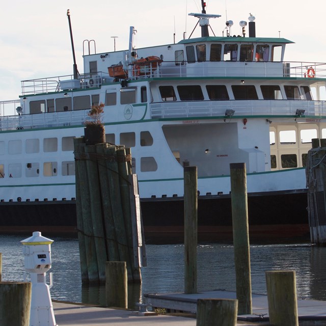
North Carolina Department of Transportation ferry traveling across Hatteras Inlet to Ocracoke Island
National Park Service
Ferries
Ferries provide a vital link to Ocracoke Island, with ferry service provided by North Carolina's Department of Transportation (NCDOT) to both ends of the island. Here are directions to reach the different ferry terminals. See the NCDOT Ferry website for additional information.
Hatteras Inlet Ferry
This ferry connects Hatteras Village, located on the southwestern end of Hatteras Island, with the northeastern end of Ocracoke Island. To reach the ferry terminal, follow NC-12 from Nags Head, NC all the way down Hatteras Island to the ferry terminal at the far end of Hatteras Village. The ferry crosses Hatteras Inlet in roughly 70 minutes and reservations are NOT required. Check the NCDOT Ferry website for current departure schedules.
Cedar Island Ferry
This ferry connects Sea Level, on the mainland, with Ocracoke Village, located on the southwestern part of Ocracoke Island. From I-40 East, take Exit 306 to US-70 East. Follow US-70 East to Sea Level, NC. In Sea Level, take NC-12 North to the ferry terminal. The Cedar Island Ferry crosses the Pamlico Sound in roughly 2-1/4 hours and reservations are required. Once in Ocracoke, follow NC-12 to the park entrance.
Swan Quarter Ferry
This ferry connects Swan Quarter, on the mainland, with Ocracoke Village, located on the southwestern part of Ocracoke Island. Take US-264 to NC-45 in Swan Quarter. Follow NC-45 South through the town to the Hyde County Courthouse. At the courthouse, turn on Oyster Creek Road (SR-1128) and follow to the terminal. The Swan Quarter Ferry crosses the Pamlico Sound in roughly 2-1/2 hours and reservations are required. Once in Ocracoke, follow NC-12 to the park entrance.
Planes at the Billy Mitchell Airport, part of Cape Hatteras National Seashore
National Park Service
Air
Norfolk International Airport (ORF) is located about 100 miles to the north of Cape Hatteras National Seashore in Norfolk, VA. To the west is Raleigh-Durham International Airport (RDU), which is located about 200 miles from the seashore. Commercial flights are available into both of these airports, with rental cars available for driving the rest of the distance to the seashore.
There are several ways to view or reach Cape Hatteras National Seashore by air. The Manteo/ Dare County Regional Airport (MQI) services private aircraft. The Billy Mitchell Airport (HSE) in Frisco, NC and Ocracoke Airport (W95) in Ocracoke, NC have 3,000' runways and tie-downs. Use is limited to daylight hours. There are NO services (fuel, hanger space, repair service, etc) at these two airports.