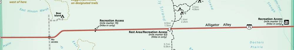
Interstate 75 -- from Mile Marker 50 west to Mile Marker 80 -- runs through the northern portion of the national preserve. Facilities at Mile Markers 51, 63 and 70 provide recreational backcountry access for those interested in exploring this vast natural area. Currently, travel into the backcountry from these access facilities is hike-in only, with a few exceptions. Dispersed camping is allowed from all areas except Mile Marker 70 north that enters the Bear Island Unit of the national preserve. The Bear Island Unit requires camping in designated sites only at the Bear Island, Pink Jeep or Gator Head Campgrounds. Access from Interstate 75 Click on the dropdowns below to learn more about the three Preserve access points off of I-75!
Arrival and DepartureThe site is accessible to westbound travelers on I-75. Those traveling east may make a u-turn at Exit 49 (Snake Road) to gain access to the facility. Upon leaving the facility and continuing west travelers may make a u-turn at Mile Marker 63 to travel east. ParkingThe facility provides parking and access into the Northeast Addition Lands of the Preserve. Visitors may choose to park and hike directly into the backcountry from the parking facility. You may also drive along the levee road -- on those portions open to street-legal vehicles -- and park along the road to hike into the backcountry or fish in the L-28i canal. If parking on the Levee Road, park in a manner that does not block other traffic. The speed limit is 25 mph, no trailers are allowed along the levee road except by special permit. Recreational Activities
Know Before You GoBe aware that there are several private properties in this area -- respect private property and do not trespass. Travel to the north into the Big Cypress Seminole Reservation, or to the south into the Miccosukee Reservation - by foot, bicycle, vehicle or watercraft - is by tribal permit only. Wildlife fencing is installed along I-75 to minimize the threat of wildlife, including the endangered Florida panther, from getting on to the busy roadway. If the automatic fence at the entrance of the parking area is not operational contact - 800-788-0511. ParkingThe facility provides parking and access into the Northeast Addition Lands of the Preserve. Visitors may park and hike directly into the backcountry from the parking facility. Recreational ActivitiesAt this time hunting and recreational off-road vehicle use are not allowed in this portion of the Preserve. Click the following links to learn where these recreational activities are currently allowed - Hunting, ORV Use. The Florida National Scenic Trail, along with a few associated trails, may be accessed from this area. Visitors may also hike off trail, but this requires individuals be familiar with orienteering by map and compass or by the use of a GPS - be prepared. Dispersed camping is allowed. Know Before You GoBe aware that there are private properties in this area -- respect private property and do not trespass. Wildlife fencing is installed along I-75 to minimize the threat of wildlife, including the endangered Florida panther, from getting on to the busy roadway. Be sure to close all gates behind you. Learn About This StopOn Friday morning, August 22, 2014, the Florida Department of Transportation (FDOT) opened the Mile Marker 63 rest area, along Alligator Alley. Crews completed the $8.8 million project on schedule. Work began in spring 2013 to replace the former rest area with a larger restroom facility, an upgrade of the wastewater and water treatment plant, improvements to two recreational access areas adjacent to the Big Cypress National Preserve nature trails, and construction of a new public safety center. The design/build project increases the number of restroom facilities from 30 to 44 including the addition of four family restrooms. Each recreational area will accommodate up to 15 vehicles and 25 trucks or trailers. Improvements also include various site improvements such as lighting, landscaping, and resurfacing. The new public safety center will accommodate four to six Collier County EMS personnel and will assist in reducing response times to incidents along Alligator Alley. With FDOT’s funding in place for Collier County’s operation of the public safety center, county staff has begun preparations to occupy the new facility. It is expected to be operational in late 2014. Heading WestboundThere are no restrooms or potable water available. This facility is accessible from I-75 eastbound only. This facility has a walk-through gate in the wildlife fence* that allows access into the Bear Island Unit of the Preserve. Please close the gate behind you. Hiking, walk-in hunting, fishing and camping in designated areas (Bear Island, Pink Jeep, and Gator Head Campgrounds) is allowed from this site. There are no marked hiking trails originating from this site. Travel requires individuals be familiar with orienteering by map and compass, or by the use of a GPS unit. Upon leaving the facility, continuing to the west, a u-turn can be made at Mile Marker 80 to return eastbound. Heading EastboundThere are no restrooms or potable water available. This facility is accessible from I-75 eastbound. This facility has a walk-through gate in the wildlife fence* that allow access into the Turner River Unit of the Preserve. Upon walking into the area you will be on designated off-road vehicle trail TRU-2 (Cypress Lane). You can follow the trail to a network of other designated trails that allow for off-road vehicle use (must use other access points), hiking and biking. Hiking, biking, walk-in hunting, fishing and dispersed camping is allowed from this site. Biking is allowed only on designated off-road vehicle trails, and not all designated trails will be suitable for biking. You may hike on designated trails or choose to orienteer with map and compass or GPS cross-country, be prepared. Upon leaving the facility, continuing east, a u-turn can be made at Mile Marker 63 to return westbound. Know Before You GoBoth the Bear Island and Turner River Units of the national preserve are included within the Big Cypress Wildlife Management Area, which is managed in partnership with the Florida Fish & Wildlife Conservation Commission. Hunting and fishing requires appropriate state licenses. Be sure to familiarize yourself with state fishing regulations and wildlife management area-related hunting regulations. Hunters are reminded to check in and out with the Florida Fish and Wildlife Conservation Commission check stations. |
Official websites use .gov
A
.gov website belongs to an official government
organization in the United States.
Secure .gov websites use HTTPS
A
lock (
) or https:// means you've safely connected to
the .gov website. Share sensitive information only on official,
secure websites.