Last updated: January 21, 2026
Article
Nighttime Navigation and Light Station Landscapes
Navigating Under the Night Sky
Celestial navigation has been practiced throughout history, on both land and sea. It uniquely combines art and science for the purpose of wayfinding. From the Phoenicians to the Polynesians to the Corps of Discovery, many cultures have utilized the night sky when navigating the world’s waterways. These mariners and travelers would identify a star on the horizon in the direction they wanted to navigate and point the bow of their ship in that direction (Osmond 2007, 165). While the stars were useful for navigation, they didn’t help early sailors steer clear of hazards like shallow water or rock outcroppings.
Wikimedia (with CC BY-SA 3.0 license)
We don’t know if this legend is true, but we do know that the Greeks did build one of the seven wonders of the ancient world, the lighthouse in Alexandria, also known as the Pharos. Construction on the Pharos was initiated in 280 B.C., and at its competition it stood as the largest lighthouse ever built. Earthquakes in the 14th century toppled the once soaring structure into the bay of Alexandria (DeWire 2010, 4-6).

NPS Photo (in Boston Harbor Islands Cultural Landscape Report, Olmsted Center for Landscape Preservation)
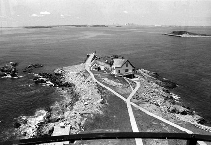
The first lighthouse in America was built in Boston Harbor. In 1713, a group of Boston Merchants petitioned the Massachusetts state legislature to build a lighthouse to help vessels navigate into Boston Harbor. Construction was completed in 1716 on Little Brewster Island in the main shipping canal in Boston harbor (Dolin 2016, 2).
Light Stations of the Great Lakes
The visibility of landforms meant that geo-navigation was the primary means of wayfinding in the Great Lakes region, a practice well known to Native Americans who navigated the waters by canoe and developed place names for geographic features.There were few navigational aids available to Indigenous mariners. They relied on dead reckoning for planning their course and intimate knowledge of the shore line to make their way. Place names given to coastal features, to which stories would often be attached, helped to keep alive knowledge of coastal features. For example, the Anishinaabeg legend behind the naming of Sleeping Bear Dunes accounts for the prominent headland and the two islands, North and South Manitou that help form the Manitou Passage. In the story a raging forest fire on the Wisconsin shore drove a mother bear and her two cubs into the lake. As they swam to the safety of the Michigan shore, the two cubs became tired and drowned. The Great Spirit Manitou then created the great dune in memory of the grieving mother bear and made North and South Manitou Islands to mark were the two cubs perished (Karamanski 2017, 14).
While the Great Lakes remain wild, the development of charts, lighthouses, buoys, improved channels, locks, harbors, and cities were all attempts to domesticate these great inland seas. Those features are as much a part of the process of “settlement” as such well-recognized markers of terrestrial development as roads, farms, factories, and towns (Karamanski 2017, 7).

NPS Photo
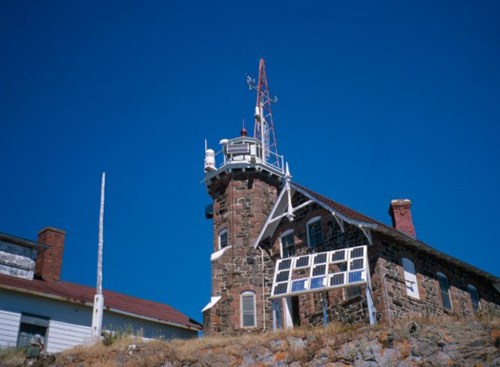
Today some light stations have thriving towns with shipyards and engineered ports that have developed around them. Other light stations are now within the boundaries of national parks and are carefully managed and interpreted because of their historic significance. Lightstations in the Midwest Region of the National Park Service can be found at Apostle Islands National Lakeshore, Isle Royale National Park, Pictured Rocks National Lakeshore, and Sleeping Bear Dunes National Lakeshore.
Seeing Beyond the Lighthouse: Light Station Cultural Landscapes
The importance of light station cultural landscapes to American history cannot be understated. While some stations are individually recognized by the National Historic Landmark and National Register Programs, the National Park Service manages a unique collection of light stations. For example, the light stations at Apostle Islands National Lakeshore are, according to Karamanski, “an outstanding collection of aids to navigation that represent the evolution in design technology” (2017, 256).
NPS Photo
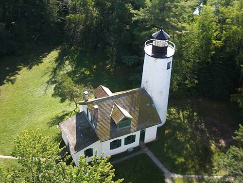
Examples of defining features of a light station landscape include walkways, gardens, and remnant fruit trees once tended to by the station keeper, their family, and occasionally an assistant keeper. They are tangible reminders that people domesticated and shaped these often isolated locations.
Cultural Landscape Reports for these sites guide park management on how to preserve, restore, and maintain the features of the landscape and enhance integrity so the site evokes the setting, feeling, and association realitive to the period of significance. Management of the light station resources in this way provides an opportunity for the visiting public to fully understand and appreciate the histioric value of these resources and the daily activites associated with being a keeper of the light.

NPS Photo
Explore These Cultural Landscapes
- Cultural Landscape Report, Historic Structures Report, and Environmental Assessment for Five Light Stations of Apostle Islands National Lakeshore (Michigan Island, Outer Island, Devils Island, Long Island, Sand Island)
- Coming Through With Rye: An Historic Agricultural Landscape Study of South Manitou Island (Sleeping Bear Dunes National Lakeshore)
- Edisen Fishery & Rock Harbor Lighthouse Cultural Landscape Inventory report (Isle Royale National Park)
Sources and More
Karamanski, Theodore J. Great Lakes Navigation and Navigational Aids: Historical Context Study. Washington, D.C.: National Park Service, 2017.Best, Elsdson. "Polynesian Navigators: Their Exploration and Settlement of the Pacific." Geographical Review, No. 5 (March 1918): 169-82.
Osmond, Meredith, Malcolm Ross, and Andrew Pawley. The Lexicon of Proto Oceanic: The Culture and Environment of Ancestral Oceanic Society: 2 The Physical Environment. ANU E Press, 2007.
DeWire, Elinor, and Dolores Reyes-Pergioudakis. The Lighthouses of Greece. Sarasota, FL: Pineapple Press, 2010.
Editors of the Encyclopaedia Britannica. "Pharos of Alexandria." In Encyclopædia Britannica online, June 29, 2016 https://www.britannica.com/topic/Pharos-of-Alexandria. Accessed 4 April 2018.
Dolin, Eric. Brilliant Beacons: A History of the American Lighthouse. New York: Liveright Publishing, 2016.


