Last updated: December 1, 2025
Article
SECN Highlights August 2023


NPS photo
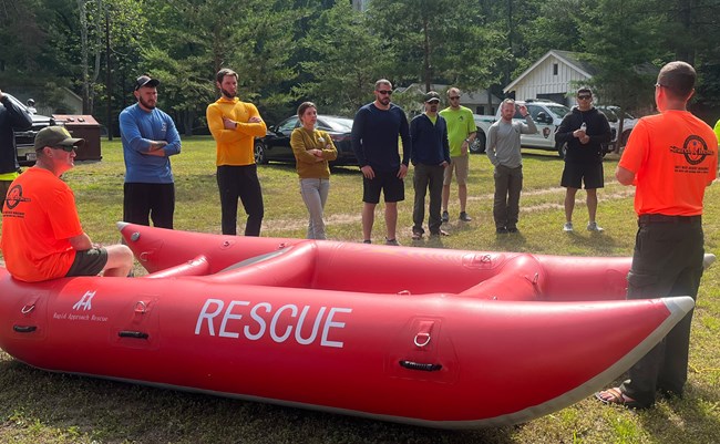
Swiftwater Rescue Training for Katie and Eric
Aquatic Ecologist Eric Starkey and Hydrologic Technician Katie Dagastino spent a week in July in New River Gorge National Park and Preserve participating in the second Swift Water Incident Management (S.W.I.M.) course. The course provides potential swift water rescue technicians with the fundamentals of survival in moving water and is recommended for anyone who may be called upon to enact in-water rescues. Some of the top NPS swift water rescue instructors came together to pass on their knowledge to students from around the country. Katie and Eric gained knowledge in hydrology, hazards, risk management, incident size-up, and scene management as well as practical skills such as self-rescue, swift water swimming, and the fundamentals of shore, boat, and in-water rescues. Additionally, they were introduced to the basics of paddle boat handling, basic rope rescue techniques, and mechanical advantage systems.

NPS photos

NPS photo / Wayne Ryan
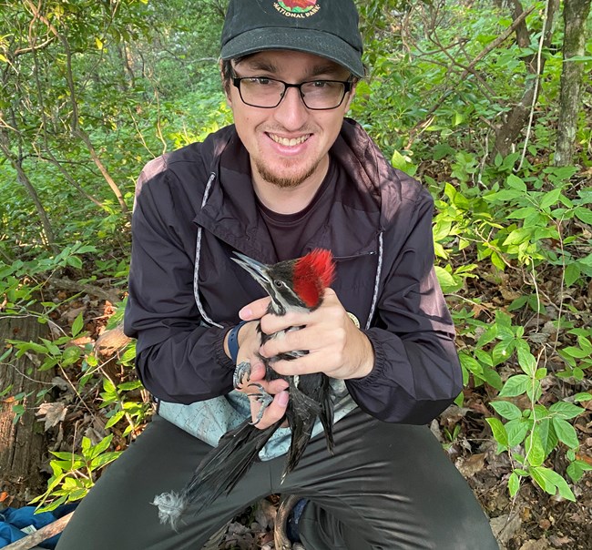
Wayne Tracks Birds in North Carolina
Wayne Ryan, SECN Wildlife CESU Intern, recently conducted field research involving bird banding, mist-netting, and point count surveys at the USDA Forest Service Coweeta Hydrologic Laboratory in the Southern Appalachian Mountains of North Carolina. With the use of mist-nets he was able to capture and take different measurements on birds. For the network, Wayne has been assisting with vocalization classifications, field season preparations, ARD deployments and retrievals and data entry.

NPS photos
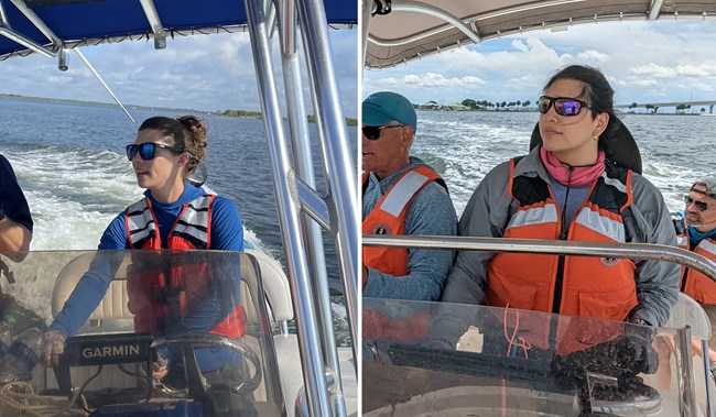
Abby and Katie Get Boating Skills
Abby Gonzalez, SECN Coastal Technician, and SECN Hydrologic Technician Katie Dagastino, recently completed Motorboat Operator Certification Course (MOCC) Training at Merritt Island National Wildlife Refuge Headquarters in Titusville, Florida. The training was conducted by U.S. Fish and Wildlife Service and consisted of motorboat safety requirements in preparations, navigation, operations, emergency procedures, rescue, fire suppression, and seamanship. Abby and Katie learned how to make safe and informed decisions about their own safety and safety of the crew, familiarized themselves with watercraft safety equipment and gear, and demonstrated proper motorboat operations in the work environment.

Recent Publications
The Southeast Coast Network recently published the following reports:
- Protocol for Monitoring Estuarine Water and Sediment Quality in Selected Southeast Coast Network Parks: Protocol Narrative. Available at: DataStore - Protocol for monitoring estuarine water and sediment quality in selected Southeast Coast Network parks: Protocol narrative—version 2.0 (nps.gov)
- Terrestrial Vegetation Monitoring at Ocmulgee Mounds National Historical Park: 2021 Data Summary. Available at: DataStore - Terrestrial vegetation monitoring at Ocmulgee Mounds National Historical Park: 2021 data summary (nps.gov)
- SOP 1.1.02 Uploading Points to GPS Units—Version 2.0. Available at: DataStore - Standard Operating Procedure 1.1.02 Uploading Points to GPS Units—Version 2.0 (nps.gov)
- SOP 1.4.01 Programming and Maintenance of Automated Recording Devices for Vocal Anuran and Landbird Monitoring—Version 2.0. Available at: DataStore - Standard Operating Procedure 1.4.01 Programming and Maintenance of Automated Recording Devices for Vocal Anuran and Landbird Monitoring—Version 2.0 (nps.gov)
- SOP 1.4.24 Inventory, Maintenance, and Testing of Rechargeable ARD Batteries—Version 1.2. Available at: DataStore - Standard Operating Procedure 1.4.24 Inventory, Maintenance, and Testing of Rechargeable ARD Batteries—Version 1.2 (nps.gov)
- SOP 1.4.22 Deployment and Retrieval of Automated Recording Devices for Vocal Anuran and Landbird Monitoring—Version 3.0. Available at: DataStore - Standard Operating Procedure 1.4.22 Deployment and Retrieval of Automated Recording Devices for Vocal Anuran and Landbird Monitoring—Version 3.0 (nps.gov)
- SOP 1.4.31 Navigation to Southeast Coast Network Sampling Locations for Landbird and Vocal Anuran Monitoring—Version 3.0. Available at: DataStore - Standard Operating Procedure 1.4.31 Navigation to Southeast Coast Network Sampling Locations for Landbird and Vocal Anuran Monitoring—Version 3.0 (nps.gov)
- SOP 1.4.32 Classification of Landbird Vocalization Recordings—Version 1.0. Available at: DataStore - Standard Operating Procedure 1.4.32 Classification of Landbird Vocalization Recordings—Version 1.0 (nps.gov)
- SOP 1.4.33 Classification of Anuran Vocalization Recordings—Version 1.0. Available at: DataStore - Standard Operating Procedure 1.4.33 Classification of Anuran Vocalization Recordings—Version 1.0 (nps.gov)
- Landbird Community Monitoring: 2021 Data Summary Reports and Species Distribution Maps for Cape Lookout National Seashore, Cumberland Island National Seashore, Fort Sumter and Fort Moultrie National Historical Park, Horseshoe Bend National Military Park and Kennesaw Mountain National Battlefield Park. Reports available at: DataStore - Landbird Monitoring in Southeast Coast Network parks: 2021 Data Summaries Maps available at: DataStore - Landbird Monitoring in Southeast Coast Network Parks: Printed Species Maps 2021
- Vocal Anuran Community Monitoring: 2017 Data Summary Reports and Species Distribution Maps for Canaveral National Seashore, Congaree National Park, Fort Frederica National Monument, Moores Creek National Battlefield, and Ocmulgee Mounds National Historical Park. Reports available at: DataStore - Vocal Anuran Monitoring in Southeast Coast Network parks: 2017 Data Summaries (nps.gov) Maps available at: DataStore - Vocal Anuran Monitoring in Southeast Coast Network Parks: Printed Species Maps 2017 (nps.gov)
- Vocal Anuran Community Monitoring: 2021 Data Summary Reports and Species Distribution Maps for Cape Lookout National Seashore, Cumberland Island National Seashore, Fort Sumter and Fort Moultrie National Historical Park, Horseshoe Bend National Military Park and Kennesaw Mountain National Battlefield Park. Reports available at: DataStore - Vocal Anuran Monitoring in Southeast Coast Network parks: 2021 Data Summaries (nps.gov) Maps available at: DataStore - Vocal Anuran Monitoring in Southeast Coast Network Parks: Printed Species Maps 2021
- Landbird 2023 Cumulative Data Package. Available at: DataStore - SECN Landbird 2023 Cumulative Data Package (nps.gov)
- Anuran 2023 Cumulative Data Package. Available at: DataStore - SECN Anuran 2023 Cumulative Data Package (nps.gov)
Tags
- cape hatteras national seashore
- cape lookout national seashore
- congaree national park
- fort pulaski national monument
- fort sumter and fort moultrie national historical park
- timucuan ecological and historic preserve
- canaveral national seashore
- fort matanzas national monument
- cumberland island national seashore
- ocmulgee mounds national historical park
- horseshoe bend national military park
- chattahoochee river national recreation area
- kennesaw mountain national battlefield park
- coastal wetlands monitoring
- shoreline change monitoring
- wadeable stream habitat monitoring
- estuarine water and sediment quality
- water quality monitoring
- landbird community monitoring
- vocal anuran community monitoring
- terrestrial vegetation monitoring
- secn network highlights
