Sea Caves

View of kayakers from the back, entering caves in a sandstone formation.
Mainland Sea Caves

NPS Photo/M. Sweger

Sea Caves

Centuries of wave action, freezing, and thawing have sculpted shorelines throughout Apostle Islands National Lakeshore. Some of the Great Lakes' most spectacular scenery occurs where these forces interact with sandstone of the Devils Island Formation to create extensive sea caves. Nature has carved delicate arches, vaulted chambers, and honeycombed passageways into cliffs on the north shore of Devils Island, Swallow Point on Sand Island, and along the mainland near the Lakeshore's western boundary. People come to Apostle Islands National Lakeshore in summer and winter to visit the sea caves and witness Lake Superior's ever-changing handiwork.

The caves' beauty varies dramatically with the season. In summer the red sandstone is sandwiched between sapphire blue lake and emerald green forests that grow right up to the brink of the cliffs. Large waves generate plumes of spray and thunderous explosions as they surge into the sea caves. While visitors must enjoy these scenes from a distance, such is not the case when the lake is tranquil. Under calm conditions, kayakers can explore the caves' deepest recesses while listening to the murmur of water against rock.

Ancient Sands, Devils, Apostles, and Sea Caves

The story of the Apostle Islands Sea Caves is an ancient one. After the volcanism and subsidence of the failed Keweenaw Rift, high-energy, braided streams carried sand and gravel from granitic highlands in what is now southern Minnesota to the basin where the Apostle Islands eventually formed. Sediments filled the basin for hundreds of millions of years, long before fossils, and are described as three formations making the Bayfield Group. The Devils Formation, named after the island, is about 300' thick and accumulated in wide-spread sand flats covered with shallow ponds, some only a few inches deep, connected by shallow channels. Sand deposited in this environment was thinly-bedded, fine-grained, contains ripple marks, and is situated between the Orienta and overlaying Chequamegon Formations.
The thin layers that make up the Devils are more porous and vulnerable to erosion. Where wave action attacks and undercuts the base of a cliff at the water level, a feature known as a "re-entrant" develops. Sea caves are produced when several re-entrants form and join behind the face of a cliff, leaving behind supporting pillars and arches. These sandstones dip slightly to the southeast causing them to appear at the surface. The Devils Island Formation outcrops along a line from Devils Island, though the eastern edge of Sand Island at Swallow Point, and along the mainland section of Sea Caves east of Mawikwe Bay, thus presenting the Apostle Islands National Lakeshore's spectacular sea caves to the world.

 
Visitors inside and climbing into an ice cave.
Inside one of the Mainland Ice Caves

NPS photo/N. Howk

Ice Caves

The frozen surface of Lake Superior from Saxine Creek to Lunch Beach is closed to the public unless the Superintendent has declared the ice caves open, due to high risk for personal injury, slow emergency response time to that area, and circulation of misinformation.

By February, an ice bridge might connect Sand Island to the mainland. The lake surface is usually a frozen white expanse. Lakeshore cliffs form a crimson red border to this arctic landscape. Pillars of ice extend to the cliff tops where waterfalls have hardened in place. Frozen lakewater encrusts the base of the cliffs. Inside the caves awaits a fairyland of needlelike icicles. The formations change from chamber to chamber and from day to day. In the right conditions, visitors can explore these ice caves.

Apostle Islands National Lakeshore staff checks the ice and monitors the weather to determine when the Mainland Caves are accessible. NPS is not, however, able to check every day. Cold temperatures can form thick ice, but wind and waves can break up that ice in a matter of hours, and make it unstable. Low Risk ice conditions allow the area to be deemed accessible to visitors.

 
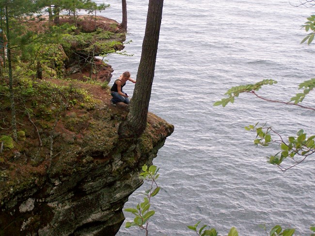
A kneeling woman at the edge of a cliff over the water, leaning against a tree trunk.
Hikers and pets have fallen from the fragile cliffs. Stay back from the edge.

NPS photo

Getting there

Summer

The sea caves are best seen by boat. Apostle Islands Cruise Service provides a variety of boat tours throughout the summer, which can include the Devils Island or mainland sea caves. Kayak outfitters in Bayfield guide day trips to the mainland caves and Sand Island throughout the summer. Kayakers with their own boats wishing to visit the mainland caves will find a good launch point at the end of Meyers Road. This is located about 18 miles west of Bayfield off Highway 13. Boaters wishing to visit the Sand Island caves will find a boat launch at Little Sand Bay, 13 miles north of Bayfield.

Winter

Access to the mainland ice caves is from Meyers Beach. Every winter, the frozen surface of Lake Superior from Saxine Creek to Lunch Beach is closed to the public unless the Superintendent has declared the ice caves open. Please check the current conditions or the park's Facebook page for status of the ice caves before visiting.

A Safe Visit

Visitors to the caves face a number of potential hazards. Boaters should avoid sea caves when conditions are rough. Get the marine weather forecast before leaving on your trip. Personal flotation devices (PFDs) should be worn. Kayakers should not visit the caves alone. When walking along cliff tops remember that this is an eroding shoreline, and stay back from the edge.

Winter visitors need to be especially careful:

  • Do not take chances if ice conditions are unstable. Beware of cracks in the ice even on the coldest days. Carry an ice bar to test ice thickness.
  • Sub-zero temperatures and bitter wind chills are common. Warm clothing is a must.
  • Walking on ice can be extremely slippery- wear sturdy boots to prevent slipping.
  • Watch out for falling ice and rock in and around the cliffs and caves.

If planning a winter trip to the caves, call the automated Apostle Islands Ice Line at (715)779-3398, extension 3, for current ice conditions at the mainland caves, or check the current conditions or the park's Facebook page for status of the ice caves before visiting.


The Changing Face of Cliffs

A tree-topped sandstone cliff with a frozen lake and blue sky. A tree-topped sandstone cliff with a frozen lake and blue sky.

Left image
2005
Credit: NPS photo

Right image
2008
Credit: NPS photo

These easily eroded sandstone cliffs are constantly changing. In early 2008, the pedestal forming the arch collapsed, exposing a fresh rock face.

Last updated: June 16, 2022

Park footer

Contact Info

Mailing Address:

PO Box 770
Bayfield, WI 54814

Phone:

715 779-3397

Contact Us

Tools