How long does it take to get to the Lighthouse?From the Bear Valley Visitor Center, driving time to the Lighthouse parking lot is about 45 minutes. It will take you another 15 minutes to walk from the parking lot to the Lighthouse Visitor Center. The lighthouse itself is 313 stair steps down the cliff-face. Check our Visitor Centers page for more information on when the visitor center, the stairs, and the lighthouse may be open. Directions from the Bear Valley Visitor Center to the Point Reyes Lighthouse. Learn more on our Visit the Point Reyes Lighthouse page. I only have so much time, what should I see/do?For making the most of your visit, take a look at our Trip Ideas page. What time does the park close?The park does not have an official closing time. However, park visitor centers have various hours of operation, and all beach fires must be out by 10 pm. All areas in the park are closed to visitor vehicle parking between the hours of midnight and 6 am with the exception that visitors holding backcountry camping permits may park at established trailheads and authorized visitors staying overnight at the Clem Miller Environmental Education Center, Limantour Lodge, and the Lifeboat Station may park at those locations or trailhead parking lots. Any other overnight parking and use must be approved by the Chief Ranger's office. Sleeping in parked vehicles is strictly prohibited within park boundaries. Where are dogs allowed in the park?Within Point Reyes National Seashore, dogs are allowed only on South Limantour Beach, North and South Point Reyes Beaches, and Kehoe Beach. They are not allowed on any hiking trails. Pets must be on a leash at all times; the leash must be no longer than 6 feet. Visit our Pet Regulations page for more information and information on seasonal closures. I'd like to go for a hike. What would you recommend?See our Trail Guide & Suggested Hikes page. 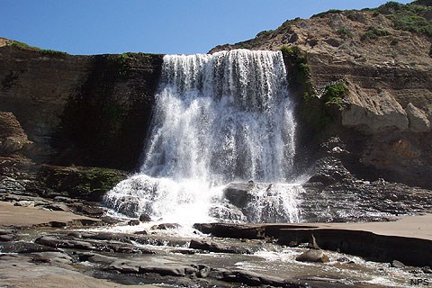
How do I get to Alamere Falls?Alamere Falls is deep within the Phillip Burton Wilderness and requires a 13-mile (20-km) minimum round-trip hike. Allow 6.5 hours for the hike and start your hike approximately 3.5 hours before low tide. See our Alamere Falls page for more information. 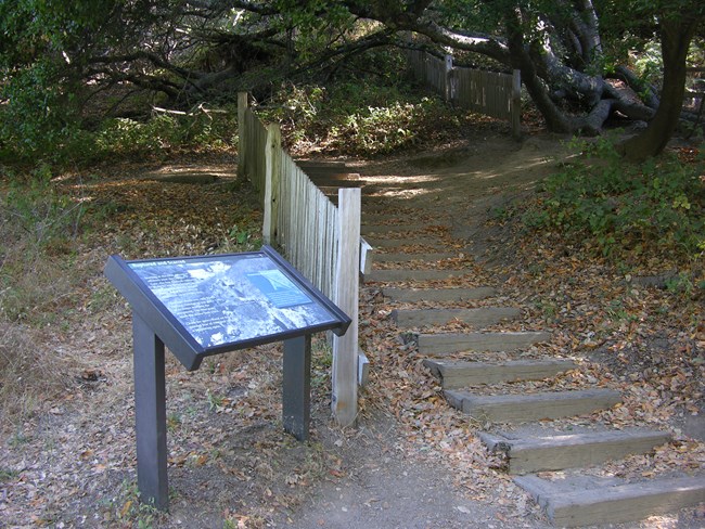
NPS Photo Where can I find the trail that shows the fence displacement from the 1906 earthquake?The Earthquake Trail is located across the parking lot from the Bear Valley Visitor Center. The trailhead can be found adjacent to the picnic area restrooms. 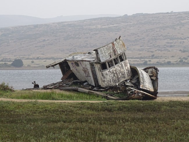
NPS Photo Where is the shipwreck?The "shipwreck" is the Point Reyes, an old fishing boat that was purchased by a resident of Inverness who intended to repair the vessel. The new owner intentionally beached the boat on the Tomales Bay side of what is now the Dixon Marine Services, Inc. building in "downtown" Inverness. While the boat is on NPS land, one must cross private property to best view it. As of May 2016, the Inverness Store allows the public to view the boat from the east end of its parking lot. Please do not otherwise trespass on the private property in the area. In February 2016, the fishing boat was severely damaged by a mysterious fire. By 2023, the sides of the fishing boat had largely collapsed. Please do not climb on the fishing boat. Note: The Point Reyes fishing boat should not to be confused with the historic Point Reyes dairy schooner that operated out of Schooner Bay in Drakes Estero's during in the 1800's. 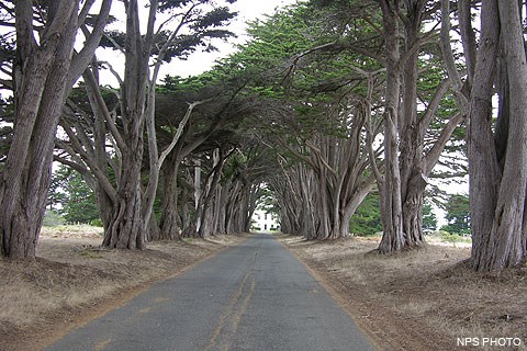
Where is the tree tunnel?The "tree tunnel" is formed by Monterey cypress that line the driveway that leads to the Historic RCA Coast Station KPH. Follow Sir Francis Drake Boulevard east toward the Point Reyes Lighthouse until you see the signs for the North District Operations Center. Please visit our Historic KPH Maritime Radio Receiving Station and Cypress Tree Tunnel page for more information. 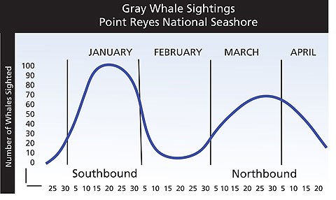
When is the best time to see whales?Whales are most often sighted from January through April when the gray whale migration is under way. The gray whales migrate south from Alaska to Baja California, with peak viewing in mid-January. Mid-March is peak viewing for the northern migration, with mothers and calves often passing very close to shore in April. Visit our Whale Watching page for more information. 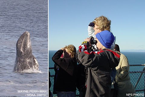
Where can I see whales?The best spot to view gray whales in the park is at the Lighthouse and Chimney Rock areas. Tomales Point, Drakes Beach, the Point Reyes Beach, and Limantour Beach also provide good vantage points for viewing whales. Visit our Whale Watching page for more information. Where can I see the elephant seals?While elephant seals may be viewed from the Elephant Seal Overlook near Chimney Rock year-round, they are most numerous from December through March during the pupping and mating season. Visit our Viewing Elephant Seals page for more information. 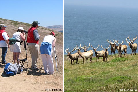
Where can I see the tule elk?The majority of the National Seashore's tule elk reside at the north end of the park on Tomales Point. A herd of betwen 200 and 400 elk may be seen there, often from the roadside and parking lot area near Pierce Ranch. In 1998, a few dozen tule elk from the Tomales Point preserve were released in the wilderness area north of Limantour Beach and elk from this free-ranging herd may be viewed from Limantour Road and the Estero, Glenbrook, Muddy Hollow, and Muddy Hollow Road trails. A few of these free-ranging elk moved to the west side of Drakes Estero and their descendents can frequently be seen from Drakes Beach Road. Visit our Viewing Tule Elk page for more information. Where are good areas for birding?Abbotts Lagoon, Chimney Rock, Drakes Estero, Estero de Limantour, Five Brooks Pond, the Giacomini Wetlands, and the Lighthouse area are all good places to view birds. Visit our Birding at Point Reyes page for more information. Please note: employee housing as well as park administrative, maintenance, operations, and storage facilities, including, but not limited, to access roads, outbuildings, grounds, and docks, are closed to public use. Where is a good place to eat/sleep nearby?Check our Restaurants and Lodging pages for information regarding restaurants and lodging. Our Goods & Services pages can help you find other services in and around Point Reyes National Seashore. Is there camping in the park?Yes, however it is all backcountry (hike-in or boat-in) camping; there is no car camping within the National Seashore. The nearest car camping is located at Olema Campground (1-800-655-2267) and Samuel P. Taylor State Park (1-800-444-7275). For more information about camping in the National Seashore, visit our Campgrounds, Backcountry Camping, and A Guide to Low Impact Boat Camping pages. For more information about camping in the surrounding area, visit our Nearby Campgrounds page. Can I have a fire in the park?Fires are allowed on beaches by permit only. For more information, visit our Beach Fires page or call the Bear Valley Visitor Center at 415-464-5100 x2 x5. Can I fish at Point Reyes?Fishing is permitted under California State Hunting and Sport Fishing Regulations. By state law, no fishing is allowed in:
For more information, visit our Fishing at Point Reyes page. I want to hold an event at Point Reyes National Seashore? Do I need a permit?Special use permits are required for Special Events including, but not limited, to weddings, sporting events, picnics in the reservable Bear Valley Group Picnic Area, and picnics with more than 100 persons. For more information or to obtain a permit, contact the park's Special Use Coordinator by email. A loved one has recently passed away and Point Reyes was one of their favorite places. Can we scatter their ashes or have a memorial bench installed in the park?Please visit our Permits & Reservations page to learn how to obtain a permit for scattering ashes. Memorialization—such as monuments, crosses, markers, benches, etc.—is not authorized. Can I smoke marijuana during my visit to Point Reyes National Seashore?No, the use and/or possession of marijuana remains illegal on federal lands, including Point Reyes National Seashore and other National Park Service areas. 
Can I fly my drone at Point Reyes?Launching, landing, or operating a remotely operated aircraft (aka "remotely piloted aircraft," "unmanned aircraft," or "drone") from or on lands and waters administered by the National Park Service within the boundaries of Point Reyes National Seashore is prohibited except as approved in writing by the superintendent. If you observe drone use in Point Reyes National Seashore, please call park dispatch at 415-464-5170 or contact staff at the nearest Visitor Center as soon as possible. If you observe drone use in other National Park Service areas or if you find photographs or videos online or elsewhere that were illegally taken within National Park Service areas from drones, you can report the violation to the National Park Service tip line at 888-653-0009 or by email. Can I use a metal detector at Point Reyes?Title 36 of the Code of Federal Regulations Section 2.1 (a) (7) prohibits the use or possession of metal detectors, magnetometers, and similar equipment within the jurisdiction of national park lands. However, such devices may be transported through park areas provided they are broken down, dismantled, and cased in such a way that prevents their ready use. The hobby of metal detecting is generally considered to be "treasure hunting". Even if the user is searching for items of relatively low value, such as recently issued coins or the like, there is great potential loss of items with significant historical or cultural value. The National Park Service is mandated to protect historic features and artifacts for the enjoyment of future generations. Therefore, the use of metal detectors within park areas is considered to be incompatible with the mission of the Service. Will there be any ranger-led programs offered during my visit?Visit our Ranger-Guided Programs page and check out our Calendar of Events to learn what programs you will be able to attend. What time does the movie start at the Bear Valley Visitor Center?Audio-visual programs are shown upon request anytime the Bear Valley Visitor Center is open, provided the video will conclude by closing time. "I hit an animal while driving. What should I do?" or "I found a roadkilled animal. What should I do?"Please contact park dispatch at 415-464-5170 if you hit an animal while driving within the National Seashore and there is significant damage to your vehicle, or if you see a recently roadkilled animal that is creating a road hazard on a park roadway. You can also help increase researchers' understanding of the extent of roadkill and help develop innovative ideas for reducing roadkill by reporting the roadkill to the California Roadkill Observation System. Listen to KQED's September 14, 2023, Forum episode "How We Can Change Our Roads to Help Our Wildlife" to hear a conversation between host Mina Kim and conservation journalist Ben Goldfarb. They discuss Goldfarb's new book Crossings, which examines the impact of our planet's 40 million miles of roads on the natural world and how, through the study of road ecology, we can find ways to minimize noise and habitat destruction and engineer a system with bridges for bears, tunnels for turtles and other accommodations for our fellow creatures. Or learn more by reading Ben Goldfarb's article "Killer on the Road," in the Fall 2023 issue of National Parks magazine. "I found an abandoned/injured/sick/stranded/dead seal/dolphin/whale on the beach. What should I do?"First, please keep your distance, especially if it appears to be an "abandoned" seal pup. Do not touch, move, or otherwise disturb seal pups. Often times, mother harbor seals will leave their pups unattended on the beach while the mother is feeding in the ocean. It is extremely difficult to reunite a mother and her pup after the pup has been moved, and very difficult to raise a pup in captivity. See the How You Can Help section on our Harbor Seals page for more details. Second, please report any and all marine mammals that appear to be ill, abandoned, or in danger as soon as possible. You can try contacting the nearest National Seashore ranger at 415-464-5170 (the park's visitor protection office) or the Bear Valley Visitor Center at 415-464-5100 x2 x5. If there is no answer at National Seashore numbers, call the Marine Mammal Center at 415-289-7325. Please be ready to provide as much information as you can on the location, size, and appearance of the animal, and what appears to be the problem. Visitor reports help give these animals a second chance at life while also aiding researchers with their ongoing studies. If you find any dead marine mammals that have recently washed ashore, please contact the California Academy of Sciences at 415-379-5381, in addition to contacting park staff. Please keep in mind that all marine mammals are protected by federal law, even after death, and it is important to collect all scientific information from these animals to better understand the health of marine mammal populations and the threats they face. Please remember: It is illegal to approach or handle a sick or injured marine mammal, and it is illegal to collect any parts of dead marine mammals. What is the proper pronunciation of "Reyes"?Spanish explorer Sebastián Vizcaíno is reported to have named the peninsula "Punta de los Reyes" on January 6, 1603, in recognition of Epiphany day, which in Spain is called El Día de los Reyes (the Day of the Kings), the day when a group of kings/magi/wise men arrived to worship the baby Jesus, according to the New Testament Book of Matthew. Given that the name was bestowed on the peninsula by a Spaniard, "reyes" in Spanish would be pronounced with two syllables, similar to: ray-es. However, once English speaking individuals started arriving in the area and as English became the dominant language, more and more people started shortening (some might say mispronouncing) the name and pronouncing it as a one syllable word: rays. But, you will find a lot of English-speaking individuals throughout the San Francisco Bay Area who argue that ray-es is the mispronunciation. So, the answer to: "what is the proper pronunciation of 'reyes'?" is, it depends on who you ask. Why are there so many features named after Francis Drake, such as Drakes Bay, Drakes Beach, Drakes Estero, and Sir Francis Drake Boulevard?Although the issue has been subject to many years of debate, many historians believe that Francis Drake spent six weeks in 1579 CE camped near the mouth of what is now referred to as Drakes Estero, repairing and preparing the Golden Hind for the long voyage west across the Pacific. Many cartographers from the 1600s and 1700s who drew maps of the coastline of California appear to have agreed Drake landed at Point Reyes, assigning Drake's name to the bay on the southern side of the Point Reyes peninsula. Over the years, a school, roads, and many other places and features in Marin County have been named after Drake. Sir Francis Drake Boulevard: Road of Many Names, by Dewey Livingston. Anne T. Kent California Room Community Newsletter. Marin County Free Library. September 17, 2020. If you are curious about how other sites, roads, trails, etc. in and around Point Reyes National Seashore acquired their names, check out our Place Names page. |
Last updated: April 1, 2025
