|
The Telaquana Route is a popular backpacking journey along an ancestral Dena'ina Athabascan route from Telaquana Lake to Kijik Village on Lake Clark. Adventurers who embark on this hike will need to rely upon their way-finding, map-reading, and trailless hiking skills to navigate. This page only describes the general terrain in the northern section between Telaquana Lake and Lower Twin Lake. It does not describe in detail the exact route you should walk. Instead, we encourage you to use the information provided to plan your own unique trip! 
NPS Photo / Adrienne Lindholm MapsUSGS 1:63 360 series topographic Lake Clark C3, D3AccessAn air taxi will need to drop you off and pick you up at the lake/s of your choice along the route; Telaquana Lake, Turquoise Lake, or Lower Twin Lake. A float or amphibious plane is required in order to land on these lakes in the summer, as none have beaches suitable for a wheeled plane to land. Planes operating on wheels or skis may land on the lakes in the winter if ice conditions are suitable.Time5-7 days depending on how fast you hike and how much time you spend exploring or relaxing.DifficultyModerate trail-less hiking over rolling alpine tundra with sections of intermediate to advanced bushwhacking. Three river crossings dip below treeline into the forest.
NPS / T. Vaughn HighlightsFeel like you're following in the footsteps of generations of Dena'ina people. While there is no actual trail, this route takes advantage of some of the most scenic terrain in the park.HazardsThree major rivers flow through this route; the Telaquana River which drains Telaquana Lake, the Mulchatna River which drains Turquoise Lake, and the Chilikadrotna River which drains Lower Twin Lake. Lower water levels may occur May-June and mid-August. Manage the risks by using the Plan > Pick > Assess > Check method for river crossings. You can avoid crossing the Telaquana River by getting dropped off/picked up (depending on which way you walk the route) on the south side of Telaquana Lake.You must cross the Mulchatna River if you plan on hiking the entire distance between Telaquana and Lower Twin Lake. It can be waist deep in mid-summer. Caution is recommended. Experienced packrafters may wish to bring a packraft to facilitate crossing. Hikers tend to cross at the lake outlet or a couple miles downstream at the historic crossing where the water is shallower. Crossing the Chilikadrotna River is much the same as the Mulchatna but can be avoided by getting dropped off/picked up (depending on which way you walk the route) on the North side of the river at Lower Twin Lake. Lake Clark is bear country, and you may encounter brown bears or American black bears during your trip. Store your food properly and be sure you know how to stay safe in bear country. Route DescriptionThe Telaquana Route can be hiked south from Telaquana Lake or north from Lower Twin. The expansive tundra plains between the lakes offer countless opportunities for exploring. The most direct route bisects the outlets of Turquoise and Lower Twin Lakes, but you can customize your trip to meander through the area as you please.To hike south from Telaquana Lake, begin the hike from mid-lake and climb through forest and shrub up into alpine country. This may take two to five hours. Although on a map this may appear easy, this section may be the most difficult part of your trip due to rough terrain. Once above tree line the camping sites and drinking water are numerous and you may continue at your desired pace. Be sure to cross the Mulchatna River up stream of the first major tributary entering from the south; this about 1.5 miles downstream of Turquoise Lake. Follow this same tributary up to higher country before making the descent into the Chilikadrotna river basin, which is forested. 
2) As of 2018, there was a well established game trail from location labeled “2” into higher elevations. There hikers can follow a well used game trail up along a creek bank. For individuals coming in from the South (Twin/Turquoise area) to find the game trail use coordinates N60° 54.474’ W153° 52.502’ Photo courtesy J. Mills 
A Special PlaceHistory of the Telaquana Route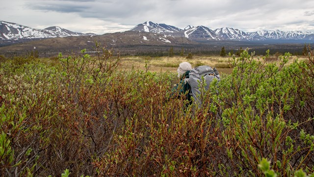
Backpacking in Alaska
Get acquainted with what makes backpacking in Alaska unique and familiarize yourself with these backcountry tips before you plan your trip. 
Telaquana Route Photos
Images taken along the Telaquana Route. |
Last updated: October 12, 2021