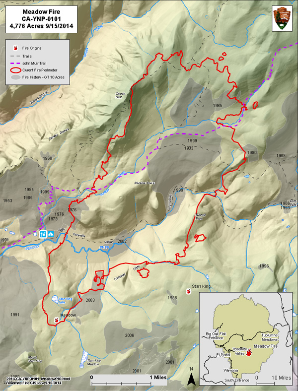
Meadow Fire
Meadow Fire (37 42.738 x 119 30.541 –Mariposa Co., 7,870', August 16): The fire is at 4,772 acres and 85% containment. On September 16 at 0600 the South Central Sierra Interagency Incident Management Team turned this fire back to the park. It is now being managed by a Type 3 organization with a smaller over-head and two wildland fire modules team. The strategy is to continue to confine and contain the fire perimeter, monitor the fire and utilize Minimum Impact Suppression Tactics (MIST) tactics and natural barriers as needed.
Open trails:
- Little Yosemite Valley Campground (LYV)
- The Mist, Panorama and Half Dome Trails and all climbing routes on Half Dome.
- Vogelsang Backpackers' Camp.
- The Tenaya Lake Trail
Closed Trails:
- Echo Creek Drainage to LYV
- Sunrise Creek Drainage to LYV (John Muir Trail)
- Merced River Corridor to Merced Lake Ranger Station
- Nevada falls east through LYV along the Merced River corridor
- Sunrise trail to Clouds Rest from Tenaya Lake
For wilderness access and trail closures, questions please call (209) 372-0826.
Air Quality
Visitors, campers, employees are likely to have air quality smoke impacts overnight and early morning hours in Yosemite Valley. Although air quality has improved, smoke may continue to be visible through the coming days. At the higher elevations smoke from the Lembert and Cathedral fires was also visible due to windy conditions at ridge tops. The entire region is experiencing smoke and hazy conditions from numerous fires statewide, including the El Dorado National Forest, King Fire, near Pollack Pines, and other state wide wild fires.
Other Yosemite Fires managed for multiple objectives
Cathedral (37 51.843 x 119 23.720 –Tuolumne Co., 9,140', July 16) This fire is now at 15 acres and continues to be active. It is northeast of Cathedral Peak. Smoke is visible from many Tuolumne Meadows locations.
Lembert (37 53.159 x 119 19.059 –Tuolumne Co., 9,250', July 16) This fire is at 1 acre and continues to smolder and creep through surface fuels in a lodgepole pine forest. It is east of Lembert Dome. Smoke is periodically visible from locations in Tuolumne Meadows.
Mount Starr King (37 43.21 x 119 28.108 –Mariposa Co., 8,730', July 16) This fire has been suppressed.
As with any fire incident in Yosemite National Park, firefighter and public safety is our number one priority. We appreciate everyone's assistance with this priority.
For More Information
Fire information: e-mail us, 209/372-0480.
For Yosemite air quality data and webcams: www.nps.gov/yose/naturescience/aqmonitoring.htm
For smoke updates: www.californiasmokeinfo.blogspot.com

