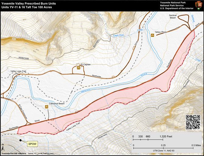
The Taft Toe prescribed fire project is projected to begin on Thursday morning, October 15. A test burn will commence near the Four Mile Trail and will proceed to the west. It is projected to take one and half days to complete ignitions of the burn and then approximately three to four days to burn down.
The Taft Toe prescribed fire project includes two units within Yosemite Valley. The 111-acre project is a narrow forested area. The proposed project is approximately three miles in length along Southside Drive of the Valley, and just east of Bridalveil Straightaway and Sentinel Beach picnic area. Parts of the unit were burned in 1993, 1995, and 1997; some segments have no recorded fire history. The project will be mopped up, patrolled and monitored after the fire.
A common objective for all the prescribed burns conducted in Yosemite Valley since the practice was introduced in the 1970s, is to use fire as an ecosystem restoration and management tool. In the absence of fire, the density of shade-tolerant species such as white fir and incense-cedar, along with forest litter and duff accumulations are now at unnatural and unacceptable levels. The purposes of the treatments called for in this burn plan are to reduce the density of small diameter (less than six-inch) mixed conifer species and accumulations of dead and down woody debris, and to restore and maintain the open forests and meadows. The restoration and maintenance of the Valley’s plant communities will be accomplished primarily through the application of fire and selective mechanical thinning. Moderate over-story mortality is acceptable. This properly timed and scheduled treatment will create more open forest stands, halt or mitigate the encroachment of trees into the meadows, and over time, open past vistas lost due to overstocked forested areas and shrinking meadows.
Smoke will be visible during the prescribed fire. Fire managers have worked with the Mariposa County Air Pollution District (MCAPCD) to time the project to coincide with favorable weather that will facilitate good air quality and disperse smoke into the atmosphere. A burn permit has been issued to the park by MCAPCD. Smoke monitoring equipment will be deployed and installed in nearby smoke-sensitive communities. Air quality information will be available through notifications and interactions with park employees, visitors, and adjacent communities.
The project is identified in the Yosemite Fire Management and Programmatic Environmental Impact Statement Plan of March 2004.

