Start date: 8/13/17 2:30 p.m.
Size: 7,531 acres
Containment: 47%
Incident Personnel: 50
Cause: Unknown
Helicopters: 1
Fuels: Mixed conifer and red fir
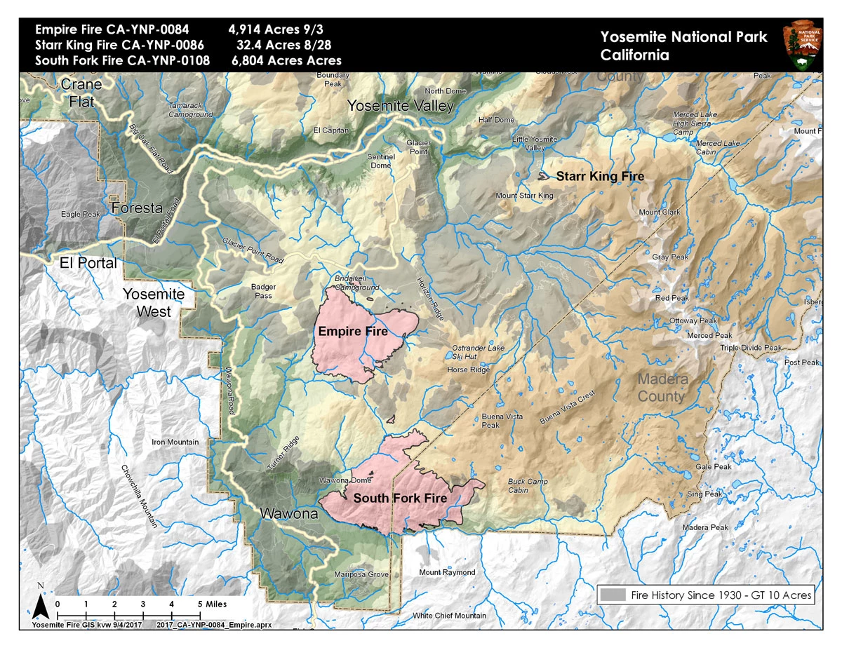
Fire remains quiet near the community of Wawona. The most activity yesterday was on the east flank burning into the wilderness through scattered pockets of dense fuel and the south flank backing into the South Fork of the Merced. There was an increase in acreage due to more accurate mapping. Thunderstorms are predicted this afternoon with slightly cooler temperatures and higher relative humidities, producing gusty and erratic winds.
The northern spot fire remains south of handline at Turner meadow, crews brought fire down to Chilnualna Creek to the secure the spot fire with the main fire. Patrols continue along portions of the fire closest to Wawona. There may be some burning well interior and visible smoke with increased winds due to the storms. Bucket work may be continued on the southern boundary of the fire. Both spot fires south of the South Fork of the Merced drainage were contained and secured with hose lays and handlines. Sections of the north flank and the entire east flank are continuing to burn in the wilderness, and will be monitored by aircraft due to steep and rugged terrain. As fire burns into the high country wilderness it will burn actively through pockets of dense vegetation but will then slow down as it progresses into sparse vegetation and natural granite barriers limiting smoke production. This high country wilderness area has minimal values at risk.
The following trail and area closures are in place until further notice:
- The Swinging Bridge Trail on both the north and south sides of the South Fork of the Merced River.
- The Chilnualna Falls Trail from Wawona Trailhead to the top of Chilnualna Falls.
- The two mile connecting trail heading north from the top of Chilnualna Falls to the intersection of the Buena Vista Trail.
- The Chilnualna Creek Trail from the top of Chilnualna Falls east to the intersection of the Buena Vista and Buck Camp trails (Just east of Johnson Lake).
- Turner Meadow Trail
- Turner Meadow intersection east to Buena Vista trail
- Off-trail areas in the vicinity of the South Fork Fire Area, including the swimming holes north of Chilnualna Creek.
- All climbing routes on and around Wawona Dome are closed.
For additional Information:
- Fire Information: Yose_Fire_Info@nps.gov, (209) 379-1493
- Yosemite National Park Fire Information website: http://www.nps.gov/yose/blogs/fireinfo.htm
- Facebook: Search-- Yosemite Fire and Aviation: @YosemiteFire
- Twitter: Search @YosemiteFire https://twitter.com/YosemiteFire
- Air Quality and webcams: https://www.nps.gov/yose/learn/nature/aqmonitoring.htm
- Daily Air Quality Forecast:https://www.wildlandfiresmoke.net/outlooks/2017/CentralSierraFires#Area2
- Inciweb: https://inciweb.nwcg.gov/incident/5502/

