Directions

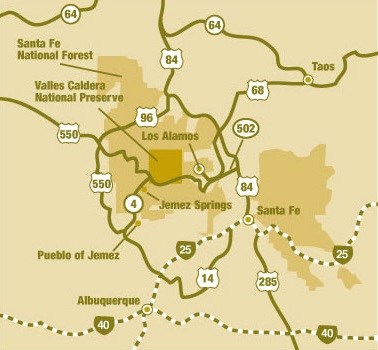
Simple map of Valles Caldera National Preserve, surrounding area, and nearby roads
Map of Valles Caldera National Preserve and surrounding cities, highways, and interstates.

Valles Caldera National Preserve covers nearly 89,000 acres nestled inside a volcanic caldera in north central New Mexico. The main park entrance is located on NM-4, approximately halfway between the towns of Jemez Springs to the west and Los Alamos to the east.

Commercial airlines serve the following airports near Valles Caldera National Preserve all year: Albuquerque Sunport and Santa Fe Municipal Airport.

Getting Here by Bus
Bus service is not available to Valles Caldera National Preserve. The nearest bus station is in Albuquerque. Contact Greyhound for specific schedules.

Getting Here by Train
Train service is not available to Valles Caldera National Preserve. The nearest train depots are in Albuquerque and Santa Fe. Contact Amtrak for specific schedules.

Getting Here by Car

From Albuquerque:
  • Take I-25 North and exit onto Highway 550 (Farmington Highway - old Hwy 44).
  • In San Ysidro, take NM-4 toward Jemez Pueblo and Jemez Springs.
  • Follow NM-4 at fork at La Cueva (stay right).
  • Valles Caldera National Preserve is about 22 miles up NM-4 from Jemez Springs. Look for the Main Gate at Mile Marker 39.2. Driving time from the intersection of I-25 and I-40 is approximately 2 hours.
From Santa Fe:
  • Head north on Highway 84-285 past the Santa Fe Opera.
  • In Pojoaque, follow signs to Los Alamos and Hwy 502.
  • You can take the "truck route" to NM-4 below Los Alamos or drive through Los Alamos and follow signs to "Jemez Mtns." (NM-4)
  • If you pass through Los Alamos proper, be prepared to pass through a security checkpoint for the Los Alamos National Laboratory (LANL). Take Trinity Drive to Diamond. Take a left on Diamond, then a right on Jemez Road to the intersection with NM-4. Take a right (away from Bandelier National Monument), following the highway up and into the Jemez Mountains.
  • Valles Caldera National Preserve is 18 miles up NM-4 from Los Alamos. Driving time from Santa Fe is approximately 1.5 hours.
There are several things that can affect your driving experience to the park -- road accessibility, road construction, and fast-changing weather. We recommend that visitors check the following resources before traveling:
  • National Weather Service forecast for New Mexico
  • New Mexico Roads
  • Road conditions are also available by calling 511, the Nation Traveler Information System. If your phone does not support 511, call 1-800-432-4269. Both numbers are toll-free.
Warning about GPS Systems! Vehicle Navigation Systems and GPS units may provide inaccurate information—sending drivers the wrong way on one-way roads, leading them to dead ends in remote areas, or sending them on roads which are closed at certain times of year. Make sure to use Valles Caldera National Preserve road maps available at entrance stations.

Alternative Fuel Vehicles

Do you plan to travel to the park in an alternative fuel vehicle? If so, good for you! Your actions help us reduce greenhouse gas emissions and reduce petroleum use. Plan your trip with the Alternative Fueling Station Locator from the Department of Energy (search on zip code 87025).

Last updated: February 21, 2023

Park footer

Contact Info

Mailing Address:

090 Villa Louis Martin Dr.
Jemez Springs, NM 87025

Phone:

505-670-1612
Ranger Station (for general park information)

Contact Us

Tools