|
"The Bad Lands grade all the way from those that are almost rolling in character to those that are so fantastically broken in form and so bizarre in color as to seem hardly properly to belong to this earth." Theodore Roosevelt 
NPS Photo Geologic Formation The story of the badlands begins over 65 million years ago during the Paleocene Epoch. The dinosaurs had just become extinct at the end of the Cretaceous Period. The western half of North America was buckling and folding to create the Rocky Mountains. Large amounts of sediments were forming as water, wind, and freezing worked to break down the mountains. These sediments, mostly sand, silt, and mud, were carried off the eastern slopes by ancient rivers and deposited here in layers. Volcanoes in South Dakota, Montana, Idaho, and across the west were also erupting during this time, spitting out huge amounts of ash. Some of this volcanic ash was blown or carried by rivers into North Dakota and accumulated in standing water. Over time, the sediments turned into the sandstone, siltstone, and mudstone layers now exposed in the park, while the ash layers became bentonite clay. During the epochs that followed, the land continued to change. Deposition from the mountains in the west continued throughout much of the Eocene, Oligocene, and Miocene epochs. Then as the Pliocene Epoch began, erosion dominated and the layers began to be stripped away. Rivers meandered through broad, shallow valleys across the western Dakotas and eastern Montana plains. Although the rivers changed their courses many times, when the Pliocene Epoch came to a close about two million years ago, one of these rivers existed in almost the same position as the modern Little Missouri River. This river flowed northward to merge first with the ancestral Yellowstone River near Williston, North Dakota, and then merged with the Missouri River, continuing northeastward through Saskatchewan and Manitoba to Hudson Bay. 
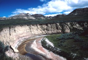
NPS Photo In the Pleistocene Epoch, the time period of numerous Ice Ages, which began about two million years ago, great continental ice sheets advanced southward from present-day Canada and reached as far as the upper North Unit boundary in the park. The ice blocked the flow of the north-flowing rivers, forcing them to create new courses eastward and southward, causing them to empty into the Mississippi River instead of Hudson Bay. By the time the ice retreated, the northern portions of both the Little Missouri and Missouri rivers were entrenched in their new channels. The Little Missouri’s new course to the north followed a steeper course, causing the whole river to flow faster and begin cutting deeply into the land. Slicing easily through the soft sedimentary rocks, the river and its tributaries carved the fantastically broken topography that is today’s badlands. The Fossil Record Leaves and branches would fall into the still waters of the swamps and build up until they formed a dense layer of vegetation called peat. Over time, pressure from overlying sediments compacted the peat and caused chemical changes to transform it into a soft, woody-textured coal called lignite (from the Latin ligneous, meaning wood). When Theodore Roosevelt lived in the badlands in the 1880s, he and his ranch hands shoveled lignite coal from the hillsides to use in their stove. 
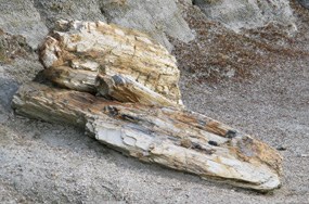
NPS Photo Some forests were buried by flood deposits or volcanic ash falls. When a plant or animal is buried quickly, it is protected from decaying and has a better chance of becoming a fossil. Groundwater moving through the silica-rich volcanic ash and other sediments can dissolve the silica, or quartz. When this silica-rich water soaked into the trees, organic compounds in the wood were dissolved and replaced by very small crystals of quartz. In some cases, the quartz crystals are so small that much of the internal structure of the trees is preserved, including the growth rings. This process of quartz replacing wood is called petrifaction. Click on Fossils for more information. 
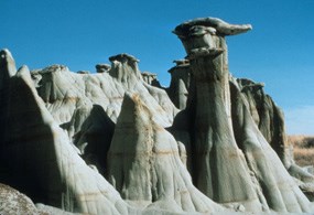
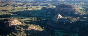
NPS Photo The Present Landscape Lightning strikes and prairie fires can ignite coal beds, which then may burn for many years. When a coal bed burns, it bakes the overlying sediments into a hard, natural brick that geologists call clinker, but is locally called "scoria." The red color of the rock comes from the oxidation of iron released from the coal as it burns. The burning lends both color to the badlands and helps to shape them. These hardened rocks are more resistant to erosion than the unbaked rocks nearby. Over time, erosion has worn down the less resistant rocks, leaving behind a jumble of knobs, ridges, and buttes topped with durable red scoria caps. Theodore Roosevelt National Park preserves a wealth of geologic information that can be enjoyed by visitors and studied by scientists. Much of that information tells us about events that occurred long ago, while some small-scale processes can be seen occurring over days, weeks, months, or even years. Just a short visit here can give visitors insight into the past, instill wonder, and inspire questions and a desire to learn more. You are welcome to explore Theodore Roosevelt National Park and make your own discoveries about the rocks and fossils found here. Please remember, however, that each rock and fossil may be a clue to the geologic history of the park, and must be left where they are found for other visitors to view and for scientists to study. Collecting of any park resource is not allowed. Learn more about Theodore Roosevelt National Park's Natural Features & Ecosystems. |
Last updated: April 10, 2015
